Transdisciplinary research+data center of @columbiaclimate studying human-environment interactions. Free data, map svcs+tools. Our main program is NASA SEDAC.
Palisades NY-Lamont Campus
Joined November 2008
- Tweets2.9K
- Following166
- Followers1.7K
- Likes1.6K
Replying to @columbiaclimate
@columbiaclimate @ciesin’s Juan Martinez presents newest approaches to multidimensional poverty measures, @ at Human Planet Forum 2023 July 11-12. Agenda and zoom link for day 2: bit.ly/3NERcNW bit.ly/3NMojQ2
How will decisions like State Farms’ to stop insuring in CA influence climate adaptation and/or managed retreat?@Alex_deS+others from @columbiaclimate comment: news.climate.columbia.edu/20… Explore related topics @ the Managed Retreat conference June 20-23 adaptation.ei.columbia.edu/m…
The implications of climate-change-induced migration are the subject of an @LSEnews podcast, featuring @ciesin @columbiaclimate research scientist Susana Adamo: blogs.lse.ac.uk/usappblog/20…
@ciesin’s #NASAsedac Hazards Mapper displays near-real-time data on fires, earthquakes, air quality+for the U.S., flood+tornado warnings. It can also estimate population in proximity to a hazardous event and identify nearby facilities at risk. sedac.ciesin.columbia.edu/da…
This Post is from an account that no longer exists. Learn more
177
New! Easy-to-use flood planning tool contains digitized data for all NY (except NYC). Developed by @columbiaclimate @ciesin's #NASAsedac. Blog: news.climate.columbia.edu/20… Mapping tool: bit.ly/42NiRTi
Job Opportunity: @ciesin is looking for a new associate director for our Science Applications Division, one of 4 divs. —w/Geospatial Applications, Data Ctr Svcs+IT—w/in this center of the new @columbiaclimate school. Go here for a description+to apply: academic.careers.columbia.ed…
New! Detailed air quality estimates for public health research developed by Harvard researchers+released by #NASAsedac; for urban+non-urban areas of the US 2000‒2019. sedac.ciesin.columbia.edu/da… @columbiaclimate
US climate risks projected @ county level for 2040‒2049 now available from #NASAsedac. Projections take into account multiple hazards+ evolving exposure+vulnerability. Maps display vulnerability, exposure, hazard+a composite index.
sedac.ciesin.columbia.edu/da… @columbiaclimate
This major upgrade to the tool displays hazards data of 14 types, in the US+PR (as available) @ census tract level. @ciesin helped w/the GIS analysis.
Today, AllianceBernstein & the @columbia_ncdp at the @ColumbiaClimate announced the launch of version 2.0 of the Natural Hazards Index map application, a public tool examining weather & climate vulnerabilities across the U.S. Read more on this development: allncbrnstn.co/3UIFhSr
174
We're hiring! New Associate Director for our Science Applications Division @ciesin, come join a great team!
academic.careers.columbia.ed…
1
83
Our #NASASedac data set gives a preliminary assessment of coastal Ramsar Sites at risk to inundation from sea level rise bit.ly/3KZHzZX
China 🇨🇳 has added 1⃣8⃣ new #Wetlands of International Importance!
The country has now designated 8⃣2⃣ such “Ramsar Sites” in total. The new sites extend over more than 320,000 hectares, across the country.
Read more: bit.ly/3KuS8D3
A 2-year, 1/2-million dollar award from @NASA to @columbiaclimate's @ciesin will fund development of an innovative virtual classroom for researchers at varied career levels+bkgs to learn how open science can support scientific discoveries. news.climate.columbia.edu/20…
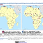
Internal migration from the slow-onset impacts of climate change—what does the future hold? This terrific article by @NASAEarthdata writer Joseph Smith describes the innovative climate migration modelling techniques of our #NASAsedac data set Groundswell go.nasa.gov/3Yyj5KR
Watch @columbiaclimate's @Alex_deS+ @radleyhorton,+@Princeton's @ClimateOpp et al in webinar launching week-long talks on habitability concept in pop-environment studies. youtu.be/2pgjND-jcF8 Organizers:@HABITABLE_H2020+Managed Retreat Conference adaptation.ei.columbia.edu/m…
Read this NASA article on the climate and migration modelling Groundswell data set developed by @ciesin's main program #NASAsedac, w/@WorldBank
How will the slow-onset impacts of #climate change affect migration within low- and middle-income countries around the globe? A new feature describing NASA SEDAC's Groundswell dataset offers insights. #NASAsedac Image: The World Bank
Learn more: go.nasa.gov/3Yyj5KR
In-person/online seminar Mar 29 @Columbia, 1-2 EDT highlights @UN efforts to maintain the environmental agenda during crisis. @LucileMaertens+@luisrivelez w/Daniel Naujoks @UNatColumbia+@columbiaclimate @ciesin post-doc Fabien Cottier. cglink.me/2e9/r1926036
Register Now: PERN Cyberseminar on Concept of Habitability in Pop-Environment Studies, March 13‒20. bit.ly/3J94xNB Among presenters are @columbiaclimate's @Alex_deS+@radleyhorton,+@Princeton's @ClimateOpp Organized w/@HABITABLE_H2020 and adaptation.ei.columbia.edu/m…
LIVE TOMORROW Thurs 9:30am EST: Join a quick Twitterspaces conversation w/@ciesin’s James Gibson+@sdgstoday, on 4 @Esri Story Maps+data sets estimating #SDGs indicator progress—access to electric/an all-season road/public transport/an urban public space. teapaw.org/i/spaces/1ynJOaWPBaWKR…
Applications open for an associate research scientist to support research projects at @columbiaclimate’s @ciesin+CCSR, on climate-related mobility+conflict, integrating knowledge of climate, environmental+socioeconomic systems. apply.interfolio.com/121034
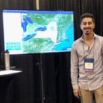
@ Coastal GeoTools 2023 Juan Martinez demos our soon-to-be released flood impact mapper to support sea level rise+flood planning for all NY (not NYC). Critical infrastructure, bldg footprints, flood scenarios+social vulnerability index. GIS know-how not required. Coming Soon!

ALT Juan Martinez stands to the right of the photo of a computer monitor displaying a Web page of our soon to be released New York Flood Impact Support System Application, a mapping tool which displays critical spatial and other infrastructure data for the entire state of New York, except New York City.