

Just having a fair dinkum go at life 🌴 🇦🇺 Doing lots of cool stuff at @soaratlas, Detail and Marlin (🦈)
San Francisco, CA
Joined July 2017
- Tweets4K
- Following1.1K
- Followers1.2K
- Likes3.9K




So apparently Iranian oil tankers are going to break the naval blockage by the US. Been looking at satellite imagery over Kharg Island for the last month and I cant see any ships loading crude? Maybe Im missing something? CC: @AnalyticaCamil1 @BabakTaghvaee1 @vcdgf555
Stunning imagery from Vantor showing the Kerch Bridge damage in Crimea. CC: @MAmir4564
soaratlas.com/maps/europe-uk…

Amir retweeted

From 2017 to 2026, Indonesia's Morowali Industrial Park has expanded at an extraordinary pace.
But the environmental cost is massive. Millions of tonnes of mining waste, water pollution, and damage to ecosystems have drawn scrutiny from researchers and Indonesian authorities.
Explore and Compare: tinyurl.com/2s46az3d
#Indonesia #Deforestation
Amir retweeted
We heard you can add up to 20 pictures on X now? Well, here's 20 maps from Soar Atlas added by our incredible community. 👀
Got maps of your own? Add them here, or explore our massive atlas and see what's happening around the world:👉 soaratlas.com


Amir retweeted
What does Luxembourg look like without its buildings and forests?
This high-res map shows the country's natural landscape using aerial laser scans (LiDAR) collected in 2024.
Explore:🗺 soaratlas.com/3D?mapId=14343…
The colours show how the land rises and falls, with red highlighting higher ground and darker colours showing lower areas.
#Luxembourg #Maps #LiDAR
El Nino-ing...

A desert so full of flowers it's visible from space? 🌸
Yes! Chile's Atacama Region, one of the driest places on Earth, occasionally turns into sea of wildflowers, known as the Desierto Florido.
Explore the map:🗺 tinyurl.com/354c7pcu
#chile #atacama #bloom #flower
5
158

Amir retweeted
High-res satellite imagery from Planet (via Radio Svoboda) shows fuel tanks at the Samara LPDS facility in Russia destroyed in greater detail, following reported Ukrainian drone attack. 🔥🔥
Explore the map here:🗺 tinyurl.com/ysv3srf3
#Russia #Ukraine #OSINT
Amir retweeted
💥Satellite imagery from Nov 8 shows massive smoke coming from an oil tanker burning in the western Strait of Hormuz, near Khasab, Oman.
The cause of the fire remains under investigation.
Explore and Compare: tinyurl.com/yc2dy74r
#StraitOfHormuz #Oman #OSINT
Amir retweeted
🔥🔍Satellite imagery from Nov 7 shows burn marks around modular structures at a Saudi National Guard facility in Najran, following reported Houthi missile and drone strikes.
Explore and Compare: tinyurl.com/4t3py2mm
#SaudiArabia #houthi #middleeast
Amir retweeted
An important discussion about the role of satellite imagery in documenting what's happening! Thank you to France 24 for the coverage. 🙏

Trois spécialistes d'imagerie satellitaire, @BenDoBrown, @BenTzionMacales et Michael Pearce de @SoarAtlas ont tous indiqué à la rédaction des @Observateurs n'avoir jamais vu d'images récentes de Gaza détruite sur Apple Maps. A lire sur le site de @France24_fr
Amir retweeted
🔍Mumbai, India, has transformed dramatically since this 1983 map. Decades of urban development have totally reshaped one of the world's most densely populated cities.
Explore and Compare: tinyurl.com/45npb44c
#India #mumbai
Amir retweeted
Election maps explore each country's political history. We have a bunch of them for you to look back through.
No matter the result tonight, it will be mapped out and part of history just like these.
🗺soaratlas.com/?q=Election
#USElections #ElectionMaps #USPolitics #Midterms2026
Absolutely horrific 🥺 RiP to all on board the plane soaratlas.com/maps/america-u…

1
3
456
Amir retweeted
🚨U.S. forces have struck Iran’s Qeshm Island on November 2nd, according to U.S. officials via WSJ.
The island sits at the Strait of Hormuz, a critical area for global oil supplies. These strikes come right as the U.S. midterm elections kick off, with reports of a possible post-election war escalation.
We will have to wait and see what satellite imagery can tell us about this event when it's made available.
#IranWar #MiddleEast #USA #qeshmisland

Amir retweeted
🚨As tensions rise in Iran, you can go back to our Iran Conflict bundle to see the bigger picture of this war.
250+ community maps documenting attacks, key findings and before-and-after imagery.
Iran Conflict Collection 🔍: tinyurl.com/bddeds23
#IranWar #MiddleEast #OSINT
Amir retweeted
Step back into the Cold War and explore a collection of vintage spy satellite images. Compare the world in the 1960s with today and see what's changed. View a detailed handmade 3D replica of the satellite.
Out Now:🚀👉 soaratlas.com/kh-7gambit
#ColdWar #History #Space
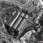
Meet San Francisco's famous Sutro Baths 🛁📸via aerial imagery from @sfgov on @SoarAtlas direct link to map in 1948 - tinyurl.com/2kzjkx67 Been going to Lands End for years. Never knew it looked like this before it burnt down in 1966. All that remains is basically a lake 😥


Amir retweeted
It's finally here!🎉👉: soaratlas.com/kh-7gambit
Step back into the Cold War and explore a handpicked collection of vintage spy satellite images with this stunning interactive experience. Compare the world in the 1960s with today and see just how much has changed.
Then take a closer look at the KH-7 Gambit 1 itself, with a detailed handmade 3D replica you can pan around.
All you have to do is pick a photo, explore, and use the slider to shift between past and present.
We put a lot of love and work into this so please let us know what you think.
#ColdWar #SatelliteImagery #History #Space
Amir retweeted
🚨Southeast Asia is facing another haze crisis.
NASA's fire map shows large hotspots across Indonesia. Satellite imagery shows smoke and active fires.
Hotspot Map 🔥: tinyurl.com/mpnpjdsj
Satellite 🛰: tinyurl.com/bdh6dc7m
#Indonesia #Singapore #Kalimantan