

The MapScaping Podcast is a #podcast for the #geospatial community. Just search for "MapScaping" Wherever you get your podcasts!
the internet
Joined September 2017
- Tweets7.7K
- Following116
- Followers36.3K
- Likes6.3K




Pinned Tweet
GeoHound Chrome extension automatically detects and saves GIS services (WMS, WMTS, ESRI) as you browse, eliminating manual copying and network request searches.
Just released GeoHound 2.0 !
MapScaping retweeted

Did you know that tomorrow (Nov 5, 11am eastern 8am pacific) I have a free webinar about tons of map hacks for making your Area of Interest pop? sign up here: esri.com/en-us/webinars/prod…
It's recorded and registrants get an email linking to the recording next week.

MapScaping retweeted

Last call! Agentic Coding for Geospatial starts Nov 16. In just 5 live sessions, you'll go from setting up your coding agent to building end-to-end GeoAI pipelines - getting work done faster while keeping the results grounded in sound science. Register at spatialthoughts.com/events/a…
MapScaping retweeted

Sovereign broadband satcom: you own it, you operate it, you decide who has access. Three operating models, one principle: national control stays intact, whether national, allied coalition, or hosted sovereign service.
Explore → hubs.li/Q04CgbnX0

It's a pretty manual process at the moment but I am working with a manufacturer to scale this .... because we've got our first order!
MapScaping retweeted

This MapScaping podcast episode features @utahgeological team. They share how they moved from a traditional ArcGIS Server setup toward a cloud-native approach leading to them turning off two servers & saving around $25K/yr
mapscaping.com/podcast/cloud…
These are my new "business cards" that I will be testing out at @cloudnativegeo in Snowbird.

This is a prototype for foldingglobes.com
Turns out the choice of paper is critical!

One of my consultant clients wanted to know more about the A5 grid system, so I had to re-listen to my own podcast episode with Felix Palmer yesterday to refresh my memory.


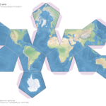
While I was at it, I used my latest project, foldingglobes.com, to generate a set of paper globes showing how A5 actually works: pentagons at the top level, breaking down into triangles, then pentagons again as the resolution gets finer.
MapScaping retweeted

Update „Geo Hound“: 2.0 geoobserver.de/2026/07/30/up… via @MapScaping #gistribe #gischat #fossgis #foss4g #OSGeo #spatial #geospatial #mapping #qgis #switch2qgis #gis #geo #geoObserver pls RT

Map Grid Generator
Generate hex, square, or triangle grids over any bounding box and download in your preferred vector format.
How do you make a GPS signal 100x stronger? Two things: move 20x closer to Earth, then just turn up the power. I talked to Tyler Reid, co-founder of Xona, about why that means building a 3kW satellite.
And it buys a position fix from a single satellite pass. Reading the Doppler shift off one fast moving LEO satellite gets you a position in tens of seconds. Normal GPS needs 4+ satellites for that.
Obvious follow up: broadcasting that close to GPS frequencies, aren't you the jamming problem? Xona's answer starts with protecting the GPS spectrum first, not adding to it. Full conversation: mapscaping.com/podcast/gps-b…