

https://xitter.cf/t.co/HL1wFaI0tx
Joined February 2008
- Tweets256
- Following101
- Followers8.4K
- Likes122
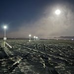




The Speed of the Earth returns to Burning Man 2026. Across a mile of open playa, bursts of light reveal something we can never feel: the Earth spinning beneath us at 1,156 feet per second.
Created by Kevin Kelly, David Rumsey, Dean Putney, Seth Roche, and Sonny Roche, this year’s installation lifts the lights 10 feet above the playa and adds glowing trails to each burst—transforming the invisible speed of our spinning planet into a streak of light racing across the desert.


David Rumsey retweeted

Come visit our Burning Man art piece that we installed today. It's a mile-long line of solar powered LED strobes that create a streak of light moving at the speed of the Earth's rotation. You can feel your spin. At 11:00 and far fence.

A remarkable Soviet atlas of the 1930s turns statistics into bold visual storytelling—using pictograms, isotypes, repetition, scale, color, and photomontage to make industrial, agricultural, and military data instantly understandable. #DataVisualization #SovietDesign #Isotype davidrumsey.com/luna/servlet…


A milestone for davidrumsey.com: over 150,000 historical maps and related images are now freely available online. After 26 years, the site has welcomed 50+ million visitors, delivered 20+ million free downloads, and seen 250+ million map views. Thank you to everyone who has explored with us. Next stop: 200,000 maps online by 2031. #Maps #History #Cartography #OpenAccess


Imagine Wikipedia—without the internet. The Bouasse-Lebel Encyclopedia transformed the knowledge of the late 19th century into hundreds of beautifully illustrated educational wall charts covering anatomy, astronomy, engineering, agriculture, natural history, geometry, and more. Explore this remarkable visual encyclopedia and discover the world as Victorians learned it. #History #Maps #Science #Art #Education All 180 charts hi res davidrumsey.com/luna/servlet…
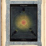
The title page and complete hand-colored plates from The Heavens Illustrated (London, 1844), a beautifully produced Victorian introduction to astronomy. Featuring 17 hand-colored illustrations of eclipses, the zodiac, planets, the Sun and Moon, and astronomical instruments, the work combined scientific education with striking visual design. Published at the dawn of Britain’s color-printing revolution, it reflects the era’s growing ambition to make knowledge both accessible and beautiful. davidrumsey.com/luna/servlet…


The 44-sheet Lunar Astronautical Charts (1967) were created in preparation for the Apollo 11 landing in 1969—the last hand-drawn maps of the Moon, and among the most beautiful. Here, a close-up of the Apollo 11 landing site in the Sea of Tranquility, between the Sabine C and Moltke craters. At the time, the far side remained unmapped and unseen. We’ve digitally joined all 44 sheets in GIS to form a complete globe. davidrumsey.com/luna/servlet…
A masterpiece of precision and artistry: Guillaume Henri Dufour’s Topographische Karte der Schweiz (1833–1863). Created at an impressive 1:100,000 scale, this 25-sheet national map set a new standard for scientific cartography in the 19th century. Steel-engraved with extraordinary detail, it uses delicate hachures to sculpt the Alps in three dimensions—capturing Switzerland’s dramatic terrain with remarkable clarity. Centered on the Bern Observatory and produced during a period of rapid technological progress, the map supported military planning, infrastructure, and national unity.
See all sheets: davidrumsey.com/luna/servlet…
600 Swiss topographic maps from 1870 are often considered the finest ever produced, blending remarkable precision with exceptional artistry. They are known as the Siegfried Survey. See all davidrumsey.com/luna/servlet…
A striking fusion of state propaganda and modernist design, Nippon (1937) is one of the most ambitious Japanese photobooks of the interwar era—and a high point of both modernist bookmaking and cultural messaging. Photos become maps! See the entire book davidrumsey.com/luna/servlet…
More than half of the glacial ice captured on this 1896 map of the Mont Blanc massif—straddling Switzerland, Italy, and France—has vanished, erased from the landscape within little more than a century. See full map: davidrumsey.com/luna/servlet…
The great glaciers of Tibetan Karakoram Mountains mapped in 1908 by H. Bystrom. These glaciers have not receded in the past 100 years. That is known as the "Karakoram Anomaly." Full map davidrumsey.com/luna/servlet…
Chronomapping Sunset Dunes in San Francisco by Ben Gitai. A living map that moves in time and space. davidrumsey.com/luna/servlet…
Qiu Zhijie’s all-seeing maps are transformative experiences that unsettle viewers’ sense of self and world. Unlike his earlier Mapping series, this group of 26 works integrates traditional Chinese brush-and-ink techniques, asking how calligraphy and painting can depict contemporary realities—dense cities, industrial zones, and shifting landscapes—while retaining their spontaneous vitality. Qiu seeks a form of “cartographic calligraphy” that blends realism with expressive freedom and reconciles the organic variability of nature with the geometric structures of modern life. Rooted in Chinese artistic tradition yet open to global diversity, his approach echoes Confucian ideas of relational harmony: through “family likenesses,” different cultures coexist without being flattened into a universal sameness. Qiu’s bird’s-eye views challenge Enlightenment cartography by redistributing knowledge and blurring boundaries between private and collective worlds. Acting as a mythmaker, he enlarges overlooked details into expansive narratives, transforming fragments of history into imaginative cosmologies. Drawing on the spirit of shan shui landscape painting—where cultural meaning outweighs strict topography—his maps question the neutrality of observation and recall the political dimensions of imperial mapping. Ultimately, Qiu’s cartography reimagines history, culture, and global relationships through poetic, critical vision. (Derived from "Viewed Through the Eye of A Bird: On Qiu Zhijie's Cartography" by Chang Tsong-Zung, translated by Don J. Cohn) davidrumsey.com/luna/servlet…


French astronomers Maurice Loewy & Pierre Puiseux took 6,000+ lunar photos over 500+ nights (1896–1910) They published the best 71 as an atlas that remained unsurpassed for 50+ years—hailed as “the ultimate achievement of nineteenth-century astronomical photography.” See all 71: davidrumsey.com/luna/servlet…
New York City Central Park and surrounds changes over time - 243 years in six maps: 1782, 1836, 1865, 1904, 1966, 2025. davidrumsey.com/luna/servlet…