

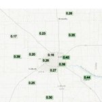






24-hour rainfall totals (inches) as of 12:30 Monday afternoon, courtesy of the TT Mesonet. List of measured totals on my "Steve Divine KCBD" Fb page.


Two more days of mild and warm weather, then cooling with rain likely. Details in the accompanying video.
Steve Divine retweeted

🌪️ ANOTHER tornado in New Mexico!
This landspout tornado was spotted south of Animas in the bootheel Tuesday afternoon.
If confirmed, this would be only the 3rd documented tornado in Hidalgo Co. since 1950 & the first ever recorded in Oct.
📹 Daniel Antonio
#NMwx @NWSElPaso
A pleasant stretch of October weather through Friday with temperatures gradually rising. Then turning cooler this weekend with a chance of rain.
The low temperature at the Lubbock airport this morning was 34°. Since there was not a freeze, our First Freeze contest continues.
Stop by the new Yates Flooring and Design store on Quaker to enter.
Reminder, you can only enter once.
#FirstFreeze
#KCBD
#YatesFlooring

Sun dogs! Also called, parhelia, mock suns, or false suns. They appear at the same elevation and to the right and/or left of the sun, about 22° away on either side. By the way, that’s about the…
Pictures by Steve and Maria Divine. 😊
#DivineTiming
#SunDog
#Parhelia
#Lubbock


Beautiful sunset Thursday, recorded from 5:30 to 8:30 PM (10/15). From our camera on our tower at 56th and Ave A, Lubbock.
In this video: When I expect the wind to ease, when and where freezing temperatures are likely and where they are possible, and a look at our weekend.
Areas highlighted under FLASH FLOOD WARNINGS through mid-evening (Wed). Numerous flooded roads in those areas (including a majority of roads in Cottle County). Avoid driving into water of an unknown depth. Many flood-related deaths occur when drivers ignore that advice..


Reminder, track storms w/ the Interactive Radar in the free KCBD Weather app. Radar echoes animate, lightning layer does not. Tap “Alerts” for current warnings/watches. Tap the Severe Thunderstorm Watch for additional info. Do the same with the warnings (yellow polygons).
The main severe threat across most of the area is strong wind gusts. For eastern areas, especially off the Caprock, large hail is also a concern. Locally heavy rainfall may result in flooding of low areas, streets, and other areas where rainwater typically collects.
The SEVERE THUNDERSTORM WATCH highlighted in the video I just posted has been cancelled. HOWEVER, a new SEVERE THUNDERSTORM WATCH has just been issued for the southern KCBD/FOX34 viewing area (until 2 AM CDT:

Another round of showers and a few embedded thunderstorms are expected tonight. Cooler and more stable conditions will keep the severe threat relatively low, though strong wind gusts and an instance or two of large hail is still possible, especially off the Caprock.
The usual way we post videos is, for a reason unknown to me, not working this evening. I've made several attempts with no success. I have, however, posted about the significant changes coming our way. You'll find it this evening - early Tuesday at kcbd.com/weather
