

Tracking Hurricanes, Typhoons, & Cyclones worldwide | Real-time updates | Stay safe & informed
Global Service
Joined July 2011
- Tweets35.7K
- Following1.1K
- Followers2.4K
- Likes41.5K






* A beautiful year is not about having everything but appreciating every blessing that comes your way. 🪔
Today, Tuesday, November 10, 2026, marks the celebration of the Gujarati New Year. One of the most cherished greetings exchanged is "Saal Mubarak," which means "Happy New Year!"
Although traditions may differ across cultures, the message is universal: appreciate the blessings we have, cherish the people in our lives, embrace new opportunities, and approach each new beginning with kindness and gratitude.
Thus, this celebration represents fresh beginnings, renewed hope, gratitude, and the opportunity to welcome the year ahead with optimism and faith.
#SaalMubarak to my family and friends! May the year ahead bring new hopes, new dreams, and beautiful beginnings to all! ❤️
Respectfully,
Roshin Rowjee


67


Congratulations, Governor #GinaHinojosa and Senator #JamesTalarico! May Texas shine brighter, and may our Lone Star State move forward with renewed hope, dignity, and promise.
Texas deserves and has voted for leadership that listens, inspires, and serves with purpose. May their victories mark the beginning of a new era in which every Texan has the opportunity to thrive, where fairness, equality, diversity, inclusion, and compassion guide our path forward, where every voice is valued, every child has the opportunity to succeed, and where the promise of a brighter tomorrow is shared by all, regardless of background or circumstance.
Everything is bigger in #Texas—including the hope for a better tomorrow! Praying for both of our new leaders, God's guidance & light.
Respectfully,
Roshin Rowjee
#NewChapterForTexas #HopeAndProgress


121
🌀 Cyclone Arnab / ARNAB UPDATE
— ANDHRA PRADESH, #INDIA 🇮🇳
⚠️ #ExtremelySEVERECyclonicStormArnab THREAT
📍 EXPECTED LANDFALL ZONE: Coastal #AndhraPradesh, potentially between Bapatla and Visakhapatnam, near the Kakinada and Godavari coastal region.
📅 EXPECTED DATE: Wednesday, October 28, 2026.
🕦 PROJECTED TIME: Around 11:30 a.m. Indian Standard Time (IST).
💨 PROJECTED WIND SPEEDS: Sustained winds of 185–210 km/h (115–130 mph), with powerful gusts reaching 230 km/h (143 mph).
🌧️ MAJOR THREATS
Extremely heavy rainfall and life-threatening flooding.
Destructive winds capable of damaging buildings, uprooting trees, and bringing down power lines.
Dangerous storm surge and coastal inundation in low-lying areas.
Hazardous seas along the Andhra Pradesh and southern Odisha coastlines.
🚨 SAFETY ALERT: Coastal residents should prepare for potentially destructive conditions, secure loose outdoor objects, stock essential supplies, and follow evacuation instructions from local authorities. Fishermen should stay out of the sea.
Stay alert. Prepare early. Protect lives.
Respectfully,
Roshin
Hurricane/Typhoon/Cyclone Updates & Information

🌀 #CycloneArnab / #ARNAB UPDATE
— ANDHRA PRADESH, INDIA 🇮🇳
⚠️ EXTREMELY SEVERE #CyclonicStormArnab THREAT
📍 EXPECTED LANDFALL ZONE: Coastal Andhra Pradesh, potentially between Bapatla and Visakhapatnam, near the Kakinada and Godavari coastal region.
📅 EXPECTED DATE: Wednesday, October 28, 2026.
🕦 PROJECTED TIME: Around 11:30 a.m. Indian Standard Time (IST).
💨 PROJECTED WIND SPEEDS: Sustained winds of 185–210 km/h (115–130 mph), with powerful gusts reaching 230 km/h (143 mph).
🌧️ MAJOR THREATS
Extremely heavy rainfall and life-threatening flooding.
Destructive winds capable of damaging buildings, uprooting trees, and bringing down power lines.
Dangerous storm surge and coastal inundation in low-lying areas.
Hazardous seas along the Andhra Pradesh and southern Odisha coastlines.
🚨 SAFETY ALERT: Coastal residents should prepare for potentially destructive conditions, secure loose outdoor objects, stock essential supplies, and follow evacuation instructions from local authorities. Fishermen should stay out of the sea.
Stay alert. Prepare early. Protect lives.
Respectfully,
Roshin
Hurricane/Typhoon/Cyclone Updates & Information

2
398
🌀 #CycloneArnab / #ARNAB UPDATE
— ANDHRA PRADESH, INDIA 🇮🇳
⚠️ EXTREMELY SEVERE #CyclonicStormArnab THREAT
📍 EXPECTED LANDFALL ZONE: Coastal Andhra Pradesh, potentially between Bapatla and Visakhapatnam, near the Kakinada and Godavari coastal region.
📅 EXPECTED DATE: Wednesday, October 28, 2026.
🕦 PROJECTED TIME: Around 11:30 a.m. Indian Standard Time (IST).
💨 PROJECTED WIND SPEEDS: Sustained winds of 185–210 km/h (115–130 mph), with powerful gusts reaching 230 km/h (143 mph).
🌧️ MAJOR THREATS
Extremely heavy rainfall and life-threatening flooding.
Destructive winds capable of damaging buildings, uprooting trees, and bringing down power lines.
Dangerous storm surge and coastal inundation in low-lying areas.
Hazardous seas along the Andhra Pradesh and southern Odisha coastlines.
🚨 SAFETY ALERT: Coastal residents should prepare for potentially destructive conditions, secure loose outdoor objects, stock essential supplies, and follow evacuation instructions from local authorities. Fishermen should stay out of the sea.
Stay alert. Prepare early. Protect lives.
Respectfully,
Roshin
Hurricane/Typhoon/Cyclone Updates & Information

3
518
* Very Severe #CyclonicStormArnab / #Arnab over Westcentral
Bay of Bengal [Cyclone Warning for Andhra Pradesh and adjoining South Odisha coasts
The very severe #CycloneArnab over Westcentral Bay of Bengal moved
west-northwestwards with a speed of 25 kmph during past 6 hours, and lay centered at 0230 hrs IST of today, the 27th October, 2026 over the same region near latitude 15.9°N and longitude 85.4°E, 300 km southeast of Vishakhapatnam (Andhra Pradesh), 360 km east-southeast of Kakinada (Andhra Pradesh), 380 km south of Gopalpur (Odisha), 460 km east of Machilipatnam (Andhra Pradesh), 530 km east of
Bapatla (Andhra Pradesh) and 920 km west-northwest of Sri Vijaya Puram (Andaman Islands).
Arnab is very likely to continue to move west-northwestwards till evening of 27th October and thereafter, it is very likely to move northwestwards and cross Andhra Pradesh & Yanam coasts between Bapatla and
Visakhapatnam, close to Yanam as a very severe cyclonic storm with the maximum sustained wind speed of 115-125 kmph gusting to 140 kmph by forenoon of 28th October, 2026. The system is under continuous surveillance of the Doppler Weather Radar at Vishakhapatnam.
*** STORM SURHE WARNING ***
Storm surge of 1.0 to 1.5 m height above astronomical tide is very likely to inundate low lying areas of Andhra Pradesh during the time of landfall. The maximum peak surge is expected over near Kakinada and Yanam (Puducherry UT).
Respectfully,
Roshin
Hurricane/Typhoon/Cyclone Updates & Information

* Very Severe #CyclonicStormArnab / #Arnab over Westcentral
Bay of Bengal [Cyclone Warning for Andhra Pradesh and adjoining South Odisha coasts
The very severe #CycloneArnab over Westcentral Bay of Bengal moved
west-northwestwards with a speed of 25 kmph during past 6 hours, and lay centered at 0230 hrs IST of today, the 27th October, 2026 over the same region near latitude 15.9°N and longitude 85.4°E, 300 km southeast of Vishakhapatnam (Andhra Pradesh), 360 km east-southeast of Kakinada (Andhra Pradesh), 380 km south of Gopalpur (Odisha), 460 km east of Machilipatnam (Andhra Pradesh), 530 km east of
Bapatla (Andhra Pradesh) and 920 km west-northwest of Sri Vijaya Puram (Andaman Islands).
Arnab is very likely to continue to move west-northwestwards till evening of 27th October and thereafter, it is very likely to move northwestwards and cross Andhra Pradesh & Yanam coasts between Bapatla and
Visakhapatnam, close to Yanam as a very severe cyclonic storm with the maximum sustained wind speed of 115-125 kmph gusting to 140 kmph by forenoon of 28th October, 2026. The system is under continuous surveillance of the Doppler Weather Radar at Vishakhapatnam.
*** STORM SURHE WARNING ***
Storm surge of 1.0 to 1.5 m height above astronomical tide is very likely to inundate low lying areas of Andhra Pradesh during the time of landfall. The maximum peak surge is expected over near Kakinada and Yanam (Puducherry UT).
Respectfully,
Roshin
Hurricane/Typhoon/Cyclone Updates & Information

* Very Severe #CyclonicStormArnab / #Arnab over Westcentral
Bay of Bengal [Cyclone Warning for Andhra Pradesh and adjoining South Odisha coasts
The very severe #CycloneArnab over Westcentral Bay of Bengal moved
west-northwestwards with a speed of 25 kmph during past 6 hours, and lay centered at 0230 hrs IST of today, the 27th October, 2026 over the same region near latitude 15.9°N and longitude 85.4°E, 300 km southeast of Vishakhapatnam (Andhra Pradesh), 360 km east-southeast of Kakinada (Andhra Pradesh), 380 km south of Gopalpur (Odisha), 460 km east of Machilipatnam (Andhra Pradesh), 530 km east of
Bapatla (Andhra Pradesh) and 920 km west-northwest of Sri Vijaya Puram (Andaman Islands).
Arnab is very likely to continue to move west-northwestwards till evening of 27th October and thereafter, it is very likely to move northwestwards and cross Andhra Pradesh & Yanam coasts between Bapatla and
Visakhapatnam, close to Yanam as a very severe cyclonic storm with the maximum sustained wind speed of 115-125 kmph gusting to 140 kmph by forenoon of 28th October, 2026. The system is under continuous surveillance of the Doppler Weather Radar at Vishakhapatnam.
*** STORM SURHE WARNING ***
Storm surge of 1.0 to 1.5 m height above astronomical tide is very likely to inundate low lying areas of Andhra Pradesh during the time of landfall. The maximum peak surge is expected over near Kakinada and Yanam (Puducherry UT).
Respectfully,
Roshin
Hurricane/Typhoon/Cyclone Updates & Information

2
742
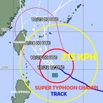
#Champi #SuperTyphoonChampi #Taiwan #TyphoonChampi
0600UTC 22 October 2026
Center Position 20.7N 125.4E
Vector to 6 HR Position
NW 13 km/h
Minimum Pressure 925 hPa
Maximum Wind Speed 51 m/s
Gust 63 m/s
Radius of over 15m/s winds 300km
Radius of over 25m/s winds 150km
Radius of 70% probability circle 30km

1
351
#Champi #SuperTyphoonChampi #Taiwan
0600UTC 22 October 2026
Center Position 20.7N 125.4E
Vector to 6 HR Position
NW 13 km/h
Minimum Pressure 925 hPa
Maximum Wind Speed 51 m/s
Gust 63 m/s
Radius of over 15m/s winds 300km
Radius of over 25m/s winds 150km
Radius of 70% probability circle 30km

302
#HurricaneSimon #Simon
NWS National Hurricane Center Miami FL
500 AM MST Mon Oct 12 2026
...SIMON CRAWLING NORTHWEST JUST OFFSHORE OF MEXICO...
...DANGEROUS WINDS AND FLOODING RAINS CONTINUE ALONG THE COAST...
SUMMARY OF 500 AM MST...1200 UTC...INFORMATION
----------------------------------------------
LOCATION...20.1N 106.4W
ABOUT 50 MI...80 KM WSW OF CABO CORRIENTES MEXICO
ABOUT 215 MI...345 KM S OF MAZATLAN MEXICO
MAXIMUM SUSTAINED WINDS...115 MPH...185 KM/H
PRESENT MOVEMENT...NW OR 315 DEGREES AT 2 MPH...4 KM/H
MINIMUM CENTRAL PRESSURE...958 MB...28.29 INCHES
WATCHES AND WARNINGS
--------------------
CHANGES WITH THIS ADVISORY:
None.
SUMMARY OF WATCHES AND WARNINGS IN EFFECT:
A Hurricane Warning is in effect for...
* Playa Perula to El Roblito
* Las Islas Marias
A Hurricane Watch is in effect for...
* North of El Roblito to Bahia Tempehuaya
A Hurricane Warning means that hurricane conditions are expected
somewhere within the warning area. Preparations to protect life
and property should be rushed to completion.
A Hurricane Watch means that hurricane conditions are possible
within the watch area within 48 hours.
Interests elsewhere in west-central Mexico should continue to
monitor as changes to watches and warnings are possible later today.
For storm information specific to your area, please monitor products
issued by your national meteorological service.
DISCUSSION AND OUTLOOK
----------------------
At 500 AM MST (1200 UTC), the center of Hurricane Simon was located
near latitude 20.1 North, longitude 106.4 West. Simon is moving
slowly toward the northwest near 2 mph (4 km/h) and this general
motion at a somewhat faster speed is expected to continue into early
Tuesday. A gradual turn toward the northeast is forecast thereafter,
and Simon is expected to move inland across west-central Mexico
around midweek.
Maximum sustained winds are near 115 mph (185 km/h) with higher
gusts. Simon is a category 3 hurricane on the Saffir-Simpson
Hurricane Wind Scale. Some additional weakening is forecast, however
Simon is expected to remain a hurricane through midweek. Rapid
weakening is likely after Simon moves inland.
Hurricane-force winds extend outward up to 15 miles (30 km) from
the center and tropical-storm-force winds extend outward up to 60
miles (95 km).
The estimated minimum central pressure is 958 mb (28.29 inches).
1
353
#HurricaneSimon #Simon
NWS National Hurricane Center Miami FL
500 AM MST Mon Oct 12 2026
...SIMON CRAWLING NORTHWEST JUST OFFSHORE OF MEXICO...
...DANGEROUS WINDS AND FLOODING RAINS CONTINUE ALONG THE COAST...
SUMMARY OF 500 AM MST...1200 UTC...INFORMATION
----------------------------------------------
LOCATION...20.1N 106.4W
ABOUT 50 MI...80 KM WSW OF CABO CORRIENTES MEXICO
ABOUT 215 MI...345 KM S OF MAZATLAN MEXICO
MAXIMUM SUSTAINED WINDS...115 MPH...185 KM/H
PRESENT MOVEMENT...NW OR 315 DEGREES AT 2 MPH...4 KM/H
MINIMUM CENTRAL PRESSURE...958 MB...28.29 INCHES
WATCHES AND WARNINGS
--------------------
CHANGES WITH THIS ADVISORY:
None.
SUMMARY OF WATCHES AND WARNINGS IN EFFECT:
A Hurricane Warning is in effect for...
* Playa Perula to El Roblito
* Las Islas Marias
A Hurricane Watch is in effect for...
* North of El Roblito to Bahia Tempehuaya
A Hurricane Warning means that hurricane conditions are expected
somewhere within the warning area. Preparations to protect life
and property should be rushed to completion.
A Hurricane Watch means that hurricane conditions are possible
within the watch area within 48 hours.
Interests elsewhere in west-central Mexico should continue to
monitor as changes to watches and warnings are possible later today.
For storm information specific to your area, please monitor products
issued by your national meteorological service.
DISCUSSION AND OUTLOOK
----------------------
At 500 AM MST (1200 UTC), the center of Hurricane Simon was located
near latitude 20.1 North, longitude 106.4 West. Simon is moving
slowly toward the northwest near 2 mph (4 km/h) and this general
motion at a somewhat faster speed is expected to continue into early
Tuesday. A gradual turn toward the northeast is forecast thereafter,
and Simon is expected to move inland across west-central Mexico
around midweek.
Maximum sustained winds are near 115 mph (185 km/h) with higher
gusts. Simon is a category 3 hurricane on the Saffir-Simpson
Hurricane Wind Scale. Some additional weakening is forecast, however
Simon is expected to remain a hurricane through midweek. Rapid
weakening is likely after Simon moves inland.
Hurricane-force winds extend outward up to 15 miles (30 km) from
the center and tropical-storm-force winds extend outward up to 60
miles (95 km).
The estimated minimum central pressure is 958 mb (28.29 inches).

217
#HurricaneSimon #Simon #Mexico
NWS National Hurricane Center Miami FL
300 PM CST Sun Oct 11 2026
...CORE OF HURRICANE SIMON CONTINUES TO SKIRT THE COAST OF
WEST-CENTRAL MEXICO WITH HURRICANE CONDITIONS LIKELY OCCURING...
...NEW HURRICANE WATCHES ISSUED FARTHER UP THE MEXICAN COAST...
SUMMARY OF 300 PM CST...2100 UTC...INFORMATION
----------------------------------------------
LOCATION...19.6N 105.8W
ABOUT 105 MI...170 KM WNW OF MANZANILLO MEXICO
ABOUT 55 MI...90 KM S OF CABO CORRIENTES MEXICO
MAXIMUM SUSTAINED WINDS...130 MPH...215 KM/H
PRESENT MOVEMENT...NNW OR 335 DEGREES AT 6 MPH...9 KM/H
MINIMUM CENTRAL PRESSURE...947 MB...27.97 INCHES
WATCHES AND WARNINGS
--------------------
CHANGES WITH THIS ADVISORY:
The government of Mexico has issued a Hurricane Watch for north of
El Roblito to Bahia Tempehuaya.
SUMMARY OF WATCHES AND WARNINGS IN EFFECT:
A Hurricane Warning is in effect for...
* Punta San Telmo to El Roblito
* Las Islas Marias
A Hurricane Watch is in effect for...
* North of El Roblito to Bahia Tempehuaya
DISCUSSION AND OUTLOOK
----------------------
At 300 PM CST (2100 UTC), the eye of Hurricane Simon was located
near latitude 19.6 North, longitude 105.8 West. Simon is moving
toward the north-northwest near 6 mph (9 km/h) and this general
motion is expected to continue over the next couple of days with a
gradual turn to the north and north-northeast on Tuesday into
Wednesday. On the forecast track, Simon is expected to pass near the
coast of west-central Mexico this afternoon and evening before
moving a little farther away on Monday. Simon is then forecast to
turn back towards the coast of Mexico on Wednesday.
Maximum sustained winds have decreased to near 130 mph (215 km/h)
with higher gusts. Simon is a category 4 hurricane on the
Saffir-Simpson Hurricane Wind Scale. Additional weakening is
forecast but Simon is still expected to be a strong hurricane as it
passes near the coast of west-central Mexico this afternoon and
evening. Simon is now expected to remain a hurricane when it moves
farther offshore again on Monday and Tuesday.
Hurricane-force winds extend outward up to 25 miles (35 km) from the
center and tropical-storm-force winds extend outward up to 60 miles
(95 km).
The estimated minimum central pressure is 947 mb (27.97 inches).
HAZARDS AFFECTING LAND
----------------------
WIND: Hurricane conditions are likely occuring in the Hurricane
Warning area, with hurricane conditions spreading northward later
this evening into Monday.
Hurricane conditions are possible within the watch area by
Wednesday, with tropical storm conditions possible by Tuesday night.
RAINFALL: Simon is expected to produce additional rainfall totals of
2 to 4 inches with isolated additional amounts of 8 inches over
portions of the states of Colima, Jalisco, Nayarit and Sinaloa
through early Thursday. Isolated maximum storm totals of 30 inches
are possible over portions of the states of Michoacan, Colima, and
Jalisco. This rainfall will produce life-threatening flooding and
mudslides or worsen any on-going flooding, especially in areas of
steep terrain.
STORM SURGE: A dangerous storm surge is expected along the immediate
coast near and to the east of where the center approaches land. Near
the coast, the surge will be accompanied by large and destructive
waves.
SURF: Swells generated by Simon will affect portions of the coast
of southwestern and west-central Mexico during the next few days.
These swells are likely to cause life-threatening surf and rip
current conditions. Please consult products from your local weather
office.
Forecaster Papin
=========
Respectfully,
Roshin
Hurricane/Typhoon/Cyclone Updates & Information

354
#HurricaneSimon #Simon #Mexico
NWS National Hurricane Center Miami FL
300 PM CST Sun Oct 11 2026
...CORE OF HURRICANE SIMON CONTINUES TO SKIRT THE COAST OF
WEST-CENTRAL MEXICO WITH HURRICANE CONDITIONS LIKELY OCCURING...
...NEW HURRICANE WATCHES ISSUED FARTHER UP THE MEXICAN COAST...
SUMMARY OF 300 PM CST...2100 UTC...INFORMATION
----------------------------------------------
LOCATION...19.6N 105.8W
ABOUT 105 MI...170 KM WNW OF MANZANILLO MEXICO
ABOUT 55 MI...90 KM S OF CABO CORRIENTES MEXICO
MAXIMUM SUSTAINED WINDS...130 MPH...215 KM/H
PRESENT MOVEMENT...NNW OR 335 DEGREES AT 6 MPH...9 KM/H
MINIMUM CENTRAL PRESSURE...947 MB...27.97 INCHES
WATCHES AND WARNINGS
--------------------
CHANGES WITH THIS ADVISORY:
The government of Mexico has issued a Hurricane Watch for north of
El Roblito to Bahia Tempehuaya.
SUMMARY OF WATCHES AND WARNINGS IN EFFECT:
A Hurricane Warning is in effect for...
* Punta San Telmo to El Roblito
* Las Islas Marias
A Hurricane Watch is in effect for...
* North of El Roblito to Bahia Tempehuaya
DISCUSSION AND OUTLOOK
----------------------
At 300 PM CST (2100 UTC), the eye of Hurricane Simon was located
near latitude 19.6 North, longitude 105.8 West. Simon is moving
toward the north-northwest near 6 mph (9 km/h) and this general
motion is expected to continue over the next couple of days with a
gradual turn to the north and north-northeast on Tuesday into
Wednesday. On the forecast track, Simon is expected to pass near the
coast of west-central Mexico this afternoon and evening before
moving a little farther away on Monday. Simon is then forecast to
turn back towards the coast of Mexico on Wednesday.
Maximum sustained winds have decreased to near 130 mph (215 km/h)
with higher gusts. Simon is a category 4 hurricane on the
Saffir-Simpson Hurricane Wind Scale. Additional weakening is
forecast but Simon is still expected to be a strong hurricane as it
passes near the coast of west-central Mexico this afternoon and
evening. Simon is now expected to remain a hurricane when it moves
farther offshore again on Monday and Tuesday.
Hurricane-force winds extend outward up to 25 miles (35 km) from the
center and tropical-storm-force winds extend outward up to 60 miles
(95 km).
The estimated minimum central pressure is 947 mb (27.97 inches).
HAZARDS AFFECTING LAND
----------------------
WIND: Hurricane conditions are likely occuring in the Hurricane
Warning area, with hurricane conditions spreading northward later
this evening into Monday.
Hurricane conditions are possible within the watch area by
Wednesday, with tropical storm conditions possible by Tuesday night.
RAINFALL: Simon is expected to produce additional rainfall totals of
2 to 4 inches with isolated additional amounts of 8 inches over
portions of the states of Colima, Jalisco, Nayarit and Sinaloa
through early Thursday. Isolated maximum storm totals of 30 inches
are possible over portions of the states of Michoacan, Colima, and
Jalisco. This rainfall will produce life-threatening flooding and
mudslides or worsen any on-going flooding, especially in areas of
steep terrain.
STORM SURGE: A dangerous storm surge is expected along the immediate
coast near and to the east of where the center approaches land. Near
the coast, the surge will be accompanied by large and destructive
waves.
SURF: Swells generated by Simon will affect portions of the coast
of southwestern and west-central Mexico during the next few days.
These swells are likely to cause life-threatening surf and rip
current conditions. Please consult products from your local weather
office.
Forecaster Papin
=========
Respectfully,
Roshin
Hurricane/Typhoon/Cyclone Updates & Information
350
El #HuracánSimon / #Simon de categoría 4 en la escala Saffir-Simpson, se desplaza lentamente paralelo a las costas de Jalisco. Su extensa circulación ocasiona lluvias muy fuertes a extraordinarias en el occidente de #México, además de vientos fuertes y oleaje elevado en sus costas de citada región.
Condiciones Actuales
Hora local (hora GMT)15:00 horas (21:00 horas GMT)
Ubicación del centroLatitud Norte: 19.6Longitud Oeste: 105.8
Distancia al lugar más cercanoA 70 km al oeste de Playa Pérula, Jal. y a 90 km al sur de Cabo Corrientes, Jal.
Desplazamiento actualHacia el nor-noroeste (335°) a 9 km/h
Vientos máximos [km/h]Sostenidos: 215Rachas: 260
Presión mínima central [hpa]947
Pronóstico de lluviaSu circulación generará lluvias puntuales extraordinarias (mayores a 250 mm) en Jalisco (costa y oeste); lluvias torrenciales (150 a 250 mm) en Colima; lluvias intensas (75 a 150 mm) en Nayarit (sur) y Michoacán (suroeste), así como lluvias muy fuertes (50 a 75 mm) en Sinaloa (sur).
Zona de vigilanciaSe mantiene zona de prevención por efectos de vientos de huracán desde Punta San Telmo, Mich., hasta El Roblito, Nay., incluyendo las Islas Marías, Nay., y se establece zona de vigilancia por efectos de vientos de huracán desde El Roblito, Nay., hasta Bahía Tempehuaya, Sin.
Comentarios adicionalesSe pronostican vientos de 210 a 230 km/h con rachas de 240 a 250 km/h en costas de Jalisco (disminuyendo durante el día); de 100 a 120 km/h con rachas de 130 a 140 km/h en las costas de Nayarit y Colima (disminuyendo durante el día); de 50 a 70 km/h con rachas de 80 a 90 km/h en la costa de Michoacán (oeste), disminuyendo durante el día y en la costa de Sinaloa (sur), aumentando durante el día. Además de oleaje de 8.0 a 10.0 metros en la costa de Jalisco (disminuyendo durante el día); de 6.0 a 8.0 metros en la costa de Colima (disminuyendo durante el día); de 4.0 a 6.0 metros en la costa de Nayarit; de 3.0 a 5.0 metros en la costa de Sinaloa (sur); de 1.5 a 2.5 metros en la costa de Baja California Sur (sur), y marea de tormenta de 1.5 a 2.5 metros en la costa de Jalisco y Colima.
RecomendacionesExtremar precauciones a la población en general en las zonas de los estados mencionados por lluvias, viento y oleaje (incluyendo la navegación marítima) y atender las recomendaciones emitidas por las autoridades del Sistema Nacional de Protección Civil, en cada entidad
Respectfully,
Roshin
El #HuracánSimon / #Simon de categoría 4 en la escala Saffir-Simpson, se desplaza lentamente paralelo a las costas de Jalisco. Su extensa circulación ocasiona lluvias muy fuertes a extraordinarias en el occidente de #México, además de vientos fuertes y oleaje elevado en sus costas de citada región.
Condiciones Actuales
Hora local (hora GMT)15:00 horas (21:00 horas GMT)
Ubicación del centroLatitud Norte: 19.6Longitud Oeste: 105.8
Distancia al lugar más cercanoA 70 km al oeste de Playa Pérula, Jal. y a 90 km al sur de Cabo Corrientes, Jal.
Desplazamiento actualHacia el nor-noroeste (335°) a 9 km/h
Vientos máximos [km/h]Sostenidos: 215Rachas: 260
Presión mínima central [hpa]947
Pronóstico de lluviaSu circulación generará lluvias puntuales extraordinarias (mayores a 250 mm) en Jalisco (costa y oeste); lluvias torrenciales (150 a 250 mm) en Colima; lluvias intensas (75 a 150 mm) en Nayarit (sur) y Michoacán (suroeste), así como lluvias muy fuertes (50 a 75 mm) en Sinaloa (sur).
Zona de vigilanciaSe mantiene zona de prevención por efectos de vientos de huracán desde Punta San Telmo, Mich., hasta El Roblito, Nay., incluyendo las Islas Marías, Nay., y se establece zona de vigilancia por efectos de vientos de huracán desde El Roblito, Nay., hasta Bahía Tempehuaya, Sin.
Comentarios adicionalesSe pronostican vientos de 210 a 230 km/h con rachas de 240 a 250 km/h en costas de Jalisco (disminuyendo durante el día); de 100 a 120 km/h con rachas de 130 a 140 km/h en las costas de Nayarit y Colima (disminuyendo durante el día); de 50 a 70 km/h con rachas de 80 a 90 km/h en la costa de Michoacán (oeste), disminuyendo durante el día y en la costa de Sinaloa (sur), aumentando durante el día. Además de oleaje de 8.0 a 10.0 metros en la costa de Jalisco (disminuyendo durante el día); de 6.0 a 8.0 metros en la costa de Colima (disminuyendo durante el día); de 4.0 a 6.0 metros en la costa de Nayarit; de 3.0 a 5.0 metros en la costa de Sinaloa (sur); de 1.5 a 2.5 metros en la costa de Baja California Sur (sur), y marea de tormenta de 1.5 a 2.5 metros en la costa de Jalisco y Colima.
RecomendacionesExtremar precauciones a la población en general en las zonas de los estados mencionados por lluvias, viento y oleaje (incluyendo la navegación marítima) y atender las recomendaciones emitidas por las autoridades del Sistema Nacional de Protección Civil, en cada entidad
Respectfully,
Roshin

4
298
#HurricaneSimon #Simon #Mexico
NWS National Hurricane Center Miami FL
300 PM CST Sun Oct 11 2026
...CORE OF HURRICANE SIMON CONTINUES TO SKIRT THE COAST OF
WEST-CENTRAL MEXICO WITH HURRICANE CONDITIONS LIKELY OCCURING...
...NEW HURRICANE WATCHES ISSUED FARTHER UP THE MEXICAN COAST...
SUMMARY OF 300 PM CST...2100 UTC...INFORMATION
----------------------------------------------
LOCATION...19.6N 105.8W
ABOUT 105 MI...170 KM WNW OF MANZANILLO MEXICO
ABOUT 55 MI...90 KM S OF CABO CORRIENTES MEXICO
MAXIMUM SUSTAINED WINDS...130 MPH...215 KM/H
PRESENT MOVEMENT...NNW OR 335 DEGREES AT 6 MPH...9 KM/H
MINIMUM CENTRAL PRESSURE...947 MB...27.97 INCHES
WATCHES AND WARNINGS
--------------------
CHANGES WITH THIS ADVISORY:
The government of Mexico has issued a Hurricane Watch for north of
El Roblito to Bahia Tempehuaya.
SUMMARY OF WATCHES AND WARNINGS IN EFFECT:
A Hurricane Warning is in effect for...
* Punta San Telmo to El Roblito
* Las Islas Marias
A Hurricane Watch is in effect for...
* North of El Roblito to Bahia Tempehuaya
DISCUSSION AND OUTLOOK
----------------------
At 300 PM CST (2100 UTC), the eye of Hurricane Simon was located
near latitude 19.6 North, longitude 105.8 West. Simon is moving
toward the north-northwest near 6 mph (9 km/h) and this general
motion is expected to continue over the next couple of days with a
gradual turn to the north and north-northeast on Tuesday into
Wednesday. On the forecast track, Simon is expected to pass near the
coast of west-central Mexico this afternoon and evening before
moving a little farther away on Monday. Simon is then forecast to
turn back towards the coast of Mexico on Wednesday.
Maximum sustained winds have decreased to near 130 mph (215 km/h)
with higher gusts. Simon is a category 4 hurricane on the
Saffir-Simpson Hurricane Wind Scale. Additional weakening is
forecast but Simon is still expected to be a strong hurricane as it
passes near the coast of west-central Mexico this afternoon and
evening. Simon is now expected to remain a hurricane when it moves
farther offshore again on Monday and Tuesday.
Hurricane-force winds extend outward up to 25 miles (35 km) from the
center and tropical-storm-force winds extend outward up to 60 miles
(95 km).
The estimated minimum central pressure is 947 mb (27.97 inches).
HAZARDS AFFECTING LAND
----------------------
WIND: Hurricane conditions are likely occuring in the Hurricane
Warning area, with hurricane conditions spreading northward later
this evening into Monday.
Hurricane conditions are possible within the watch area by
Wednesday, with tropical storm conditions possible by Tuesday night.
RAINFALL: Simon is expected to produce additional rainfall totals of
2 to 4 inches with isolated additional amounts of 8 inches over
portions of the states of Colima, Jalisco, Nayarit and Sinaloa
through early Thursday. Isolated maximum storm totals of 30 inches
are possible over portions of the states of Michoacan, Colima, and
Jalisco. This rainfall will produce life-threatening flooding and
mudslides or worsen any on-going flooding, especially in areas of
steep terrain.
STORM SURGE: A dangerous storm surge is expected along the immediate
coast near and to the east of where the center approaches land. Near
the coast, the surge will be accompanied by large and destructive
waves.
SURF: Swells generated by Simon will affect portions of the coast
of southwestern and west-central Mexico during the next few days.
These swells are likely to cause life-threatening surf and rip
current conditions. Please consult products from your local weather
office.
Forecaster Papin
=========
Respectfully,
Roshin
Hurricane/Typhoon/Cyclone Updates & Information
541
#PostTropicalCycloneRachel / #Rachel /
Former #TropicalStormRachel
#California #Arizona #Nevada #CAWx #AZWx #NVWx
NWS National Hurricane Center Miami FL EP182026
200 AM PDT Sun Oct 11 2026
...RACHEL CONTINUES TO BRING HEAVY RAINS AND GUSTY WINDS TO
PORTIONS OF BAJA CALIFORNIA AND THE SOUTHWESTERN UNITED STATES...
SUMMARY OF 200 AM PDT...0900 UTC...INFORMATION
----------------------------------------------
LOCATION...32.9N 116.1W
ABOUT 200 MI...325 KM N OF PUNTA BAJA MEXICO
ABOUT 60 MI...95 KM ENE OF SAN DIEGO CALIFORNIA
MAXIMUM SUSTAINED WINDS...50 MPH...85 KM/H
PRESENT MOVEMENT...N OR 10 DEGREES AT 25 MPH...41 KM/H
MINIMUM CENTRAL PRESSURE...990 MB...29.24 INCHES
WATCHES AND WARNINGS
--------------------
CHANGES WITH THIS ADVISORY:
The Tropical Watch for the southern California coast has been
discontinued.
SUMMARY OF WATCHES AND WARNINGS IN EFFECT:
A Tropical Storm Warning is in effect for...
* West coast of Baja California and Baja California Sur, from Punta
Eugenia northward to the U.S./Mexico Border
* East coast of Baja California, from Isla San Luis northward to
Puerto Penasco
A Tropical Storm Watch is in effect for...
* East coast of Baja California, from Bahia De Los Angeles
northward to Isla San Luis
* Northwest Mexico from Puerto Libertad to Puerto
DISCUSSION AND OUTLOOK
----------------------
At 200 AM PDT (0900 UTC), the center of Post-Tropical Cyclone Rachel
was located near latitude 32.9 North, longitude 116.1 West. The
post-tropical cyclone is moving toward the north near 25 mph (41
km/h), and this motion is expected to persist today as Rachel moves
farther inland.
Maximum sustained winds have decreased to near 50 mph (85 km/h)
with higher gusts. Rachel should weaken quickly this morning
and dissipate by this afternoon.
Tropical-storm-force winds extend outward up to 160 miles (260 km)
from the center.
The estimated minimum central pressure is 990 mb (29.24 inches).
HAZARDS AFFECTING LAND
----------------------
WIND: Tropical storm conditions occuring over portions of the
Baja California Peninsula within the Tropical Storm Warning area
will continue into this morning. Tropical storm conditions are also
possible within the Tropical Storm Watch area in eastern Baja
California, and portions of northwest Mexico today. Strong gusty
winds associated with the system are spreading over interior
portions of the southwestern United States, especially in areas of
higher terrain, today and tomrrow.
RAINFALL: Rachel will bring 1 to 2 inches of rain to portions of
northern Baja California this weekend.
Rachel and its associated moisture will also bring rainfall of 1 to
3 inches, with maximum amounts locally up to 5 inches from Southern
California into the Great Basin and portions of the southwestern
United States this weekend. This will lead to increasing coverage
of rainfall and potential for significant flash and urban flooding.
SURF: Waves generated by Rachel will continue to build along the
coasts of Southern California and northern Baja California today.
These waves, combined with an incoming long-period southerly
swell, will cause life-threatening surf and rip current conditions.
Coastal flooding and erosion are expected to worsen this morning as
the highest waves coincide with the high tides and water levels
that are already running well above predicted levels. Moderate to
major coastal flooding is expected, with hazardous coastal
conditions continuing into early next week. Please consult products
from your local weather office.
Forecaster Katz/Blake
===============
Respectfully,
Roshin
Hurricane/Typhoon/Cyclone Updates & Information

5
920
#PostTropicalCycloneRachel / #Rachel /
Former #TropicalStormRachel
NWS National Hurricane Center Miami FL EP182026
200 AM PDT Sun Oct 11 2026
...RACHEL CONTINUES TO BRING HEAVY RAINS AND GUSTY WINDS TO
PORTIONS OF BAJA CALIFORNIA AND THE SOUTHWESTERN UNITED STATES...
SUMMARY OF 200 AM PDT...0900 UTC...INFORMATION
----------------------------------------------
LOCATION...32.9N 116.1W
ABOUT 200 MI...325 KM N OF PUNTA BAJA MEXICO
ABOUT 60 MI...95 KM ENE OF SAN DIEGO CALIFORNIA
MAXIMUM SUSTAINED WINDS...50 MPH...85 KM/H
PRESENT MOVEMENT...N OR 10 DEGREES AT 25 MPH...41 KM/H
MINIMUM CENTRAL PRESSURE...990 MB...29.24 INCHES
WATCHES AND WARNINGS
--------------------
CHANGES WITH THIS ADVISORY:
The Tropical Watch for the southern California coast has been
discontinued.
SUMMARY OF WATCHES AND WARNINGS IN EFFECT:
A Tropical Storm Warning is in effect for...
* West coast of Baja California and Baja California Sur, from Punta
Eugenia northward to the U.S./Mexico Border
* East coast of Baja California, from Isla San Luis northward to
Puerto Penasco
A Tropical Storm Watch is in effect for...
* East coast of Baja California, from Bahia De Los Angeles
northward to Isla San Luis
* Northwest Mexico from Puerto Libertad to Puerto
DISCUSSION AND OUTLOOK
----------------------
At 200 AM PDT (0900 UTC), the center of Post-Tropical Cyclone Rachel
was located near latitude 32.9 North, longitude 116.1 West. The
post-tropical cyclone is moving toward the north near 25 mph (41
km/h), and this motion is expected to persist today as Rachel moves
farther inland.
Maximum sustained winds have decreased to near 50 mph (85 km/h)
with higher gusts. Rachel should weaken quickly this morning
and dissipate by this afternoon.
Tropical-storm-force winds extend outward up to 160 miles (260 km)
from the center.
The estimated minimum central pressure is 990 mb (29.24 inches).
HAZARDS AFFECTING LAND
----------------------
WIND: Tropical storm conditions occuring over portions of the
Baja California Peninsula within the Tropical Storm Warning area
will continue into this morning. Tropical storm conditions are also
possible within the Tropical Storm Watch area in eastern Baja
California, and portions of northwest Mexico today. Strong gusty
winds associated with the system are spreading over interior
portions of the southwestern United States, especially in areas of
higher terrain, today and tomrrow.
RAINFALL: Rachel will bring 1 to 2 inches of rain to portions of
northern Baja California this weekend.
Rachel and its associated moisture will also bring rainfall of 1 to
3 inches, with maximum amounts locally up to 5 inches from Southern
California into the Great Basin and portions of the southwestern
United States this weekend. This will lead to increasing coverage
of rainfall and potential for significant flash and urban flooding.
SURF: Waves generated by Rachel will continue to build along the
coasts of Southern California and northern Baja California today.
These waves, combined with an incoming long-period southerly
swell, will cause life-threatening surf and rip current conditions.
Coastal flooding and erosion are expected to worsen this morning as
the highest waves coincide with the high tides and water levels
that are already running well above predicted levels. Moderate to
major coastal flooding is expected, with hazardous coastal
conditions continuing into early next week. Please consult products
from your local weather office.
Forecaster Katz/Blake
===============
Respectfully,
Roshin
Hurricane/Typhoon/Cyclone Updates & Information