

One of the leading sources for weather information across the state of Illinois.
Illinois
Joined July 2014
- Tweets26.5K
- Following292
- Followers7.4K
- Likes358
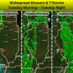


As a storm system moves through the region, widespread showers and t’storms will be likely across the state from Tuesday morning through Tuesday night. Much of this activity will accompany a cold front, as it sweeps west to east across the state during this period.
While an organized severe weather threat is not currently anticipated, a stray strong/severe t’storm cannot be ruled out across Southern Illinois from Tuesday afternoon into early Tuesday night.
Additionally, gusty winds are likely across the state on Tuesday, with widespread peak wind gusts of 30-40MPH expected. Higher peak wind gusts into the 40-45MPH range cannot be ruled out.
#ilwx

Another Mild Week Ahead! 🔥
As has been the story for seemingly weeks now, mild and above average temperatures will continue to be in place this week across the state!
There continues to be no signs of cold or below normal temperatures for the foreseeable near future.
#ilwx

Fall Foliage Update - November 2nd 🍁
High to peak fall foliage color is now estimated to be widespread across Illinois!
Foliage color has changed rapidly over the past week to week and a half, with vibrant foliage color now covering much of the state. 🍂
Enjoy it while it lasts, though. With additional periods of rain expected over the next day or two, and windy conditions likely tomorrow, these high and peak foliage color conditions may not stick around much longer!
#ILwx #fall #autumn #fallfoliage

A few isolated showers may be possible across the state on Monday morning and Monday afternoon, as a trough departs the region.
For Monday night, more organized and widespread showers and isolated t’storms will be likely across Northwestern and Western Illinois, as a new storm system enters the picture.
#ilwx

As a main disturbance/through continues to slide through the region, isolated to scattered showers and isolated t’storms will remain possible across the state through tonight.
#ilwx

⏰ Don’t Forget to Fall Back Tonight! 🍁
Daylight Saving Time officially comes to an end overnight tonight. At 2:00AM Sunday, clocks will “fall back” one hour.
#daylightsavingtime #fallback


As a main disturbance/trough continues to lift through the region, waves of widespread showers and isolated t’storms will be likely across the state from Saturday morning through Saturday night.
#ilwx

As a main disturbance/trough begin to lift into the region, areas of shower and t’storm activity will move across the state from Friday morning through Friday night.
#ilwx

October 27th NOAA Drought Monitor Update… 🏜️
This week’s Drought Monitor update shows a continued expansion and worsening of dry and drought conditions across Illinois.
The ongoing lack of widespread, meaningful rainfall has allowed dry and drought conditions to persist and intensify, particularly across the southern half of the state. With that said, some good news is on the near horizon.

As a storm system continues to push through the region, isolated to widely scattered showers and t’storms will accompany a cold front as it sweeps across the state. This activity is expected to be low in coverage overall.
#ilwx

As a storm system moves into the region, isolated to widely scattered showers and t’storms will accompany a cold front as it pushes across Northern Illinois and vicinity tonight.
#ilwx
