Matt Benz (@MattBenzWeather) header
Matt Benz (@MattBenzWeather) profile picture

Senior Meteorologist @AccuWeather | Former Chief Meteorologist @KTTCTV & @WJFW12 | @UofNorthDakota @UNDATSC Alum | LOVE Weather & Fishing⛈️❄️🎣

Joined April 2013
Photo by Matt Benz (@MattBenzWeather)Photo by Matt Benz (@MattBenzWeather)Photo by Matt Benz (@MattBenzWeather)Photo by Matt Benz (@MattBenzWeather)Photo by Matt Benz (@MattBenzWeather)Photo by Matt Benz (@MattBenzWeather)Photo by Matt Benz (@MattBenzWeather)Photo by Matt Benz (@MattBenzWeather)Photo by Matt Benz (@MattBenzWeather)Photo by Matt Benz (@MattBenzWeather)
7:53am CDT #SPC Day1 Outlook High Risk: over parts of western, central and northern Oklahoma to south-central Kansas spc.noaa.gov/products/outloo…
122
987
488
2,698
644,134
Funnel cloud with the storn in Waseca County where a Tornado Warning is in effect until 4pm. #mnwx
3
25
5
103
62,823
Happy Spring! Took a ride to the north shore to check out the Lake Superior waves crashing into the cliffs. Was not disappointed! Conditions on Tues quickly deteriorated, turned into a proper blizzard. Had to wait that out in a hotel without power and pretty amazing thundersnow at 3am that went for about an hour ❄️⚡️❄️ #spring in #minnesota #big #lakesuperior #waves #naturephotography
4
19
3
136
7,016
We will have several teams out surveying later today. Here's a rough outlook of where we are heading. nwschat.weather.gov/p.php?pi…
18
111
12
349
86,354
The wait is over. ❄️❄️ Central Park recorded the first measurable snowfall of the season this morning, with nearly half an inch as of 5:30 AM. This is latest first measurable snowfall for the season since record keeping began in 1869. #NYwx
32
333
151
1,044
381,399
It took until the 14th, but Central Park has finally touched the freezing mark for the first time this year! Unsurprisingly, this is the City's second mildest start to the year since the late 1860s. Still waiting on the first measurable (0.1"+) snow! #NYwx
3
29
4
65
34,628
Sunrise from over the Charles River. #BostonSunrise #BostonWeather – at Lynnfield, MA
9
39
2,914
Matt Benz retweeted
Incredible plume of blowing dust along cold front captured today in GOES-East 1-min Geocolor Imagery. #cowx #kswx
12
368
40
1,634
1.5” as of 5am at the Duluth NWS!
4
48
20
307
Matt Benz retweeted
The launch of #Artemis I is no longer happening today as teams work through an issue with an engine bleed. Teams will continue to gather data, and we will keep you posted on the timing of the next launch attempt. blogs.nasa.gov/artemis/
1,479
7,675
2,850
27,489
Matt Benz retweeted
LIVE NOW: The #Artemis era of exploration begins today with @NASAArtemis I, the first flight test of the rocket and spacecraft that will take humanity to the Moon. The launch window opens at 8:33am ET (12:33 UTC). teapaw.org/i/broadcasts/1OwGWwajv…
432
4,876
983
11,933
Severe Thunderstorm Warning including Minneapolis MN, Saint Paul MN and Bloomington MN until 12:30 AM CDT – at Richfield, MN
2
15
7
61
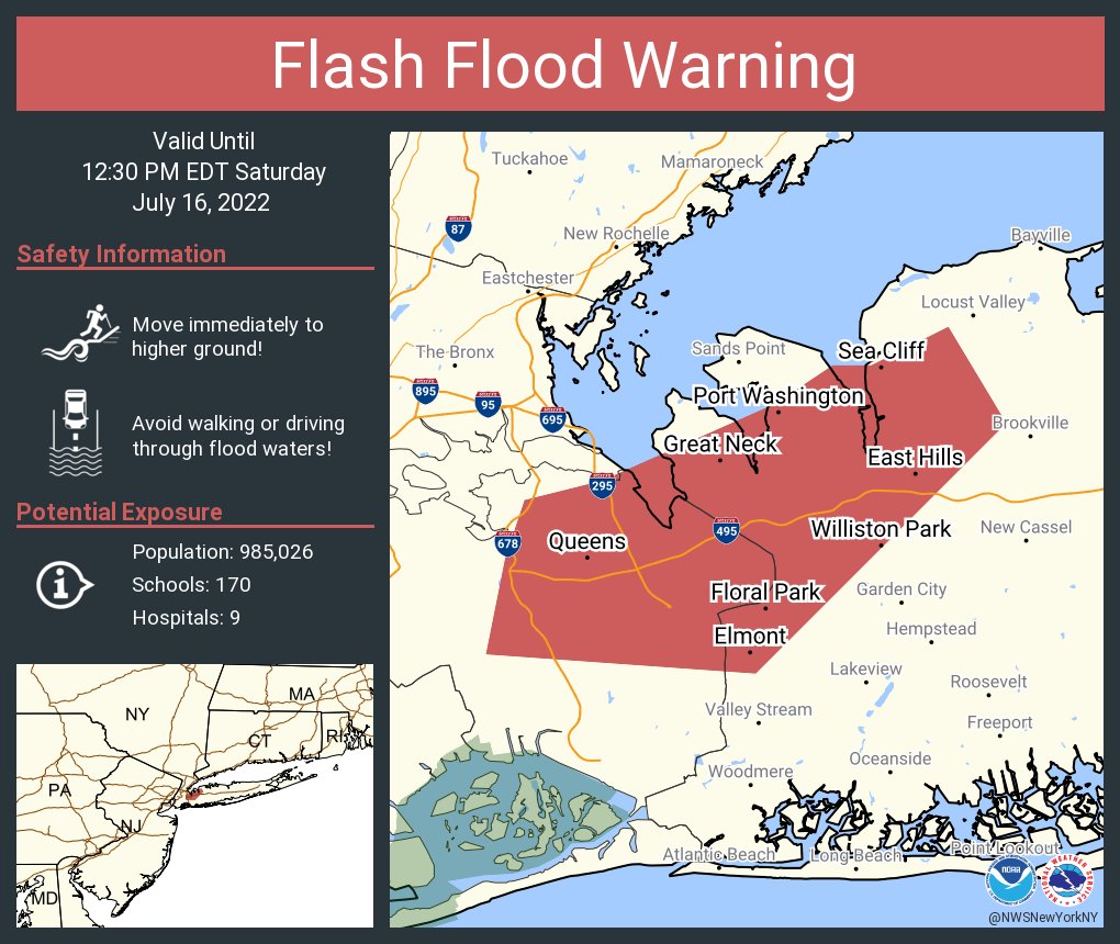
Flash Flood Warning including Queens NY, Elmont NY and Floral Park NY until 12:30 PM EDT
Tropical Storm #Colin Advisory 1: Tropical Storm Colin Forms Near the South Carolina Coast. Tropical Storm Warnings Issued For Portions of the South Carolina and North Carolina Coasts. go.usa.gov/W3H
2
57
16
161
Frosty T. Snowman taking in the views from the summit at sunset Monday. What little remains of this weekend's snow & ice will continue to melt today as sunshine & seasonal temperatures return. Full details at mountwashington.org/experien… #NHwx #NH #mountains #snowman #snow
2
13
4
133
A view of our June-uary weather this morning. The higher terrain of NH and ME will continue to see winter-like conditions through the day and into Sunday evening (June 19, 2022). Elevations above 4500 feet will continue to experience ambient air temperatures close to... (1/x)
4
98
40
340
A heat burst just hit Tracy, MN due to a nearby thunderstorm! The temperature went from 80 to 93 deg (as of 521 am) with a 52 mph wind gust.
9
30
18
220
A severe thunderstorm watch has been issued for parts of Minnesota and Wisconsin until 1 PM CDT – at Minnesota, USA
2
5
This group of images is a look from above at the northward-expanding inundation footprint of the Red River of the North in North Dakota. These images are from the RADARSAT Constellation Mission imagery between April 28 - May 5. @NWSncrfc @NWSGrandForks #TurnAroundDontDrown!
2
16
4
63