

Weather Consultancy. Steph Ball (Ex-Met Office) (Previous Consultant to HM Gov of Gibraltar + Producer/Consultant GBC Weather) 25yrs+ Radio Weather Presenting.
Gibraltar
Joined March 2024
- Tweets3.4K
- Following88
- Followers672
- Likes1.9K






Pinned Tweet
#Gibraltar and for our followers over nearby Spain - #StormBruna #BorrascaBruna - update 06/11
As per our previous posts a deep area of LOW pressure, now named Storm Bruna, develops West of Iberia bringing a change in the weather driving Atlantic weather fronts East, with more widespread rain/ showers across the peninsula, some heavy and locally thundery.
Western areas will see the impact initially, while for Gibraltar and the local area, the first weather front will arrive Sunday night into Monday, an active cold front.
Below are the latest forecast Rainfall Accumulations from #ECMWF seen totting up to next Friday 13th Nov - after a mostly dry but increasingly breezy weekend of Levanter, watch accumulations start to build from Sunday night. 👀
Western areas are forecast to bear the brunt of the rainfall over this period, particularly towards NW Spain and Northern Portugal, with some models suggesting extremely high accumulations and as much as 300-400mm or so.
#Gibraltar - 06/11 - it was a fine end to the week, with a sunny start but giving way to increasing high cirrus clouds, with lighter Westerly winds settling Easterly for the afternoon. Some low cloud/ Levanter developing later during the evening as humidity increased. Max 20.5C.

#Gibraltar : Daily stats 06 Nov
Max 20.5C, with 20.7C on the MeteoGib Weather Station
Min 15.2C
Rain 0.0mm
Wind a light or gentle W'ly, settling E'ly for the afternoon.
#Gibraltar - 06/11 - a lovely sunny view of the Rock from #LaLinea early this morning, before all the high cirrus cloud began to invade the skies - at 4:30pm, the temperature has reached 20.7C so far on the MeteoGib Weather Station, with 21C at the Airport in a gentle Easterly.


#StormBruna #BorrascaBruna - 06/11 - latest RGB Satellite loop shows Storm Bruna clearly, winding up over the Atlantic to the West of Iberia.
#Gibraltar
#Gibraltar - 06/11 - another lovely sunny and colourful shot from this morning, looking across Rosia Bay towards the Parson's Lodge - photo thanks to MeteoGib follower Brenda Ocana.
#Bougainvillea #Mediterranean

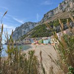
#Gibraltar - 06/11 - a beautiful view of Catalan Bay this morning as some of that high cirrus cloud began to arrive - photo thanks to MeteoGib follower Darren @dazgrech - at 12:30pm, as forecast, the wind has now flipped to Easterly and it's 19C.

#Gibraltar #Weather - 06/11
A fine day with high cloud increasing making the sunshine hazier or spoiling it, while a switch from a light or gentle Westerly to East or East-Southeasterly for the afternoon is expected to see some patchy low cloud/ Levanter develop later. 20 or 21C.
#Gibraltar #Weather - 06/11 - for this evening and overnight - high cloud lingering and with increasing low cloud rolling in from the Alboran, perhaps some misty low cloud. A humid night of Levanter in gentle or moderate East to Northeasterly winds, 17C.

#Gibraltar - 6am, 06/11 - some thicker high cloud moved through during the night giving way to some clearer skies with patchy high cloud lingering, and light or gentle West to Southwesterly winds - the temp a touch cooler than this time yesterday and 15-16C with humidity at 87%.

#Gibraltar - 05/11 - a stunning shot of this evening's #sunset from MeteoGib follower Dino @DinoChincotta - on a day which saw cloud come & go giving just the odd shower late morning, with sunshine too, turning hazier later as high cloud spread in. Winds were light, Max 22.5C.

#Gibraltar and our followers over nearby Spain - 05/11
AEMET has now named #StormBruna #BorrascaBruna as the deep LOW which we mentioned in our earlier posts, which will bring a change in weather across the peninsula. 👇

🌀 A partir del sábado nos afectará la borrasca Bruna.
⛈️ Lluvias fuertes y persistentes acompañadas de tormentas.
🌬️ Vientos intensos.
🌊 Temporal marítimo.
Nombrada por el servicio meteorológico portugués, @ipma_pt, dejará tiempo adverso tanto en España como en Portugal.

#Gibraltar : Daily stats 05 Nov
Max 22.5C, with 21.9C on the MeteoGib Weather Station
Min 15.9C
Rain 0.0mm, with the odd shower giving 0.2mm OV
Wind W or SW'ly, mainly light or gentle, becoming variable later.
#Gibraltar - 05/11 - a beautiful view/ clouds snapped from Rosia Bay late afternoon - photo thanks to follower Terence Ocana.

#Gibraltar #CampionPark - 05/11 - a lovely lunchtime view with sunny spells, with cloud still coming & going through the afternoon - at 3:30pm, the temperature has reached 21.6C so far on the MeteoGib Weather Station and 22C at the Airport.


#Gibraltar and for our followers over nearby Spain - a look ahead - 05/11
While we saw little from the recent showers pushing up during the last few days, as we posted earlier in the week, a change is on the way through Sun into next week as a deep LOW develops over the nearby Atlantic.
This is forecast to drive weather fronts East bringing more widespread rain/ showers across the peninsula, some heavy and locally thundery. Below is the latest Rain forecast from the UK Met Office out to midweek.
Firstly for #Gibraltar and the local area, for Fri and Sat, we should escape dry with winds returning to Easterly/ Levante and picking up into the weekend.
For Sun, a breezy/ blustery Levanter continues and we may see the chance of some showers increasing, but it's really overnight and heading into Mon that the first of those weather fronts is expected to arrive.
The Rain Probability chart for the Rock, shows the increased rain signal heading into early next week, with the latest #ECMWF Rain Anomaly chart indicating a wetter than average week, for Mon 9th to Mon 16th, for a large part of Iberia but especially towards the W/ S. 👀


