

Official X account for @NOAA's National Weather Service. A list of official NWS accounts can be found at https://xitter.cf/t.co/nG1wK2Kcru
- Tweets47.2K
- Following323
- Followers3.2M
- Likes10.8K





ALT This graphic displays Severe Thunderstorm watch number 689 plotted on a map. The watch is in effect until 9:00 PM MST. The watch includes parts of Arizona. The threats associated with this watch are a couple tornadoes possible, scattered hail up to two inch size possible and scattered gusts up to 70 mph possible. There are 5,003,542 people in the watch along with 1416 schools and 63 hospitals.


ALT A Moderate Risk ERO is in effect tomorrow across portions of Southwestern Colorado. Rainfall totals of 2-3 inches, local 5 inches, atop snow melt on higher terrain will allow for locally significant flash and riverine flooding. The Four Corners may see scattered flash flooding.





ALT Graphic promoting a NEDTalk about El Niño with the NOAA logo in the bottom right-hand corner.


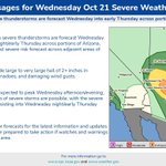
ALT National Weather Service graphic warning of scattered severe thunderstorms across Arizona Wednesday Oct 21, highlighting large 2+ inch hail, isolated tornadoes, and damaging winds with highest risk near Phoenix, Flagstaff and Lake Havasu City; monitor forecasts.


ALT Map and infographic detailing strong wind, high surf, and coastal flood impacts late this week for Southwest Alaska. Watches In Effect (Fri AM – Sat AM): Kuskokwim Delta & N. Bristol Bay: High Wind Watch (S/SE 35–50 mph, gusts to 70 mph; 60–80% chance of >60 mph winds). Aleutians East Borough (Cold Bay, King Cove): High Wind Watch (SE 40–50 mph, gusts to 75 mph; 40–60% chance of ≥75 mph winds). Kuskokwim Delta Coast (incl. Kipnuk & Kwigillingok): Coastal Flood/High Surf Watch (Fri AM – Fri night). Water levels 2–3 ft above average tide line; low-lying coastal flooding and erosion possible. Actions: Secure loose outdoor objects, prepare belongings, evaluate travel plans, and monitor updates.


ALT A moderate storm is expected to impact Southern California Wednesday through Thursday. Rainfall totals are expected to generally range from 0.5 to 1.5 inches except 1.5 to 3 inches across south facing mountains/foothills. Minor flooding and debris flows are possible especially near recent burn scars. Peak timing for most locations will fall into the late Wednesday morning through late Thursday morning timeframe. Isolated to scattered thunderstorms are possible bringing potential hazards such as cloud-to-ground lightning, heavy downpours, gusty winds, small hail, and even isolated waterspouts.

ALT A Slight Risk (yellow, at least 15% chance) covers much of Arizona, including Phoenix, extending into southern Utah and western New Mexico. A separate Slight Risk area affects portions of coastal Southern California. A broader Marginal Risk (green, at least 5% chance) extends across portions of California, Nevada, Arizona, Utah, and New Mexico.

ALT The Slight Risk shifts eastward, covering portions of eastern Nevada, southern Utah, much of Arizona, and western New Mexico, including Phoenix. A broader Marginal Risk encompasses surrounding areas of Nevada, Utah, Arizona, and New Mexico, with a separate area near coastal Southern California.


ALT National Weather Service logo with text: "The National Weather Service Presents Weather101" Schedule: This week’s classes (times are ET): Mon, Oct 19 | 8 pm: Winter Weather Tue, Oct 20 | 8 pm: Storm Surveys Wed, Oct 21 | 8 pm: Weather Balloons Thu, Oct 22 | 8 pm: Satellites Fri, Oct 23 | 11 am: Lightning Registration & Details: To register and for a full list of classes, visit weather.gov/ohx/weather101 These ONLINE classes are FREE and open to people of all ages Each class is hosted by a NWS meteorologist Classes run 1 hour or less including a Q&A session

ALT Latest Key Messages for the October Nor'easter. A non-tropical low pressure system will develop and intensify well off the North Carolina coast early this week before slowly tracking north and exiting the region by late week. The storm will likely bring long-duration coastal impacts to portions of the Mid-Atlantic, especially for the North Carolina Outer Banks. Persistent and strong onshore winds will result in moderate coastal flooding, dangerous marine conditions and beach erosion, especially at high tide cycles, through mid-week from southern New Jersey through the North Carolina coast. The storm is likely to bring wind gusts in excess of 45 mph, most likely across the Outer Banks region and the Virginia Tidewater. Exact details on the magnitude and location of the impacts through the week are still evolving. Check weather.gov regularly for the latest updates.


ALT Sunday, October 18, 2026. 3:52 AM ChST Typhoon Champi (29W) The National Weather Service in Tiyan Guam has issued a * Extreme Wind Warning for... Southern Guam in Guam... * Until 530 AM ChST.

