

Extreme meteorologist, inventor and storm chaser intercepting the most powerful storms on the planet. I'm driven to push the science and its education forward.
Golden, CO
Joined February 2009
- Tweets114K
- Following25.3K
- Followers88K
- Likes59.6K




Pinned Tweet
The wait is almost over...
Never Stop Chasing premiers later this week across hundreds of theaters in the United States!

Reed Timmer, PhD retweeted

Large stovepipe tornado captured north of Heber-Overgaard, AZ 15 minutes ago with @RealDLScales

Live emergency update on flash flood warning in Moenkopi, Arizona with severe storm with #tornado possible tag approaching
#stormchasing #Dominator @accuweather
Chasing an Arizona tornado and gorilla hail threat in complex terrain. Watch the ground scrubber wall cloud after the hail core punch on this monster supercell @nittotire terra grappler G3s dominate the treacherous road conditions on I40 near Williams Arizona #stormchasing #dominator
HOOK SLICE of monster supercell with ground scraper wall cloud and goof ball hail west of Williams, Arizona
Live emergency update on #tornado watch issued for a large part of central and northern Arizona including Flagstaff. We are targeting a cluster of supercells now southwest of Williams
Possible #tornado observed from LONG RANGE with the Flagstaff, Arizona supercell
FLAGSTAFF, ARIZONA! Take cover immediately! A dangerous #tornado warned supercell is approaching NOW from the southwest!

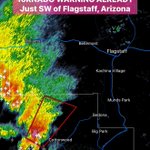
TORNADO WARNING already southwest of Flagstaff, Arizona this morning.
This is out first target storm!

TWO DAYS IN A ROW OF RARE ARIZONA #TORNADO THREAT!
This is the first time ever that Phoenix and Flagstaff are included in a day 2 enhanced risk, with hatch area for gorilla hail and 5% tornado probabilities. It could turn in to an even more rare two-day tornado risk in the desert.
We will be activating storm chase mode for this rate tornado outbreak threat.

LIVE EMERGENCY UPDATE on the first-ever day 2 enhanced risk for severe weather in Arizona tomorrow.
A desert #tornado outbreak is certainly possible tomorrow afternoon and evening including Phoenix to Flagstaff to Page, Arizona into southern Utah.
Storm chase mode will be activated
DESERT #TORNADO OUTBREAK POSSIBLE tomorrow afternoon and evening across parts of Arizona into southern Utah!
A potent upper-level trough will punch east from off southern California with a warm sector energized by Pacific moisture off the Super El Nino. Short-range models show the potential for long-track supercells with tornado potential especially north of Phoenix.
This is a textbook fall tornado producer for the Desert Southwest. Storm chase mode will be activated after my speaking event today

Sometimes you have no choice but to activate flash flood mode!
Desert #tornado and flash flood threat tomorrow in Arizona
#stormchasing
Reed Timmer, PhD retweeted

That time of the year again! I should update it but I’ll stick with the original. #ripgizmo

We are planning to fix up Dominator 1 and 2 this winter so we can chase with all three Dominators in 2027!
I will be posting behind-the-scenes videos of the rebuilds to Patreon and also Twitter subscribers.
If interested my new Patreon page is here: patreon.com/ReedTimmer?utm_c…
The winds of a tornado subvortex can reach up to 4 TIMES that of the parent #tornado. That means an EF2 multiple vortex tornado like this one could generate up to 400 mph winds inside a violent subvortex. This is why we built the Dominators - to survive and measure the winds inside the subvortices of a tornado.
Watch this intercept of the Windthorst, Texas tornado
