Independent Meteorologist Michael Mojarro, A trusted source for Southern California microclimate weather forecast for 25years&counting!

Palm Springs, CA
Joined September 2012
SoCalWeather.net retweeted
It's looking like a wet Halloween weekend for #SoCal. Here is the 6-10 Day Outlook, indicating chances for above normal rainfall for next weekend. * Moderate to high confidence in measurable rain * Low confidence in exact timing and amounts #CAwx
12
67
9
498
43,707
1st dusting of snow of season in upper parts of Big Bear tonight can barely see the white on the dirt ! #CAwx #Snow #BigBear
1
3
1
46
2,218
Potent Thunderstorm currently impacting OC. Shows just how unpredicted cutoff lows can be! #CAwx #Thunderstorms #OC
4
4
65
3,008
Raining good in Palm Springs witg snow in our mountaibs above 7500ft due to unexpected wrap around moisture frok our departing low.
1
35
1,313
SoCalWeather.net retweeted
Too soon for snow? The wild October storm that brought hail, flooding, wicked winds and thunderstorms to SoCal also left a wintry treat. AIR7 was up over Mt. Baldy with the slopes sporting snow. The big weather change coming - This morning at 6 from ABC7 abc7.com/58983
4
22
8
123
14,819
Snow falling currently at top of Big Bear resorts! #CAwx #Snow #BigBear
2
2
1
45
1,330
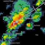
A potent Thunderstorm is heading into Temecula and Murrieta currently with hail and maybe even a slight chance of a 🌪 #CAwx #Thubderstorm #Temecula #Murrieta #Hail
5
2
36
1,644
SoCalWeather.net retweeted
A special weather statement has been issued for Mira Loma CA, Glen Avon CA and Pedley CA until 1:30 PM PDT
1
14
4,187
** Scattered Showers and a Few Thunderstorms to continue through Friday afternoon* Our Alaskan low continues to spin to our north and will develop a new cutoff low over the region this afternoon. This will bring another increase of showers and Thunderstorms later this morning and afternoon as daytine heating peaks, mainly over and west of our mountains. Showers will continue inland and over San Diego into Friday. There will be plenty of sun breaks in between showers. Additional rainfall will be highly variable generally .10-.50"+with LA/IE likely seeing the highest amounts bringing our storm total to most areas in the .50-1"+ range. Highs today and tomorrow we'll below normal in the 60s&70s for most areas. Look for a nice weekend with highs still below normal. #CAwx #Rain #Thunderstorms #ElNino #LosAngeles #BigBear #SanDiego
2
10
73
2,805
There is an increasing chance of an unusually wet Halloween for southern California. One or more low pressure systems interacting with enhanced Pacific moisture favor above-normal precipitation across California and the Southwest from Oct 29-Nov 4.
1
60
6
351
15,100
**Final Forecast Possible Rain&High Mountain Snow 12pm Wednesday-6pm Thursday ** -West of the Mountains- SB/VTU: 1-2"+ LA/OC: 1-2"+ IE: .75-2"+ SD: .50-1.25"+ -Mountains- Rain: 1-3" Snow: 6-12"+ abv 9000ft(peaks) 3-6" abv 8000ft Dusting abv 7000ft -Deserts- High: .25-.50" Low: .10-.25" #CAwx #Rain #Snow #October #ElNino #Thunderstorms #LosAngeles #BigBear #Temecula #SanDiego
4
3
48
2,421
***Early Season Alaskan Storm to bring rain&Thunderstorms to region Wednesday-Thursday** All eyes on what will be a pretty potent Early season winter storm with a few mountain showers today ahead of the system followed by increasing rain and Thunderstorms Wednesday afternoon through Thursday. This system will tap into our record warm ocean waters from El Nino that'll combine with colder Alaskan air for a good shot of widespread Thunderstorms across the region Wednesday night through Thursday. Some of these storms may turn Severe with waterspouts/weak tornadoes possible along the coast. Computers have continued to increase potential rain amounts with anywhere from 1-2" across LA county and the IE with a bit less further south and over our deserts. There could be some flooding/debris flows along rescent burn areas. Snow levels will be mostly above 8000ft with our peaks seeing Several of inches of October snow. Showers and Thunderstorms will linger through Thursday evening especially Inland. Stay tuned for a more detailed rainfall forecast! #CAwx #Rain #Thunderstorms #Snow #ElNino #LosAngeles #Temecula #BigBear #SanDiego
1
8
75
2,858
SoCalWeather.net retweeted
The ocean off San Diego and LA has been running a FOOT higher than normal all month... and El Niño is to blame. It’s because of something called a Kelvin wave. El Niño weakens the trade winds, so warm water near the equator sloshes east across the Pacific as a giant, slow-moving bulge. When it hits Mexico, it turns and rides north up the coast, raising sea levels and warming the water as it goes. More of these waves are on the way, and with rain moving into SoCal Wednesday and Thursday, coastal flooding can happen a lot easier than usual.
19
81
8
534
30,427
**Updated Possible Rain&Mountain Snow Amounts 12pm Wednesday-9am Friday** A potent Alaskan storm for October standards will bring periods of rain and Thunderstorms to the region mid this week with Thursday bring the day we see the heaviest activity as well as Thunderstorms as the low taps into our warm waters offshore. Snow levels will start above 9000ft Wednesday then fall to 7000-8000ft Thursday with some light amounts at resorts possible. Highs will fall to 10+ degrees below normal. Look for showers to taper off inland by Friday morning. Stay updated as details become more clear. A little tease of what looks to be a wet and early wet season! -West of the Mountains- SB/VTU: .50-1.50"+ LA/OC: .50-1.50"+ IE: .35-1.25"+ SD: .25-.75"+ -Mountains- Rain: 1-3" Snow: 6-12"+ abv 9000ft 3-6" abv 8000ft Dusting-2" abv 7000ft -Deserts- High: .25-.50" Low: .10-.25" #CAwx #Rain #Snow #October #Thunderstorms #LosAngeles #BigBear #SanDiego
2
11
111
5,417
SoCalWeather.net retweeted
Have you seen any rain? Scattered showers are moving over LA County. Very dry air below the clouds is likely causing most of the rain to evaporate before it reaches the surface, but let us know if you've seen rain! More widespread rain is on the way next week 👀🌧️ #LARain #CAwx
13
31
1
196
18,927
**1st Forecast Possible Rain&Mountain Snow Amounts 9pm Tuesday-6pm Thursday ** An early season Alaskan winter storm is expected to impact SoCal between Tuesday night and Thursday. Computers have been consistently increasing possible rain amounts with this system as it may tap into some tropical moisture from another dying Hurricane off Baja and our warm waters. This combined with cold air in the storm could bring scattered Thunderstorms as well. Looking to be a pretty significant winter storm for October. Snow leveps will start near 9000ft then bottom out near 6000ft Thursday during the colder portion of the storm. Flooding in rescent burn scars looks possible so residents there need to pay close attention in coming days! -West of Mountains- SB/Ventura County: .50-1.50"+ LA/OC: .75-2" IE: .50-1" SD: .25-1" -Mountains- Rain: 1-3"+ Snow: 1-2ft abv 9000ft 6-12"+ abv 8000ft 1-3" abv 7000ft Dusting abv 6000ft -Deserts- High: .25-.75" Low: .10-.25"+ #CAwx #Rain #Snow #ElNino #Thunderstorms #Floods #LosAngeles #Riverside #BigBear #SabDiego
4
13
144
7,353
**A few showers possible inland today, weakening Santa Anas and widespread rain mid next week** Very interesting weather set up this morning. Although weakening Santa Anas continue , A subtropical low to pur south has drawn uo moisture into San Diego county and our deserts this morning and actually brought a Thunderstorm and some sprinkles to San Diego this morning. Clouds and sprinkles will continue to be possible in those areas today but with dry air at surface most rain won't reach the ground. Santa Ana winds are pretty much over with just some lingering gust in favored areas. Highs will cool down back to normal by tomorrow and eventually below normal Monday with 70s&80s west of the mountains. All eyes on another October winter storm next week with widespread rain and mountain snow expected for the region Wednesday-Thursday. Current thinking is .25-1" of rain possible west of the mountains with snow levels between 6000-8000ft with a good shot of some wet October snow around Big Bear by Thursday. Highs will fall to 10-15degrees below normal only in the 60s for most areas so get tjose jackets ready more details to come! #CAwx #Rain #Snow #Fall #LosAngeles #SanDiego #BigBear #Temecula
2
9
95
5,043
**Moderate-Strong Santa Ana Winds expected through tomorrow, rain returns next week** Now looking like the 1st Santa Ana winds of season will be a Moderate-Strong event later today through tomorrow, especially in LA county with winds in favored areas gusting up to 70mph, but most areas will see gust in the 30-50mph range over and west of our mountains. Fire danger looks high in LA county but much less extreme everywhere else where heavy rains fell a few days ago keeping vegetation moist. High will be 10+ degrees above normal west of the mountains with 80s&90s but near normal in our mountains and deserts thanks to cold air advection . Look for winds to die down Friday afternoon and for cooler, calmer conditions this weekend. Long range continues to show a major pattern shift next week with a cold Alaskan trough bringing chances of rain and mountain snow between Tuesday &Wednesday next week as well as high well below normal as typical October weather continues. #CAwx #SantaAnaWinds #Rain #Snow #LosAngeles #BigBear #SanDiego
1
54
2,551