

Northeast Tennessee coverage on short and long range weather, 7-Day forecasts for the Tri-Cities, model discussion, etc. Snow is the best kind of weather.
Joined December 2020
- Tweets28.9K
- Following932
- Followers4.8K
- Likes20.7K
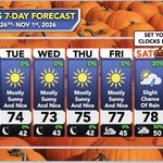







Just outside of Johnson City, TN today.
(October 25th, 2026)
Definitely some color, but certainly running behind schedule.


The extension of the Pacific Jet that is one of the El Niño trademarks we all know and love is about to get rolling in early November and begin to shuffle the drier pattern we’ve been stuck in over the Tennessee Valley. Enjoy this week. Next weekend the clocks roll back, the jet rolls in, and the rain finally comes down again over the Tennessee Valley.
97-98 gets a lot of hate on the East Coast but interior (Ohio/TN valleys in part at least did very well with 1 or 2 whoppers

Euro first week of December vs 3 strong el ninos 1982,1997,2015. What is wild is 1997 looked like a great start, but its the other two that had block buster eastern storm. 97-98 here was one of our snowiest winters in 30 years ( we have been way below average) but a stinker on the coast. Louisville did have their biggest storm ever that winter


StormTrackerSacher retweeted

Projected snow or ice amounts can’t tell the whole story. The Winter Storm Severity Index shows how the winter weather will actually impact your area. The probabilistic version goes even further, showing best and worst case scenarios and the likelihood of each impact level. ❄️🧊

ALT weather.gov/wssi-p
StormTrackerSacher retweeted

Delightful (adj.): Highly pleasing.
The weather this weekend will be absolutely delightful!
Expect clear skies, with highs in the upper 60s to low/mid 70s, and lows in the upper 30s to 40s. Enjoy! See less


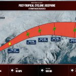
Post-Tropical Cyclone Josephine is about 235 miles east-southeast of Nantucket Massachusetts. Winds 65 mph. Josephine becomes a powerful extratropical low. A gradual turn toward the east is forecast on Friday and into the weekend. Moving northeast at 17 mph.


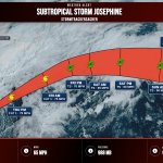
Subtropical Storm Josephine is about 200 miles southeast of Nantucket Massachusetts. Winds 65 mph. Josephine moving northeastward across the northwestern atlantic. Expected to become a powerful extratropical cyclone this afternoon or tonight. Moving northeast at 12 mph.


Awesome breakdown!
And don’t go telling your cousin’s pet grandma or…something like that 😆
This WINTER Will Bring HUGE Snowstorms.. But For Who?!
youtu.be/-EQe1vaCH_o

