

Chief Meteorologist (CBM) at WREG in Memphis. Husband and Dad. Chicago native. Valpo grad.
Memphis, TN
Joined January 2012
- Tweets9.5K
- Following1.3K
- Followers5.4K
- Likes15.1K






4:30pm Wednesday: Just like we talked about yesterday, exact track is everything when it comes to weekend impacts here in the Mid-South from Isaias.
The most likely scenario at this point is a storm that comes up through Alabama rather than Mississippi. This leads to a pretty significant difference in rain and wind in areas like NE Mississippi compared to eastern Arkansas. It's still early, and the specific track isn't locked in yet, but if the trend holds we'll be able to start nailing down the weekend forecast and rain totals by tomorrow.


It's still a bit too early to talk potential impacts from Isaias here in the Mid-South. A storm staying farther east (more likely if slower to develop) would mean very little impact for us locally. Something further west coming up through Mississippi (more likely if it strengthens quickly) would bring us heavy rain and gusty winds over the weekend.
We'll keep you posted!


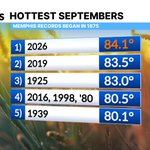
September now in the books, and no surprise it was our hottest on record in Memphis since records began in 1875.


Relief is in sight! We'll finally get some more typical mid-September temperatures by the middle of next week, but first a smokin' hot weekend with more record highs in jeopardy.

Officially a new daily record of 99° in Memphis today. More records in jeopardy right on through this upcoming weekend. Hotempber continues! 🔥
Still on track for a 'cooldown' to near normal next week.


2:25PM Saturday: Isolated storms will be diving in from the northwest late this afternoon through this evening. Some will have the potential to produce damaging wind gusts. Severe thunderstorm watch in effect for the mid-south until 10 PM. 

WEEKEND SCORCHER 🔥
Our heatwave peaks this weekend before some gradual cooling arrives next week with isolated storm chances. Hang in there!


The heat keeps building the rest of this week, peaking in the triple digits for many this weekend. No signs it will let up much through at least the middle of next week.
Is it Fall yet?


One more excessively hot steambath to get through on Tuesday. A backdoor front will get temperatures back to normal with less humid conditions Wednesday-Friday. As this front slides by expect some scattered downpours Tuesday night through Wednesday morning.

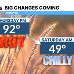
Turning a bit cooler and less humid for the next few days across the Mid-South. Enjoy it while we have it!

