

A coalition of law enforcement, fire service, health care, public health, public works, EMS, military, and partner agencies from Cape Cod and Nantucket.
Barnstable, Massachusetts
Joined January 2014
- Tweets1.3K
- Following132
- Followers1.1K
- Likes125
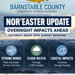


Nor’easter Update 🌧️💨
Strong winds peak overnight into Sunday morning. A Flood Watch is in effect through 2 AM Tuesday, with heavy rain and localized flooding possible. Coastal impacts continue through Sunday evening.
Stay weather-aware, Cape Cod.
#CapeCod #NorEaster

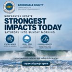
🌧️ Nor’easter Update: Strongest impacts expected today to early Sunday.
High Wind Warning: gusts 45–60 mph possible Coastal flooding/beach erosion possible
Heavy rain/localized flooding
Outages remain relatively low so far, but we’re not through it yet. capecod.gov/prepare

Could your household manage for several days w/o power, H20, or easy access to stores?
Build your emergency kit. Water, food, medications, flashlights, batteries & chargers are a great start.
capecod.gov/Prepare capecod.gov/flood-ready
#ReadyMA

Air Quality Alert: MassDEP has issued an Air Quality Alert for Barnstable County through midnight Thursday due to fine particulate pollution from Canadian wildfire smoke. Sensitive groups should limit prolonged outdoor activity. Check current conditions: airnow.gov/

🌀 It's Hurricane Preparedness Week! Cape Cod, let's be ready. Make a plan, build a kit, know your evacuation zone, and stay informed. Visit capecod.gov/prepare and follow Barnstable County, your town, and trusted media sources for updates. #CapeCod

☀️ Heat Advisory remains in effect for Cape Cod through July 4. Stay hydrated, take breaks in A/C, avoid strenuous activity during peak heat, and check on neighbors.
Cooling centers: capecod.gov/cooling-centers
#CapeCod #HeatSafety
🤖 Made with AI

☀️ Barnstable County Emergency Management has compiled heat safety resources and a list of cooling centers open during this week's hot weather and holiday weekend. Cooling center locations + hours vary by location. To be updated as new info is available. loom.ly/nDRiA9w
🤖 Made with AI

⚠️ Heat Safety Reminder
Much of inland Massachusetts is under an Extreme Heat Watch thru weekend. Cape Cod is not included in the watch, but hot + humid conditions can still lead to heat-related illness. Stay hydrated. Stay cool. Check on others.
capecod.gov/EmergencyManagem…
#CapeCod
🤖 Made with AI

Hurricane season is here. It only takes one storm to impact Cape Cod and the Islands. Now is the time to review your emergency plan, build an emergency kit, know your risks, and stay informed. Learn more: capecod.gov/emergencies
#CapeCod #EmergencyPreparedness #StormReady

Cape Cod Shelter Update
➡️ Shelter travel is permitted under the ban, but roads remain hazardous — travel only if necessary.
Open:
➡️ DY Regional HS – opens 8 PM
➡️ Barnstable Intermediate School – open
➡️ Nauset – now closed capecod.gov/bcrepc

⚡ Power outages reported across Cape Cod due to heavy snow & strong winds.
Report outages:
Eversource 1-800-592-2000
National Grid 1-800-465-1212
Stay off roads. Avoid downed wires.
Updates: capecod.gov/bcrepc

Barnstable County: Shelters Open
• Nauset Regional High School (Eastham)
• Barnstable Intermediate School (Hyannis)
Travel is dangerous. Stay home unless leaving for safety.
Shelter Map & Important Information: capecod.gov/shelters

Regional shelters now open on Cape Cod
➡️Nauset HS (Eastham)
➡️Barnstable Intermediate (Hyannis)
Details: capecod.gov/bcrepc

Blizzard Update – 5:30 PM Feb 22
Barnstable County has released a new storm update.
Blizzard conditions expected overnight–Mon.
Worst conditions Mon morning–early afternoon.
2 regional shelters open tonight. See locations and all details:
capecod.gov/bcrepc

Storm Update: Read Barnstable County Situational Report #002. Blizzard Warnings in effect for Cape Cod & Martha’s Vineyard. Major storm expected Sun PM–Mon with heavy snow, strong winds, power outage risk & dangerous travel.
Prepare now loom.ly/SVWSV40

Feb. 22, 2026 | 6:00 AM — Cape Cod Storm Update
Major winter storm expected tonight–Mon.
⚠️ Winter Storm Warning: Cape Cod
⚠️ Advisory: Nantucket
🌊 Coastal Flood Warning
💨 Wind gusts up to 60–70 mph
🚗 Travel may become difficult to impossible
Updates capecod.gov/bcrepc

Storm Update – 3:30 PM 2/21
Blizzard Warning for Cape & Vineyard Nantucket under Winter Storm Watch.
➡️ 12–18” heavy wet snow possible ➡️ Peak snow after 2 AM Mon–PM ➡️ Gusts 40–60 mph, isolated ~70 mph ➡️ Coastal flooding possible Mon AM high tide
capecod.gov/bcrepc

Major winter storm possible Sunday night into Monday on Cape Cod.
➡️ 12–18” heavy wet snow possible
➡️ Gusts up to 70 mph possible
➡️ Coastal flooding possible
➡️ Potential multi-day power outages
Prepare now. Avoid travel during peak impacts Monday.
capecod.gov/bcrepc

Confidence increasing for a coastal storm impacting Cape Cod Sun PM into Mon.
NWS has issued: ⚠️ Winter Storm Watch ⚠️ High Wind Watch ⚠️ Coastal Flood Watch
Heavy wet snow, strong winds & coastal flooding possible. Heaviest impacts Monday.
Latest updates capecod.gov/bcrepc


