

Research scholar (Ph. D.) #Agrometeorology, GBPUA&T, Pantnagar. #Worked as Meteorologist(Agril.) at ICAR-NRRI, Cuttack, Odisha #(Tweets are personal)
Cuttack
Joined August 2021
- Tweets7.3K
- Following483
- Followers1.1K
- Likes5.4K




Bhubaneswar recorded 21.4c as maximum temperature on 20 Nov, this is the lowest day temperature in November after 1975.
Data: IMD
???? ଲୋକ ମାନେ ମତାମତ ଦେଇପାରିବେ.

ମୋ ମତରେ ଆଗାମୀ ବାତ୍ୟା ଓଡ଼ିଶା ଉପକୂଳ ଆସିଲା ବେଳେକୁ ଏକ ଗଭୀର ଅବପାତ/ଅବପାତ ଥିବା ସମ୍ଭାବନା.
ବର୍ତମାନ ର ଗତିପଥ ଅନୁସାରେ ଗଜପତି, ଗଞ୍ଜାମ,ପୁରୀ, ଖୋର୍ଦ୍ଧା, ଜଗତସିଂହପୁର, ନୟାଗଡ, କନ୍ଧମାଳ ଜିଲ୍ଲା ରେ 19-20 ମଧ୍ୟରେ ପବନ 50-60/70କିମି ପ୍ରତି ଯାଇପାରେ ଓ ଅନ୍ୟ ସଂଲଗ୍ନ ଜିଲ୍ଲା ମାନଙ୍କ ରେ 40-50/60କିମି ଯାଇପାରେ.
ବର୍ଷା

3
15
1,118

🌀 Cyclone #AKVAN Update:20
✅Deep convection has shifted towards the northeastern sector, leaving the Low-Level Circulation Centre (LLCC) exposed. Vertical wind shear, asymmetric convection and a broad, poorly organised circulation are restricting inner-core development.

✅Maximum sustained wind speed is likely to be 60–70 km/h, with gusts reaching 80 km/h.
#CycloneAKVAN #Odisha #Gopalpur #WeatherUpdate
1
2
208
ଏହା ଏକ ଦୁର୍ବଳ ବାତ୍ୟା ତଥା ଗଭୀର ଅବପାତ ରୂପେ ସ୍ଥଳ ଭାଗ ଅତିକ୍ରମ କରିବା ସମ୍ଭାବନା.
ଧନ୍ୟବାଦ
ମୋ ମତରେ ଆଗାମୀ ବାତ୍ୟା ଓଡ଼ିଶା ଉପକୂଳ ଆସିଲା ବେଳେକୁ ଏକ ଗଭୀର ଅବପାତ/ଅବପାତ ଥିବା ସମ୍ଭାବନା.
ବର୍ତମାନ ର ଗତିପଥ ଅନୁସାରେ ଗଜପତି, ଗଞ୍ଜାମ,ପୁରୀ, ଖୋର୍ଦ୍ଧା, ଜଗତସିଂହପୁର, ନୟାଗଡ, କନ୍ଧମାଳ ଜିଲ୍ଲା ରେ 19-20 ମଧ୍ୟରେ ପବନ 50-60/70କିମି ପ୍ରତି ଯାଇପାରେ ଓ ଅନ୍ୟ ସଂଲଗ୍ନ ଜିଲ୍ଲା ମାନଙ୍କ ରେ 40-50/60କିମି ଯାଇପାରେ.
ବର୍ଷା
8
384

✅ଜିଲ୍ଲା ଭିତ୍ତିକ ପ୍ରଭାବ
✅ବର୍ଷା ର ପ୍ରଭାବ 19-21ସକାଳ ପର୍ଯ୍ୟନ୍ତ ବାତ୍ୟା ଟ୍ରାକ ର ସଂଲଗ୍ନ ଓ ଡାହାଣ ପାର୍ଶ୍ଵ ର ସମସ୍ତ ଜିଲ୍ଲା ମାନଙ୍କ ରେ ଅଧିକ ରହିବ.
✅ପବନ ର ପ୍ରଭାବ
✅70-80/ଝଟକା 90କିମି ପ୍ରତି ଘଣ୍ଟା: ଗଞ୍ଜାମ, ପୁରୀ, ଖୋର୍ଦ୍ଧା ଜିଲ୍ଲା ର ଉପକୂଳ ଅଞ୍ଚଳ ରେ 60-70/ଝଟକା 80କିମି ଆଭ୍ୟନ୍ତରୀଣ ଅଞ୍ଚଳ ରେ.

ମୁଁ ଗତ କାଲି ଓ ଆଜି ମୋତେ ପଚାରିଥିବା ସମସ୍ତ ଭାଇ ଓ ଭଉଣୀ ଙ୍କ ଉତ୍ତର ମୋ ସୀମିତ ଜ୍ଞାନ ଅନୁସାରେ ରଖିଛି.
ଧନ୍ୟବାଦ 🙏🏻
My dear and near x family members due to travel and attending one conference, i was unable to update timely from yesterday about the forecast of ongoing cyclone Akvan. But now onwards i am free, will update when ever it will be required.
Sorry for any inconvenience from my side🙏🏻
8
386
My dear and near x family members due to travel and attending one conference, i was unable to update timely from yesterday about the forecast of ongoing cyclone Akvan. But now onwards i am free, will update when ever it will be required.
Sorry for any inconvenience from my side🙏🏻
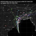
🌀 Cyclone AKVAN – Latest Update-19
✅its 300km away from Gopalpur.The system is moving north-northwestward at around 8 knots, with an estimated intensity of 35 knots. Despite favourable SST (28–29°C), low wind shear (10–15 knots) and strong poleward outflow, its broad and

1
24
2,479
slight eastward turn is also anticipated.
✅🌧️ Heavy to very heavy rainfall, with isolated extremely heavy falls, is likely over Odisha, particularly along and to the right of the projected track district on 19-20th.
✅💨 Strong gusty winds may accompany the system near the
4
405
Debasish Jena retweeted
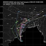
🌀 Cyclone #AKVAN Update | Latest Model Guidance, UPDATE-18
The system is currently located approximately:
📍 400 km south-southeast of Kalingapatnam (Andhra Pradesh).
📍 490 km south of Gopalpur (Odisha).
📍 550 km south of Puri (Odisha).
✅Despite favourable SST (29–30°C) and

🌀 Cyclone #AKVAN Update | Latest Model Guidance, UPDATE-18
The system is currently located approximately:
📍 400 km south-southeast of Kalingapatnam (Andhra Pradesh).
📍 490 km south of Gopalpur (Odisha).
📍 550 km south of Puri (Odisha).
✅Despite favourable SST (29–30°C) and
-Noon.
✅The Myanmar Ridge is expected to influence the system's steering, while interaction with the Subtropical Westerly Jet (STWJ) may increase dynamical forcing and wind shear, contributing to rapid weakening after landfall.
✅🌧️ Rainfall Outlook (19–20 November):
2
5
395
Heavy to very heavy rainfall, with isolated extremely heavy rainfall, is likely over Odisha, particularly along and to the right of the projected track.
#Odisha #Andrapradesh
1
3
323