

Research Scientist, @NASA_Langley, Weather/Climate Science, especially convection, mesoscale processes, and Doppler wind lidar. All views are my own
Hampton, VA
Joined April 2017
- Tweets2.3K
- Following231
- Followers571
- Likes5.6K




Kris Bedka retweeted

✈️We're so excited to show off NASA's B777!
Spend the next 77 seconds with us and take a look inside the features that make this aircraft so special and help advance our airborne science missions.
Kris Bedka retweeted

⚡ 68 lightning flashes PER MINUTE.
That’s what we measured at the peak of Thursday night’s violent DC storm — more than one flash per second. A typical thunderstorm peaks near 10 per minute.
Add 60-70 mph wind gusts and blinding rain, and this was no ordinary storm.
We dug into the data to explain exactly why it became so intense — and whether it was a derecho:
capitalweather.com/how-thurs…

Kris Bedka retweeted

The Great Plains in the USA are one of the most sensitive regions in the world for land surface feedbacks. Essentially, droughts lead to more drought, and floods lead to floods.
The reason is that a lot of our precipitation differences can be tied to the low level moisture content. When we get sufficiently dry that low level moisture drops, storms must rise to a higher level than typical to condense and produce rain. In practice this means some situations that would normally produce rainfall do not.
And then, even if storms do produce rainfall, they see higher evaporation than would normally occur from the larger dew point depressions and hotter near surface temperatures. This is the situation we are in now.
But it gets even worse! Because once the land is sufficiently dried out and moisture has been reduced, the increased heat flux into the atmosphere warms the lower and middle atmosphere more effectively as well. In other words, it somewhat easier to build ridges. So when you have a pattern that supports drought, it feeds back on itself to continue to support drought.
Obviously, this will eventually break, and I think El Nino is going to force that this fall. But this is why I said the general dry pattern will stick around for at least a bit longer in the southern Plains.
Image from (science.org/doi/10.1126/scie…)


Kris Bedka retweeted

This is what happens when you don’t have much storm fuel to get tall storms, but you have a LOT of storm fuel and spin near the cloud base in the lowest 2 miles of the atmosphere.
The cloud’s bottom becomes VERY sucky and efficient at stretching spin (vorticity):


Kris Bedka retweeted

Las U frías (yunque) de muchas de las top supercélulas de granizo gigante en España desde 1980. Peso sacado de la prensa: 200 g ≈ 12 cm, 400 g ≈ 15 cm, 900 ≈ 19 cm. Valores que creo están soportados por la intensidad de los daños y los colosales yunques en U en el satélite.

It is great to see the DCOTSS field campaign overview paper published in BAMS. This campaign was one of the most fun I have worked on in my career. Great leadership, team, and science! journals.ametsoc.org/view/jo…

Kris Bedka retweeted

This week’s East Coast winter storm met the definition of a bomb cyclone, meaning its central pressure dropped at least 24 millibars in 24 hours, signaling rapid intensification. 🌀 Our Tempest network captured intense 3-hour sea-level pressure changes as the system deepened.
Kris Bedka retweeted

A @NASA research aircraft is helping to improve the models that feed storm forecasts 🌨️
The international mission, called NURTURE, will measure moisture, clouds, and ozone as winter storms develop to better understand severe winter weather. go.nasa.gov/45w5uKE

ALT NASA\u2019s G-III aircraft in the hangar at NASA\u2019s Langley Research Center as science and flight crews install remote sensing instruments inside and onto the body of the plane. Credit: NASA/Ryan Hill
Kris Bedka retweeted
NASA’s first Earth-observing satellite was TIROS-1, which monitored cloud cover and weather patterns.
Now, @NASA operates more than 20 satellites that study Earth’s land, water, air, and climate, helping us learn more about this planet we call home. 🌎
Kris Bedka retweeted
Alrighty, ready to see something really cool?
The evolution of Hurricane Melissa's mesovortices at peak strength.
Kris Bedka retweeted

Due to the Hunga eruption in 2022, the stratosphere became intensely hydrated. Now, it is dehydrating much more slowly than expected. The stratosphere may remain abnormally humid for an extended period, prolonging the climate effects of the volcano.
agupubs.onlinelibrary.wiley.…

Kris Bedka retweeted
Clean air matters for everyone. 🌎 With missions like TEMPO, NASA helps track air quality across North America, helping communities plan for a healthier future. #CleanAirDay
Learn more: go.nasa.gov/4m3UQ3d
Kris Bedka retweeted
Today is #NationalAviationDay! ✈️
@NASA airborne missions study Earth from the skies, providing data that helps us better understand our home planet.
These missions also help NASA test new technologies and calibrate and validate measurements taken by satellites in space.

ALT Photograph of NASA’s Dynamic Aviation King Air B200 aircraft head on. A woman wearing sunglasses and a white t-shirt stands on the staircase leading up to the plane, raising her hand to smile and wave at the camera. The plane is sitting on the tarmac and in the background are several buildings. Credit: NASA / Milan Loiacono
Kris Bedka retweeted

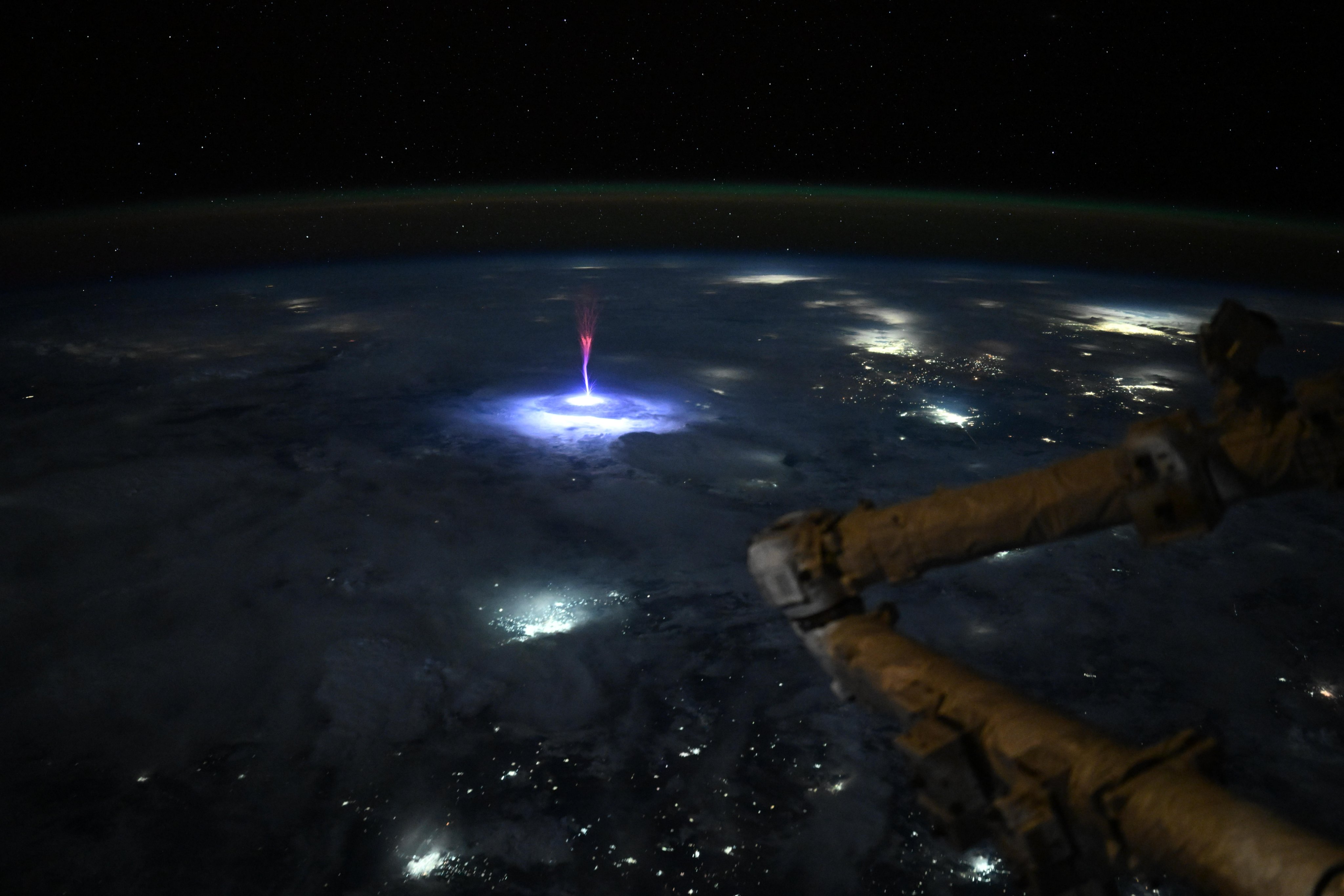
Just. Wow. As we went over Mexico and the U.S. this morning, I caught this sprite.
Sprites are TLEs or Transient Luminous Events, that happen above the clouds and are triggered by intense electrical activity in the thunderstorms below. We have a great view above the clouds, so scientists can use these types of pictures to better understand the formation, characteristics, and relationship of TLEs to thunderstorms.
Kris Bedka retweeted

The AP is tagging along with scientists from Project ICECHIP to chase one of the nation’s costliest but least-appreciated weather dangers: hail. It's rarely deadly, but it causes about $10 billion in damage each year in the U.S. Follow along for the journey.
Kris Bedka retweeted
Hurricanes and severe storms can be disastrous and develop rapidly.
The Aerosol Wind Profiler (AWP) is an instrument NASA is using that can significantly improve our ability to forecast and respond to dangerous weather.
Read more: go.nasa.gov/4cVE4jv