

Official account for the National Weather Service in Omaha/Valley Nebraska. Details: https://teapaw.org/t.co/cc6okHHx0u
- Tweets55.1K
- Following350
- Followers84.5K
- Likes23.7K







ALT The image shows the forecasted max wind gusts (40-50 mph) out of the south this afternoon. What To Know Strong winds develop by mid-morning peaking during the afternoon. Sustained winds of 25-35 mph are expected, joined by gusts of 40-50 mph. Dry weather is forecast ahead of increasing rain chances Sat/Sun. What To Do Exercise caution when driving in high-profile vehicles Make sure outdoor items and decorations are secured.


ALT National Weather Service forecast of high temperatures across the United States for Wednesday, November 25, 2026. Cold conditions dominate the northern and central states, with highs generally in the 30s and 40s across the northern Rockies, Plains, Great Lakes, and Northeast. Highs in the 50s and 60s are forecast across much of the southern United States, with warmer temperatures in the 70s across southern California and parts of the Southeast. Southern Florida is warmest, with highs near 80°F.

ALT National Weather Service forecast of precipitation types across the United States for 7 a.m. EST Wednesday, November 25, 2026. Rain is forecast along the Pacific Coast, with snow across portions of the Cascades, Sierra Nevada, and northern Rockies. Rain is also forecast across much of the Southeast, extending from the lower Mississippi Valley to the Atlantic Coast and Florida. Areas of possible mixed precipitation, freezing precipitation, and snow appear along the northern edge of the precipitation shield, particularly in the Ohio Valley and central Appalachians.

ALT The image on the right shows a hazy blue sky in the background. The foreground has a tree with its leaves turning gold. The left side of the graphic has a three-day graphic showing a cool down and rain chances on Saturday.


ALT Highway camera from Iowa DOT along I80 east at MM 38 near Avoca, IA.

ALT A landscape view of the rolling Nebraska countryside on a bright, sunny autumn day. This image highlights the forecast for Thursday which includes warm and sunny conditions with temperatures in the mid 60s.

ALT National Weather Service 5-day forecast graphic titled "5 Day Forecast Planner," highlighting windy weather today and Friday, rain on Saturday, and cooler temperatures on Sunday. The outlook notes that gusty south winds of 30 to 45 mph will persist today and return on Friday, with rain likely late Friday night through Saturday. Daily highlights include sunny and windy conditions today with highs in the 60s, sunny Thursday with highs in the 60s, Friday partly cloudy and windy with highs in the 60s, rain likely on Saturday with highs in the upper 40s north to mid 60s far south, and a partly cloudy, cooler Sunday with highs in the 40s.


ALT A National Weather Service forecast graphic titled Warm, Dry, and Windy Wednesday, outlining morning and early afternoon wind gusts of 30 to 40+ mph, afternoon highs in the 60s, dry conditions especially over northeast Nebraska, rapid fire spread risks, and recommended actions to secure outdoor items and avoid burning.


ALT A group of people standing indoors in front of NOAA and National Weather Service logos. One individual in the center holds a sign that reads, "StormReady We Are StormReady Be Prepared!" The group is smiling and dressed in business casual attire.

ALT Two individuals hold a "StormReady" sign in front of a National Weather Service logo. The sign reads "We Are StormReady. Be Prepared!" They are dressed in business casual attire, and both are smiling.

ALT A person standing at a podium with a UNMC logo, speaking to an audience.

ALT A group of people sitting and smiling at tables in a well-lit interior space with ornate architectural details.

ALT National Weather Service Omaha/Valley, NE forecast graphic titled "Mild Weather Continues: Temps Fall Sunday and Remain Cool Next Week." A bar chart displays Omaha forecast temperatures from Wednesday through Sunday: Wednesday low 46°, high 64°; Thursday low 41°, high 64°; Friday low 50° (record warm low 51°), high 68°; Saturday low 52° (record warm low 47°), high 56°; Sunday low 30°, high 45°. Accompanying notes state that normal mid-November highs are near 50°, near-record warm mornings will dip only to near 50°, and a Saturday cold front will bring a 60% chance of rain before temperatures drop for Sunday.





ALT Dark, moody storm clouds on the left transition to a lighter gray sky on the right. Left-aligned white and cream text reads: "Weeping Water, NE. On This Date, November 17, 2003. A weak F0 tornado briefly touched down in an open field southwest of town causing no apparent damage." The National Weather Service Omaha logo is in the bottom right corner.


ALT Family watches TV as Emergency Alert message scrolls on screen.
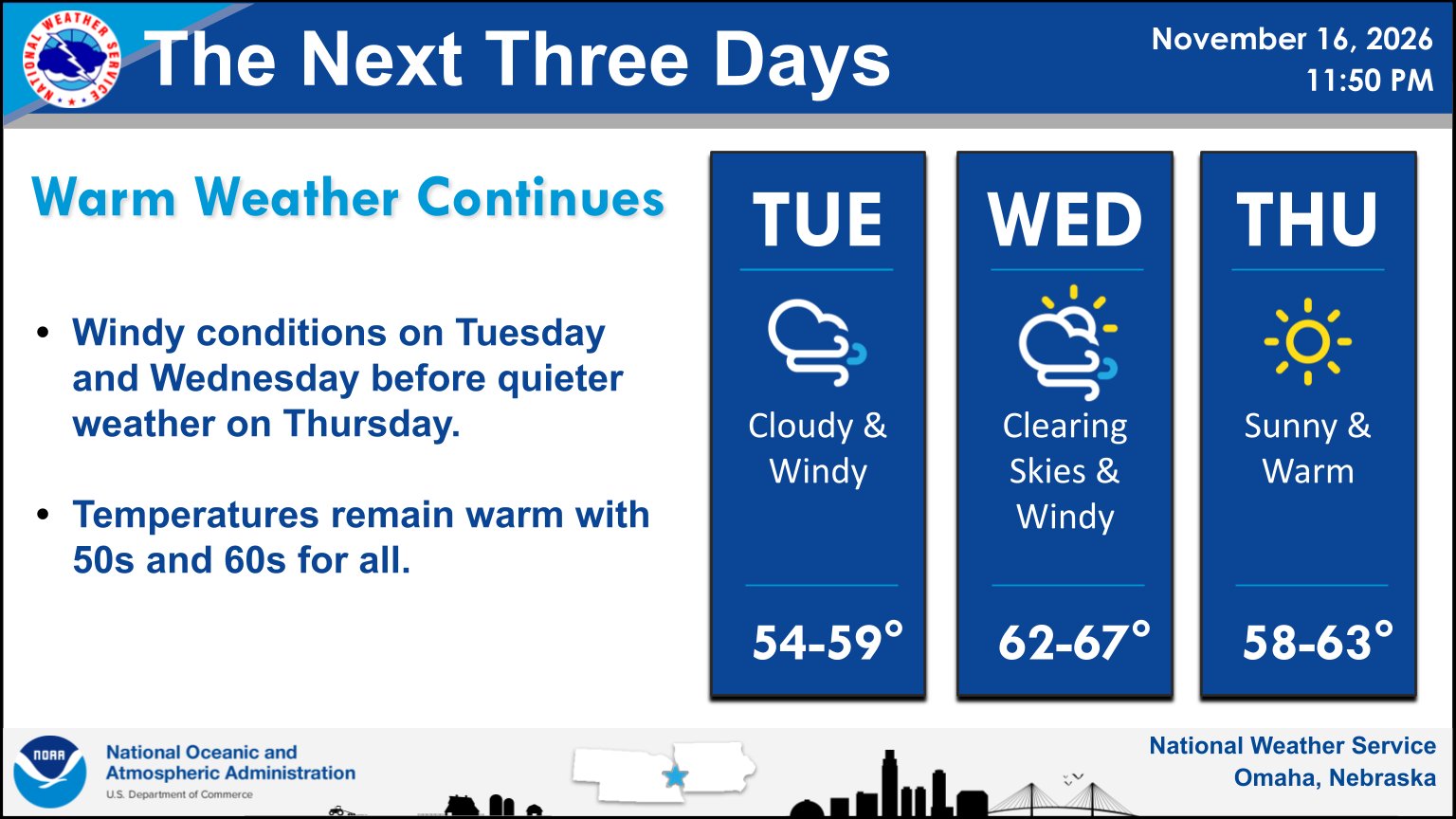
ALT A weather forecast graphic titled The Next Three Days, detailing the forecast from Tuesday through Thursday. Tuesday features cloudy and windy conditions with highs in the mid-to-upper 50s. Wednesday brings clearing skies and windy weather with highs in the mid-60s. Thursday turns sunny and warm with highs in the upper 50s to low 60s.

ALT NWS Omaha weather graphic from Nov. 16, 2026. Lincoln Forecast: Tue decreasing clouds/breezy, high 59°, low 45°; Wed mostly sunny/breezy, high 63°, low 42°; Thu sunny, high 62°, low 50°; Fri mostly cloudy/breezy, high 66°. Lincoln Almanac (2026 vs. normal at Lincoln Municipal Airport): Precip. 37.68" (+10.08"), Avg max temp 71.2° (+3.9°), Avg min temp 46.7° (+3.2°).

ALT National Weather Service Omaha graphic for November 16, 2026, titled 'MORNING LOWS'. The background features a harvested field at sunrise. The forecasted low temperatures are: Norfolk 35°, Sioux City 28°, Columbus 32°, Omaha 32°, Lincoln 30°, Clarinda 23°, Fairbury 29°, and Falls City 28°.

ALT A National Weather Service forecast graphic titled "September in November?" displaying a high temperature line chart comparing current forecast high temperatures to normal temperatures for Omaha, Lincoln, Norfolk, and Red Oak, alongside text highlighting dry, warm, and breezy conditions this week with high temperatures in the 50s and 60s.