
rapidlasso - fast tools to catch reality. Creators of LAStools and LASzip. Chasing LiDAR remote sensing beyond the cutting edge.
Germany
Joined April 2010
- Tweets3.5K
- Following302
- Followers3K
- Likes69.8K





martin isenburg retweeted

23GB of #lidar down to 4GB. LASzip Bests .zip and .zipx for compression. Thanks @rapidlasso @LAStools #OpenData laszip.org/

martin isenburg retweeted

Wow! British Columbia finally releases their tax-payer funded #LiDAR as #opendata, eh? See @rapidlasso taking new #LidarBC portal for quick test run: Smooth download of Computer Science and Forestry building at @UBC Vancouver. #gischat #phdchat #BCWildfire rapidlasso.com/2021/07/02/ne…
martin isenburg retweeted
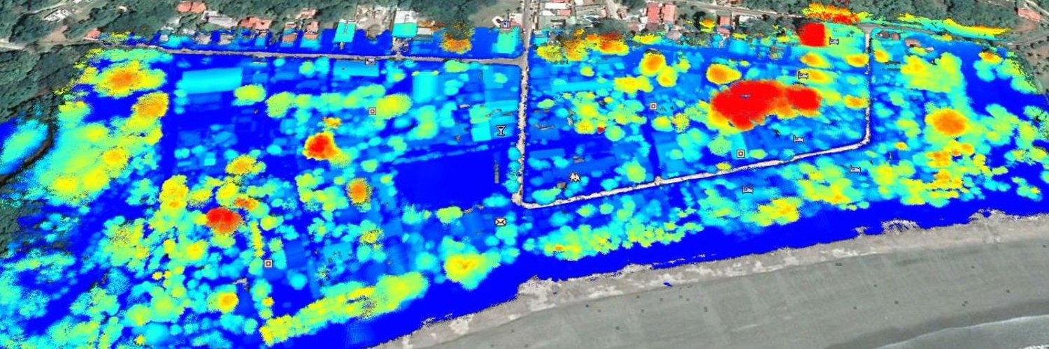
For some of @rapidlasso's projects, the StripAlign software by @bayesmap has significantly reduced misalignment between #LiDAR flightlines. Can it improve our drone flight with @LiDARLatam that carried #Livox Mid-40 by @LivoxTech on M300 RTK by @DJIGlobal? samaramangroves.wordpress.co…


martin isenburg retweeted

Last day of our #lidar work at Santa Rosa NP Supersite by our partner @LiDARLatam Now the fun starts with advanced data processing to discover new changes using airborne and drone lidar data @ACGuanacaste @LAStools #bosqueseco #CostaRica


martin isenburg retweeted
Our #lidar work at Santa Rosa NP supersite continues. After collecting 1500 ha of data via airplane we continue with high resolution Lidar at our long-term monitoring plots @ACGuanacaste @LiDARLatam @NSERC_CRSNG @LAStools #bosqueseco #CostaRica


martin isenburg retweeted
The flight trajectory of the survey helicopter that was carrying an IGI #Litemapper 6800 with @RIEGL Q680 laser scanner and @Hasselblad H5D-50 mid-size camera to map Samara in full color 3D from above in February 2021. #LiDAR @MangrovesNow @marine_conserve samaramangroves.wordpress.co…

martin isenburg retweeted
Last weekend the @LAStools guy got the toughest environmental lawyer of Costa Rica on his team to return the destroyed mangroves in Samara from inventors into the Patrimony of the People using the fundamental Law of the irreducibility of wetlands. #LiDAR
facebook.com/groups/coalicio…

martin isenburg retweeted

Evon Silvia of the @ASPRSorg LAS Working Group describes how the @github Actions work to build the specification PDF in this @lidarmag article lidarmag.com/2021/05/22/las-…

Last weekend the @LAStools guy got the toughest environmental lawyer of Costa Rica on his team to return the destroyed mangroves in Samara from inventors into the Patrimony of the People using the fundamental Law of the irreducibility of wetlands. #LiDAR
facebook.com/groups/coalicio…
martin isenburg retweeted
Who didn't want to beat up the @LAStools guy at one point in their life? We @rapidlasso understand you. We could be billionaires if it wasn't for antiques of our crazy boss' obsession with #laserchickens. ☢️💚🐥 Finally he got slapped. We filmed it: instagram.com/tv/CO-dgg3nwh3… #LiDAR
martin isenburg retweeted
Another reason why @rapidlasso lobbied hard to add "extra bytes" to #LAS standard of @ASPRSorg. Store epoch of coordinates for dynamic WGS84 datum EPSG 4326 or 3857 as a DOCUMENTED additional attribute and join LAS Working Group to standardize it. #LiDAR xitter.cf/nyalldawson/status/139…

Who didn't want to beat up the @LAStools guy at one point in their life? We @rapidlasso understand you. We could be billionaires if it wasn't for antiques of our crazy boss' obsession with #laserchickens. ☢️💚🐥 Finally he got slapped. We filmed it: instagram.com/tv/CO-dgg3nwh3… #LiDAR
martin isenburg retweeted
Geospatial hero this week is Dr. Michael Dennis from @NOAA's NGS. Not only did he beat me in appearing on @TheDailyShow, he also initiated the beginning of the end for the two different definitions of "feet" used by surveyors in the US. youtu.be/b_NL8NHFlIU #LiDAR #GisChat
martin isenburg retweeted
It's neither my #laserchickens' birthday nor Christmas, but @GeoPlexNews gives the #Linux kernel of the #LiDAR community a little #pointcloud present. #gischat #ArcGIS xitter.cf/geoplexnews/status/138…

Liberate proprietary zLAS files on Linux systems with this Docker Image: github.com/GeoplexGIS/docker…
CC @LAStools

martin isenburg retweeted

Much anticipated #GEDI release 2 is here! Easier search and subset, improved waveform processing for L2A and L2B metrics, improved geolocation. #OpenData #lidar

The Global Ecosystem Dynamics Investigation (#GEDI) Version 2 data products are available at #LPDAAC. Improvements such as increased geolocation accuracy and updated metadata make finding, downloading + working with the data easier. bit.ly/2REiKcO #LIDAR @GEDI_Knights

martin isenburg retweeted
Proceeds from license sales by @rapidlasso are now used for environmental projects in Costa Rica: scanning nature surrounding our tropical office, detecting and quantifying environmental crimes and hiring lawyers to bring perpetrators to justice ... ☢💚🐥
samaramojones.wordpress.com/…

martin isenburg retweeted
New #LASliberator by @rapidlasso sets free imprisoned #LiDAR point type 6 to 10 of LAS 1.4 from @Esri's proprietary lock-in format to #LAS or #LAZ. rapidlasso.com/LAStools #EsriUC #gis #INTERGEO #INTERGEO18 #ForestSAT #ILMF19 #geobiz #uavexpo #uav #geoweek #INTERGEO2018 #opendata

martin isenburg retweeted
Incredible crimes against last #mangroves in Samara. How to stop the killing, @ACGuanacaste? #WorldWaterDay Increíbles crímenes contra los últimos #manglares en Samara. ¿Cómo detener la matanza, @TropiDry? #DiaMundialDelAgua @VozdeGuanacaste @TheCRNews samaramangroves.wordpress.co…

Incredible crimes against last #mangroves in Samara. How to stop the killing, @ACGuanacaste? #WorldWaterDay Increíbles crímenes contra los últimos #manglares en Samara. ¿Cómo detener la matanza, @TropiDry? #DiaMundialDelAgua @VozdeGuanacaste @TheCRNews samaramangroves.wordpress.co…
martin isenburg retweeted
After @LiDARLatam flew @DJIGlobal M300 drone carrying #LiDAR system by @GeosunNav with #Livox Mid40 #laserscanner from @LivoxTech above destroyed @TropiDry mangrove in @ACGuanacaste, we fixed flight line misalignments with software and help from @BayesMap rapidlasso.com/2021/03/04/st…