

Views are personal.. Senior Hydromodeler, Integrated Flood Mgt Centre, TN State Disaster Mgt Agency. Ex-Program Manager @ WRI, India. PhD Scholar @ IIT MADRAS.
Chennai, India
Joined July 2009
- Tweets2.7K
- Following150
- Followers6.1K
- Likes13.1K

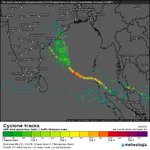


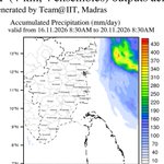


Cyclone #Akvan | 19 Nov | Morning Update
Akvan continues to move northwards over the westcentral Bay of Bengal. The system is experiencing increasing structural asymmetry, with intense convection displaced towards its northern sector.
Landfall: IMD maintains its forecast between Narsapur and Puri by noon on 20 Nov, with model guidance increasingly favouring the vicinity of Gopalpur in South Odisha.
Will Akvan weaken before landfall?
The possibility is increasing. JTWC has further reduced its intensity estimate to 35 knots (~65 kmph), while IMD's latest advisory acknowledges that ECMWF suggests weakening below cyclonic storm intensity before landfall.
Despite favourable ocean temperatures, increasing vertical wind shear and cold, dry air intrusion from the Indian landmass are likely to limit its intensification and induce weakening.
Rainfall impact: The latest ECMWF and GFS runs indicate significant rainfall over North coastal Andhra Pradesh, Odisha and Gangetic West Bengal during 19–20 Nov. Locally very heavy to extremely heavy rainfall remains a concern, irrespective of the weakening cyclone intensity.
Tamil Nadu: Akvan's rainfall influence has become negligible over most parts of TN, including #Chennai. Rough seas and gusty coastal conditions remain the primary concerns.
#BayOfBengal #AndhraPradesh #Odisha #TNRains


Cyclone #Akvan | 18 Nov | Evening Update
Akvan has picked up pace after its prolonged near-stationary phase, moving north-northwestwards at 8 kmph, about 560 km east of #Chennai.
IMD, JTWC, ECMWF and GEFS are now in better agreement on the broader track towards North Andhra Pradesh and South Odisha, with a considerable reduction in the projected intensity.
Landfall: Between Narsapur and Puri by noon on 20 Nov, as a Severe Cyclonic Storm with winds of 90–100 kmph, gusting to 110 kmph, as per IMD. JTWC suggests a weaker system, with increasing vertical wind shear likely to induce further weakening before landfall.
Primary impact regions: North coastal Andhra Pradesh, Yanam and South Odisha, with heavy to extremely heavy rainfall, strong winds and a possible storm surge of 0.5–1.0 m during 19–20 Nov. A reduction in cyclone intensity does not necessarily translate into a proportionate reduction in rainfall impact.
Tamil Nadu: A largely dry spell is expected during 19–21 Nov, including Chennai, as per RMC Chennai's latest bulletin. However, rough to very rough seas and coastal winds gusting to 70 kmph remain a concern along North TN during 19–20 Nov. Rainfall activity is expected to resume from 22 Nov.
Why has Akvan been a challenging system to forecast?
Akvan was caught between two competing ridges, the Indo-Arabian ridge to its west and the Indo-Pacific ridge to its east, resulting in weak net steering currents and prolonged near-stationary movement.
Differences in how models represented the strength and evolution of these ridges, coupled with variations in cyclone intensity and vertical structure, contributed to the persistent ensemble spread.
While IMD consistently favoured an Andhra Pradesh-bound track, its projected landfall corridor evolved from Nellore–Tuni to Nellore–Visakhapatnam and now Narsapur–Puri. The projected landfall winds have reduced from 120–130 kmph to 90–100 kmph.
With the eastern ridge becoming the dominant steering influence, a more northward trajectory is emerging. Even at a two-day lead time, JTWC reported a cross-track spread of around 407 km among model guidance.
Akvan is a particularly interesting case of cyclone predictability under competing atmospheric steering influences. While the broader direction was reasonably established earlier, the uncertainties in track and intensity have translated into substantial changes in regional impact forecasts.
#BayOfBengal #AndhraPradesh #Odisha #TNRains

Cyclone #Akvan | 18 Nov | Morning Update
Akvan continues its slow northward movement at 3 kmph, located about 590 km east of #Chennai as of 2:30 AM. Intensification has been slower than initially anticipated.
IMD maintains its landfall forecast between Nellore and Visakhapatnam around noon on 20 Nov as a Very Severe Cyclonic Storm (120–130 kmph, gusting to 145 kmph). However, JTWC and the latest ECMWF and GEFS ensembles favour a weaker system, with a greater inclination towards central and northern coastal Andhra Pradesh.
What to expect:
• Andhra Pradesh: Primary impact region, with heavy to extremely heavy rainfall, strong winds and a possible storm surge of 0.4–1.2 m during landfall - mostly expected around Nov 20.
• Odisha: Heavy to very heavy rainfall during 19–21 Nov. Rainfall also extends into Telangana and Chhattisgarh subsequently.
• Tamil Nadu: Rainfall prospects have reduced further in the latest model runs. Limited light to moderate spells, with isolated spells possible over North Chennai and coastal Tiruvallur on 19 Nov. No widespread heavy rainfall signal at present.
Rough to very rough seas and coastal winds gusting to 70 kmph remain a concern along North TN on 19–20 Nov.
The broader track is becoming clearer, but considerable differences persist in the projected intensity during landfall.
#BayOfBengal #TNRains #NEM2026


Cyclone #Akvan | 17 Nov | Evening Update
#Akvan continues its slow northward movement at 3 kmph, with considerable fluctuations in its convective organisation throughout the day.
IMD has widened the landfall corridor to Nellore–Visakhapatnam, with the crossing expected around noon on 20 Nov as a Very Severe Cyclonic Storm, with winds of 120–130 kmph, gusting to 145 kmph.
Rainfall outlook:
• 18–19 Nov: Both ECMWF and GFS retain the core rainfall activity largely offshore, with rainfall extending towards coastal Andhra Pradesh and Odisha.
• 19–20 Nov: Rainfall activity shifts closer to coastal Andhra Pradesh. GFS places the heavy rainfall core farther south than ECMWF. Odisha also sees significant rainfall activity.
• Tamil Nadu: Rainfall prospects have reduced considerably. Light to moderate spells are expected over Chennai and adjoining coastal districts, with relatively heavier spells possible over North #Chennai and coastal #Tiruvallur, particularly towards Pulicat.
Our preliminary 4 km WRF simulations also indicate a similar spatial pattern, with rainfall largely subdued over southern Chennai and the upstream reservoir catchments.
Wind remains a concern, with IMD indicating 60–80 kmph winds, gusting to 90 kmph, along and off the North TN coast on 19 Nov. Much stronger winds are expected along the Andhra coast.
Coastal Andhra Pradesh remains the primary impact region. As of now, no widespread heavy rainfall threat is evident for Chennai. Close monitoring is necessary.
#BayOfBengal #TNRains #NEM2026


Cyclone #Akvan | 17 Nov | Morning Update
Akvan has remained nearly stationary overnight, with its movement slowing to just 3 kmph. Meanwhile, satellite imagery this morning shows a substantial expansion of deep convection.
Interestingly, IMD and JTWC differ in their assessment of the system's current position, movement and expected intensification. However, both anticipate a subsequent northwestward movement towards coastal Andhra Pradesh.
IMD maintains its forecast of landfall between Nellore and Tuni around noon on 20 Nov as a Very Severe Cyclonic Storm.
For #Chennai and North TN, the latest GFS and ECMWF runs indicate increased rainfall prospects. The system's subsequent movement and proximity to the coast will determine the extent of rainfall and wind impacts.
The next 12–24 hours will be important in understanding the system's evolution, particularly given its slow movement.
#BayOfBengal #TNRains #NEM2026


Cyclone #Akvan | 16 Nov | Evening Update
The deep depression intensified into Cyclonic Storm Akvan at 5:30 PM IST today. It is currently located about 610 km east of #Chennai, moving north-northwestwards at 10 kmph.
As per IMD, Akvan is likely to intensify into a Severe Cyclonic Storm by 17 Nov evening and a Very Severe Cyclonic Storm by 19 Nov morning, crossing the Andhra Pradesh and Yanam coasts between Nellore and Tuni around noon on 20 Nov, with winds of 120–130 kmph, gusting to 145 kmph.
ECMWF and GEFS ensemble guidance increasingly favours a northwestward approach towards coastal Andhra Pradesh. While uncertainty persists in the exact landfall location, a broader agreement on the likely track is emerging.
For Tamil Nadu, particularly #Chennai and adjoining northern coastal districts, rainfall prospects remain significant during 18–20 Nov, with isolated heavy to very heavy spells possible.
Strong winds and deteriorating sea conditions are equally important concerns along the North TN and Andhra coasts. Fishermen should strictly adhere to IMD's marine advisories.
18–20 Nov remains the critical period for North TN and coastal Andhra Pradesh. While forecasts are gradually converging towards a broader landfall corridor, further shifts in the track could significantly alter the spatial extent and magnitude of rainfall and wind impacts.
#BayOfBengal #TNRains #NEM2026 #Akvan


WRF ensemble members (based of GFS) not picking much rains from this cyclone for #Chennai and NorthTN...let's see if further runs improve..

Bay of Bengal Cyclone | 16 Nov - Early Morning Update
The depression over the Bay of Bengal is expected to intensify into a cyclonic storm today, a severe cyclonic storm by 17 Nov and a very severe cyclonic storm by 18 Nov, as per IMD.
A significant westward shift in the ECMWF and GEFS ensemble tracks is evident compared to earlier forecasts, increasing the rainfall prospects for North Tamil Nadu, including #Chennai.
While the primary cyclone threat remains towards Andhra Pradesh and adjoining south Odisha, Models started indicating isolated heavy to very heavy rainfall over North Tamil Nadu, Puducherry and Karaikal during 18–19 Nov.
The models continue to differ considerably in the extent and magnitude of rainfall over coastal TN. ECMWF and GEM indicate substantial rainfall potential, while GFS and AI-based models show varying degrees of coastal influence.
18–20 Nov remains the key period to watch, particularly for North TN #Chennai and coastal Andhra Pradesh. Further changes in the track could significantly alter the rainfall distribution. Close monitoring is essential, as #NorthTN #Chennai is now well within the potential rainfall influence region of the system.
Wind and sea conditions are also significant concerns. Squally winds of 40–50 kmph, gusting to 60 kmph, and rough to very rough seas are expected along and off North TN and Puducherry coasts till 18 Nov. Conditions along the Andhra coast could become considerably more severe, with winds reaching 120–130 kmph, gusting to 145 kmph, by 19 Nov evening.
#BayOfBengal #TNRains #NEM2026


Bay of Bengal Cyclone Update | 14 Nov
The system has intensified into a well-marked low-pressure area over the southeast Bay. IMD expects it to become a depression by 15 Nov morning, a cyclonic storm by 16 Nov evening and a severe cyclonic storm by 18 Nov morning.
While confidence in intensification has increased, uncertainty in the subsequent track persists. The latest ECMWF ensemble shows some members shifting towards the north Tamil Nadu–south Andhra coast, while other scenarios favour a more northward movement.
Rainfall outlook: Both ECMWF and GFS currently indicate that the core rainfall activity will largely remain over the sea during 16–18 Nov. Coastal Tamil Nadu, including Chennai, may experience intermittent spells, but no widespread heavy rainfall signal is evident at present.
The rainfall threat increases over coastal Andhra Pradesh, Odisha and West Bengal during 18–20 Nov.
A closer approach towards TN cannot yet be ruled out, particularly given the evolving ensemble spread.
#BayOfBengal #TNRains #NEM2026


Another system in the Bay of Bengal, but why so much uncertainty? 🌀
A low-pressure area formed over the southeast Bay of Bengal this morning (13 Nov) and is likely to intensify into a depression around 15 Nov.
While ECMWF and GEFS ensembles broadly indicate an initial north-northwestward movement, subsequent tracks show considerable divergence, ranging from an approach towards the Tamil Nadu–Andhra coast to a northward recurvature.
Why? The system is still evolving. Small differences in its initial position, rate of intensification and interaction with atmospheric steering winds can lead to significantly different tracks.
The key uncertainty is not just where the system will move, but how much it will intensify and how that influences its subsequent movement.
For Tamil Nadu, including Chennai, it is too early to establish the rainfall impact. The next 48–72 hours should provide better clarity.
The track uncertainty is expected to reduce as the system becomes better organised over the next 2–3 days.
#BayOfBengal #NEM2026 #TNRains


Tamil Nadu Rainfall Update | 7 Nov
Rain activity is largely concentrated over southern TN and adjoining coastal areas, with isolated thunderstorms across parts of the south and Western Ghats. Parts of south #Chennai also received showers this morning, with activity reducing considerably thereafter.
During 8–9 Nov, southern districts, particularly #Ramanathapuram, #Thoothukudi, #Tirunelveli, #Tenkasi and #Kanniyakumari, have better chances of rainfall. Parts of delta districts #Trichy #Thanjavur can also expect scattered rains during noon-evening hours. #Chennai and most northern districts may see relatively subdued activity, with chances of isolated moderate spells.


🌀 #Murasu Weakens, but Flooding Concerns Remain | 4 Nov Morning
Cyclone #Murasu has weakened into a Depression over east Telangana and adjoining coastal Andhra Pradesh. Further weakening into a well-marked low-pressure area is expected today.
🌧️ Andhra Pradesh: Though the cyclone has weakened, its associated convection remains active. Further moderate to heavy spells are possible over parts of central and coastal AP, particularly around #Krishna, #NTR and adjoining districts.
Flooding remains the bigger concern now. Murasu's unusually slow movement near and after landfall has prolonged rainfall over several catchments, increasing cumulative rainfall and the risk of flooding and waterlogging. Even moderate additional rainfall could worsen conditions in already saturated areas.
🌀 What next? Northward movement has continued so far. As the circulation weakens and becomes shallower, some models indicate a possible southwestward shift of its remnants just to cause some activity in interiors of #Karnataka. However, track confidence is only moderate, and further weakening is more certain, so lesser impact in any case.
🌧️ Tamil Nadu: Rainfall prospects are improving for interior and Western Ghats districts over 4–7 November.
Light to moderate rainfall is possible across several parts of TN, with locally #moderate to #heavy spells particularly along the #WesternGhats, including #Nilgiris, #Coimbatore, #Tenkasi #Coutrallam, #Theni and #Dindigul, and pockets of the western and central interiors #Trichy #Thanjavur .
For #Chennai and the adjoining northern coastal belt, occasional light to moderate showers remain possible, but prospects of widespread rains are very low.
#CycloneMurasu #AndhraPradesh #TamilNadu


🌀 Cyclone #Murasu: A flood causing system!
Murasu's slow movement near landfall extended its rainfall influence well beyond the coastal crossing, with heavy accumulations continuing across parts of Andhra Pradesh. Unlike #Arnab, which brought intense rainfall over a shorter period, Murasu's impact was marked by sustained rainfall extending farther inland.


1
2
308
NEM UPDATE || 4 Nov 2026:
🌧️ Tamil Nadu: Rainfall prospects are improving for interior and Western Ghats districts over 4–7 November.
Light to moderate rainfall is possible across several parts of TN, with locally #moderate to #heavy spells particularly along the #WesternGhats, including #Nilgiris, #Coimbatore, #Tenkasi #Coutrallam, #Theni and #Dindigul, and pockets of the western and central interiors #Trichy #Thanjavur .
For #Chennai and the adjoining northern coastal belt, occasional light to moderate showers remain possible, but prospects of widespread rains are very low.


3
523
🌀 Cyclone Murasu | 3 Nov Evening: The changing track!
After a prolonged landfall near Ongole, #Murasu has weakened into a Cyclonic Storm, with winds of 80–90 kmph, gusting to 100 kmph. Its movement remains unusually slow, around 7 kmph.
🌧️ Two cyclones, contrasting rainfall footprints:
#Arnab brought its highest accumulations over Vizianagaram, Visakhapatnam and Anakapalli, while #Murasu concentrated its heaviest rainfall over #Palnadu, #Bapatla, #Prakasam and #Guntur. #Krishna, #Bapatla, #Guntur and #WestGodavari experienced substantial rainfall during both events.
Rainfall continued beyond the 2 PM cutoff of the attached maps, particularly around the Bapatla–Guntur–Palnadu belt.
🌀 What next?
Murasu is more likely to continue its slow north-northwestward movement tonight while weakening into a Deep Depression. As the circulation becomes shallower, a westward turn is possible on 4 November.
The next 6–12 hours should provide better clarity on this possible change in direction. Rainfall may continue over parts of Andhra Pradesh and adjoining interiors before gradually reducing.
Murasu's slow movement and changing steering conditions have made its final phase particularly interesting to follow.
#AndhraPradesh #CycloneMurasu


🌧️🌬️ Cyclones Arnab & Murasu | A Week of Relentless Rain and Strong Winds across Andhra Pradesh:
An exceptionally rare sequence, with Cyclones #Arnab and #Murasu striking the Andhra coast within a week, bringing intense rainfall and destructive winds.
*How much rain in just a week?
AP DES station observations show a combined accumulation of 429 mm at Hamsaladevi in Krishna district across the two cyclone periods. A station in Kakinada district recorded 306 mm. (Indicative only, th accumulation is only until 2pm of 3 Nov. Considerable rains happened after that as well)
🌧️ Arnab (27–28 Oct): Highest station rainfall reached 355 mm in Vizianagaram, 346 mm in Visakhapatnam, 331 mm in Anakapalli, 320 mm in Srikakulam and 280 mm in Kakinada.
🌧️ Murasu (2–3 Nov, until 2 PM): Palnadu recorded 285 mm, Bapatla 267 mm, Prakasam 221 mm, Guntur 205 mm, Kakinada 80 mm. Further intense spells were reported after the observation cutoff.
🌬️ And the winds? Arnab was the stronger cyclone, with estimated landfall winds of 125–135 kmph, gusting to 150 kmph, against Murasu's 100–110 kmph, gusting to 120 kmph.
During Murasu, AP DES recorded station wind maxima of 73 kmph in Prakasam, 67 kmph in Eluru and 65 kmph in Prakasam.
Arnab brought greater wind intensity and higher peak station rainfall. Murasu's slow movement prolonged heavy rainfall and #flooding concerns.
For several communities, it was barely a week between two major cyclone impacts, with little opportunity to recover from the first.
Source: AP DES AWS/ARG observations. Combined totals refer to matched stations across two different observation periods, not continuous seven-day rainfall. Station maxima are not district averages.
#AndhraPradesh #CycloneArnab #CycloneMurasu


4
563
🌀 Cyclone Murasu | 3 Nov Morning: A prolonged landfall along the Andhra coast!*
Severe Cyclonic Storm #Murasu has maintained an impressive structure right up to landfall near #Ongole. At 4:30 AM, its centre was just 20 km east-southeast of Ongole, with winds of 100–110 kmph, gusting to 120 kmph. The eyewall has already begun moving inland.
What stands out is how the cyclone evolved during its final approach. Murasu strengthened considerably over the past two days, developing a well-organised eyewall. Even as it approached the coast, it retained its intensity while its forward movement slowed sharply, from around 25 kmph yesterday morning to just 8 kmph over the past six hours.
This combination has made the landfall more prolonged, extending the period of strong winds (Maximum sustained winds:100–110 kmph, Peak gusts: Up to 120 kmph) and intense rainbands along the coast.
🌧️ Andhra Pradesh: #Prakasam, #Bapatla and adjoining coastal districts remain the main impact zone, with heavy rainfall also threatening #Guntur, #Krishna, #Nellore and neighbouring areas. Kothapatnam in Prakasam has already recorded 164 mm rainfall between yesterday morning and 4 AM today.
🌊 Damaging winds are expected to continue through the morning, with storm surge of 1–1.5 metres posing an inundation risk along vulnerable coastal stretches.
What next? Murasu is expected to weaken as it moves inland, first into a Cyclonic Storm and subsequently a Deep Depression. However, rainfall and flooding risks may persist even after winds begin to subside.
For #Chennai and north Tamil Nadu, the core influence has shifted northwards, with the more serious impacts now concentrated over Andhra Pradesh. Interiors of TN can get scattered moderate rains.
The next 6-12 hours remain critical for heavy rains along the Andhra coast, even as the cyclone begins to lose strength.
#CycloneMurasu #AndhraPradesh #BayOfBengal


Severe Cyclonic Storm Murasu | 2 Nov Evening Update
#Murasu has slowed considerably as it approaches the Andhra Pradesh coast. Its movement reduced from around 22 kmph this morning to 12 kmph by 5:30 PM, tracking north-northwestwards, nearly parallel to the coast.
At 5:30 PM, the centre was about 110 km southeast of Ongole. Landfall is still expected south of Ongole between 11:30 PM tonight and 4 AM tomorrow. An earlier landfall is still possible though.
Andhra Pradesh: #Nellore, #Prakasam, #Bapatla and adjoining coastal districts remain the main concern. Slow movement could prolong strong winds and intense rainfall along the coast. Storm surge is another significant threat, particularly around Prakasam, Bapatla and Krishna.
#Chennai & North TN: The main rainfall phase appears to have passed. Widespread heavy rainfall appears less likely in the immediate outlook. Isolated moderate rain and thunderstorms remain possible, particularly across Chennai, Tiruvallur, Kancheepuram and Chengalpattu.
Rest of TN: Scattered showers are possible over western and interior districts, with locally heavier spells along the ghats.
#CycloneMurasu #AndhraPradesh


🌀 Cyclone Murasu | 2 November, Morning Update
Severe Cyclonic Storm #Murasu continues moving towards the Andhra Pradesh coast. At 5:30 AM, it was centred about 200 km east-northeast of #Chennai, moving west-northwestwards at 25 kmph.
Landfall: Expected between #Nellore and #Narsapur, close to #Ongole, between 11:30 PM tonight and 4 AM tomorrow, with winds of 100–110 kmph, gusting to 120 kmph.
🌧️ Chennai & Tiruvallur
Moderate to heavy rainfall occurred across parts of #Chennai city last night, followed by a noticeable reduction in rainfall activity this morning.
However, this lull may be temporary. Latest high-resolution WRF guidance suggests another round of rainfall later today, with the stronger signal during the evening and night, particularly between 6 PM and midnight.
Other global models differ considerably on the rainfall intensity and timing. Intermittent moderate rainfall with locally heavy spells remains possible, particularly over northern Chennai, #Tiruvallur and adjoining coastal areas.
🌧️ Andhra Pradesh
The main cyclone impact zone remains the south and central Andhra Pradesh coast, particularly #Nellore, #Prakasam, #Bapatla, #Guntur and #Krishna, along with adjoining districts.
Very heavy to isolated extremely heavy rainfall is possible during 2–3 November. Damaging winds are expected near the landfall region, with heavy rainfall potentially extending inland.
🌊 Winds & Sea Conditions
Strong, gusty winds are expected along the north Tamil Nadu coast, potentially reaching 60–70 kmph, gusting to 80 kmph during the peak period.
The Andhra Pradesh coast faces stronger winds near landfall, along with a possible storm surge of 1–1.5 metres in vulnerable coastal stretches. Sea conditions remain dangerous for marine activities.
The primary cyclone threat continues to be over coastal Andhra Pradesh.
#ChennaiRains #TamilNadu #AndhraPradesh


