

weatherTAP has the the fastest, most reliable weather on the web! NASCAR, the Pentagon, Pro Golf & TVA choose us as their primary weather provider!
United States
Joined April 2009
- Tweets7.4K
- Following212
- Followers5.3K
- Likes4.5K
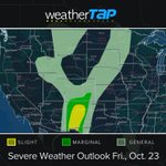





Slight Risk fo severe storms for parts of NM, S CO & far West TX, alongside a Slight Risk for Excessive Rainfall. Main threats are large hail (primary), damaging wind gusts, heavy rainfall (1–1.5"/hr) & an isolated tornado.
#NMwx #COwx #TXwx #WeatherTAP #SevereWeather #FlashFlood


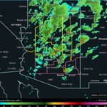
WATCH UPDATE: Tornado Watch (yellow) has been issued for parts of northern/central AZ (including Flagstaff, Prescott & Payson) until 8:00 PM CDT (6:00 PM MST). Severe Thunderstorm Watch (pink) is also active across south-central AZ, including the Phoenix metro area. #AZwx

SEVERE WEATHER OUTLOOK: An Enhanced Risk (Level 3/5) is in effect today across parts of AZ.
Expect multiple rounds of severe storms capable of producing very large hail (2”+), damaging wind gusts & a few isolated tornadoes. 1/2
#azwx


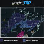
An early taste of winter has arrived! Highs will drop 15–25° below normal from the Southern Plains through the Ohio Valley, Mid-Atlantic & Northeast. Widespread Frost Advisories & Freeze Warnings are in effect through Sunday. Protect sensitive plants!


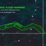
Isaias packed 117 mph gusts in the Florida Panhandle and dumped nearly 13" of rain across the Southeast. Flash Flood and Flood Warnings remain active across the southern Appalachians tonight. Stay safe and weather-aware. #Isaias

FLASH FLOODING UNDERWAY: RadarLab X MRMS composite reflectivity shows tropical moisture from Rachel’s remnants slamming the Desert SW.
Flash Flood Warnings active (CONSIDERABLE damage tag)
SW Mohave Co, AZ: 0.75–2.00" reported
Central Mohave Co., AZ: 0.75–1.25" down (1/2)
Riverside/Imperial Co., CA & La Paz Co., AZ: Up to 1.75" fallen (Blythe, I-10 mm 136–145, CA-78, CA-95) with more rain moving through.
Never drive through flooded roads—Turn Around, Don't Drown! #AZwx #CAwx #FlashFlood (2/2)


TROPICAL STORM #RACHEL is moving NE at 22 mph with 60 mph sustained winds.
• Tropical Storm Warning active for Baja CA
• Landfall tonight in northern Baja; remnants push into the US Southwest Sunday👇

• Flash flooding risks: 1–3" rainfall (locally up to 5") across the SW US
• Dangerous surf, coastal flooding & rip currents along SoCal/Baja coasts
#Rachel #CAwx #Baja #TropicalStorm

POST-TROPICAL ISAIAS: After landfall near Destin, FL (Cat 2; gusts to 118 mph), 860K+ are without power. Flash flooding remains a major risk into the TN Valley.
🔴 Watch our continuous live radar coverage on Facebook: [bit.ly/47de6Gl]
#Isaias #ALwx #FLwx #TNwx


