
From St. Marys, PA. Ph.D. in Meteorology from the University of Oklahoma. Stable boundary layers are the coolest boundary layers.
Norman, OK
Joined November 2012
- Tweets1.3K
- Following96
- Followers185
- Likes89





Update on this: I guess I was being generous, because they POSTPONED the game. A billion dollar industry just postponed a game on a Friday night when there will be no more rain that would threaten this game. All because they won't ask a real meteorologist about the weather.

Unless the field is wrecked this is the worst weather decision I have ever seen a MLB team make. The rain is done.


This is my yearly post that MLB teams are terrible at properly managing rain delays. The Pirates are going to add at least an unnecessary hour to their delay because they are afraid of a dying storm that is never going to make it to the stadium.
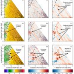
Still lots of QC'ing and processing to do, but the early lidar data shows the tornado was initially moving north-northeast before stalling and intensifying (in some unfortunate beam blockage) and then moving due east.

🌪️05/17: The LIFT project used LiDAR & mobile mesonets to sample ground-level wind flow on a strong tornado in Nebraska.
This type of data of both the tornado itself AND its formation at such close range and proximity to ground is rare and valuable.
🔗: inside.nssl.noaa.gov/nsslnew…
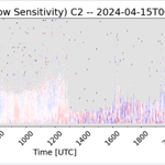
I am excited to share the EOR of our latest BAMS article! We used the @NOAANSSL truck mounted Doppler lidar to show that supercells have coherent streaks of vertical vorticity, which we refer to as vorticity worms, in their inflow. doi.org/10.1175/BAMS-D-24-03…
Conceptual models of tornadogenesis have often overlooked the inflow as a source of vertical vorticity, but the inflow is actually not devoid of vertical vorticity. Coherent turbulence found in sheared environments generates vertical vorticity right near the ground in the inflow.
If the warm nose is as strong as what is shown by the ECMWF then I think that it's 2-m temperature over the southern Plains is garbage. I would be willing to bet that the freezing line is closer to Houston than Dallas at 12 Z on Saturday. It's AI companion has the right idea.


Josh Gebauer retweeted

NSSL 2025 "WRAPPED" Take a look at the tornadoes that defined our year! 🌪️
⛈️ Precise measurements of free-falling hail and tornado winds lead to better prediction methods, can lead to improved building design standards and ultimately help keep people safe. @NOAAResearch @NOAA


Josh Gebauer retweeted
🌪️Rare start to finish EF‑3 Tornado Data Captured 🌪️
On 5/18/25 a tornado touched down near Arnett, Oklahoma. Our researchers were in place to intercept the storm and capture stunning data of the EF3-rated tornado from beginning to end. 🌪️🔬
FULL STORY: inside.nssl.noaa.gov/.../nss…
Josh Gebauer retweeted
🌪️🌩️ Studying tornadoes in the field has always been at the heart of the NSSL mission. With roots in the 90s, the VORTEX-USA project continues to blaze a trail in tornado science with the ultimate goal to protect lives and property.
🌪️ UP CLOSE: inside.nssl.noaa.gov/nsslnew…
Classic conditions for a central Oklahoma high temperature bust. Shallow cold air with high pressure to the northwest. The negatively buoyant air over the sloped terrain enhances the northerly winds in the cold air which causes the it to surge farther south.
Josh Gebauer retweeted

Our US Patent application for the CopterSonde has been granted! The new patent is a step forward in harnessing leading-edge technology for weather sampling. This positions OU/CIWRO as pioneers on creating UAS designs tailored to atmospheric studies and weather applications. 1/2

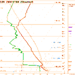
This is a great example of why underdone dewpoints by the HRRR are not always a sign the environment is more favorable than forecast. This HRRR profile has 2616 J/kg of MLCAPE and -99 J/kg MLCIN, the observed profile has 1446 J/kg and -194 J/kg even with a 5 F dewpoint error.


Overmixing effects both temperature and moisture. This often means that temperature profile is more favorable than forecast and the dewpoint profile is less. The two errors can offset each other so the forecast convective forecast might not be terrible.