

Weather, alerts & local news for NE Tennessee & SW Virginia since 2013.
Tri-Cities NE TN / SW VA
Joined March 2012
- Tweets22K
- Following93
- Followers2K
- Likes2.2K




10:49 AM ET 11/8/26: A Frost Advisory has been issued for Greenup, Carter, and Boyd & Others in parts of NE KY, SE OH, SW VA, and WV until 10 AM EST Monday. Temps near 33F may form frost; cover sensitive plants to prevent damage.

7:00 PM ET 11/6/26: Atlantic Tropical Weather Outlook in effect for Atlantic until 3:23 AM EST Sunday. #1 48h 0% / 7d 0%.

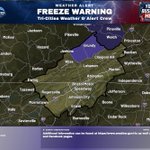
4:37 PM ET 11/7/26: Freeze Warning is in effect for Greenup, Carter, and Boyd in KY, plus southeast OH, southwest VA, and central/southern/western WV through 10 AM EST Sun. Temps down to 31F; frost/freezes may kill crops and damage unprotected outdoor plumbing.

1:00 PM ET 11/7/26: A non-tropical low south-southeast of Bermuda has disorganized showers and thunderstorms with a sharpening frontal structure. It has a 10% chance to develop in 48 hours and 10% in 7 days.

7:00 AM ET 11/7/26: A non-tropical low south-southeast of Bermuda has disorganized showers and thunderstorms, with a 10% chance of subtropical development through 48 hours and 7 days.

1:00 AM ET 11/7/26: A non-tropical low south-southeast of Bermuda has disorganized showers and thunderstorms and could gain some subtropical traits tonight. 10% chance of development through 48h and 7 days.

11:30 PM ET 11/6/26: Freeze Warning has been issued for Buchanan and Dickenson Counties, VA & Others, and Logan, McDowell, Mingo, and Wyoming Counties, WV from midnight Sat night to 10 AM EST Sun. Temps down to 30F may kill crops and damage unprotected outdoor plumbing.

7:00 PM ET 11/5/26: A non-tropical low south of Bermuda has a 10% chance of development through 48 hours and 7 days, with disorganized showers and thunderstorms. Gale-force winds are likely over parts of the central subtropical Atlantic through the weekend.

1:00 PM ET 11/6/26: A non-tropical low south of Bermuda has limited showers, with a 10% chance of subtropical development through 48 hours and 10% through 7 days. Gale-force winds are likely over parts of the central subtropical Atlantic through the weekend.

7:00 AM ET 11/6/26: A gale-force non-tropical low several hundred miles south of Bermuda has 20% chance to form into a tropical cyclone in 48 hours and 20% in 7 days. Gale-force winds likely over parts of the central subtropical Atlantic through the weekend.

5:26 AM ET 11/6/26: Dense Fog Advisory has been issued for Cherokee, Clay, Scott & Others in parts of southwest NC, east TN, and southwest VA until 9 AM EST/8 AM CST. Visibility under 1/4 mi mainly in valleys and near waterways; use caution while driving.

3:27 AM ET 11/6/26: Special Weather Statement issued for Dickenson, Buchanan, Mingo, Logan, Boone, Clay, Braxton, McDowell, Wyoming, Upshur, & Others this morning. Dense valley fog may cut vis to under 1/4 mi at times; slow down, use low beams, and leave extra space.

2:36 AM ET 11/6/26: Special Weather Statement is in effect for Cherokee, Clay, Scott, Campbell, Claiborne & Others until this morning, with fog causing visibility under 1/4 mile at times in river valleys and near lakes. Slow down, use low beams, and keep extra distance.

1:00 AM ET 11/6/26: A gale-force non-tropical low a few hundred miles south of Bermuda brings cloudiness and showers and could gain some subtropical traits. Formation chance is 20% in 48 hours and 30% in 7 days.

7:00 PM ET 11/4/26: A gale-force non-tropical low a few hundred miles south of Bermuda has disorganized convection; 30% chance to develop in 48 hours and 40% in 7 days. Gale-force winds likely over parts of the central subtropical Atlantic through the weekend.

1:00 PM ET 11/5/26: A gale-force non-tropical low a few hundred miles south of Bermuda has disorganized convection; 30% chance of development in 48 hours and 40% in 7 days. Gale-force winds possible over parts of the central subtropical Atlantic through the weekend.

7:00 AM ET 11/5/26: A broad non-tropical low a few hundred miles south of Bermuda has disorganized convection mainly east of its center. 30% chance of subtropical/tropical development in 48 hours and 50% in 7 days as it drifts slowly east; conditions turn unfavorable by...

1:00 AM ET 11/5/26: A non-tropical low a few hundred miles south of Bermuda has a 30% chance to develop over 48 hours and a 50% chance over 7 days, with subtropical characteristics possible this weekend. Conditions turn unfavorable by early next week.

7:00 PM ET 11/3/26: A non-tropical low a few hundred miles south of Bermuda has a 30% chance to develop in 48 hours and 50% in 7 days, gradually gaining subtropical traits this weekend. Slow eastward movement may bring rough seas in the western/central subtropical Atlantic.

