

PhD in atmospheric science. Postdoc at UIUC. Current research: Extreme rainfall in a warmer climate, simulated supercells, and streamwise vorticity currents.
Joined July 2016
- Tweets493
- Following140
- Followers382
- Likes2K

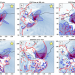



As a last promotion for the new paper (doi.org/10.1175/MWR-D-25-019…), here's a peak at one of our figures. Plotted is mean streamwise vorticity below 2 km (shaded and blue contour), reflectivity (black), and surface convergence (red).


The last of my PhD work with @VORTEXJeff titled "Characteristics of Streamwise Vorticity Currents in Simulated Supercell Thunderstorms Using Free-slip and Semi-slip Lower Boundary Conditions" has been accepted for publication in @ametsoc MWR!
We found that surface drag has little impact on SVCs along FFCBs since they develop farther above the surface. SVCs along LFCBs develop closer to the surface and exhibit decreases in streamwise vorticity and increases in crosswise vorticity as trajectories approach the surface.
2
3
137
Our article is now available in Monthly Weather Review here: doi.org/10.1175/MWR-D-25-019…
If most supercells are capable of producing sufficient sub-tornadic vorticity near the surface to be stretched (Coffer and Parker 2018), then persistent convergence beneath the low-level mesocyclone is the name of the game for increasing the probability of tornadogenesis.

In 109 supercells, tornadic storms tended to have stronger, more organized rear-flank winds directed toward the low-level mesocyclone. Buoyancy differences were small, suggesting that outflow organization mattered more than whether it was warmer or colder. #AMSMadisonSummit

2
24
1,830
SVCs along FFCBs may exhibit less streamwise vort than SVCs along LFCBs, but they may be less susceptible to the effects of surface drag. We also note other interesting storm behaviors between our free-slip and semi-slip simulations. Early online release link will be shared soon!
4
78
Kevin Gray retweeted

📢Researchers using CM1...I created a web-app to interactively generate input_sounding files. You can upload your own SHARPpy format, resample to desired dz, GUI edit, table edit, and save for use in CM1. Happy storm creation! atlas.niu.edu/cm1gen/
Just ran HRRRcast for the first time. Tested a 6 hour forecast, each hour time step took ~70 s. Our research team @CliMAS_Illinois will likely use a HRRRcast ensemble to produce probabilistic forecasts of heavy rain. These forecasts can then help with flood prediction.


8
642
I believe this is where the radar that detected the first hook echo was once located. It’s at Willard airport and you can see it from hole 14 of university of Illinois golf course (the blue course) if you’re ever in Champaign!



Play suspended at the Philadelphia Eagles stadium, rightfully so, for lightning in the area. But they broadcasted a severe thunderstorm warning message on the stadium PA, which appears to be inaccurate?
3
396
We're working on using @nvidia 's CorrDiff model to help with uncertainty in rainfall forecasts. The model is trained to take in GEFS data and generate a HRRR-like output. GEFS has 31 members and CorrDiff can generate several samples, giving many possible rainfall solutions.


1
7
321
The beauty here is we’re just using forecasts that already exist and downscaling them in a few minutes using CorrDiff. The images above are forecasts for tomorrow at 18z. I generated 4 samples, two look realistic and the other two forecast no significant precipitation over IL.
1
1
128

Kevin Gray retweeted

For years, I've wanted a way to get a text when friends or family across the country were under critical NWS warnings—so I built it. Meet nausicawx.com.
Tornadoes, severe storms, flash floods, freeze warnings, and more. Get instant SMS alerts for multiple locations.
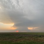
Targeted Lawton, OK, for the last day of our trip. We’ll see if one of these can take off out ahead of the cold front farther west.

3
116


