

Storm Relative Radar Loops etc
Joined April 2021
- Tweets5.4K
- Following999
- Followers7.8K
- Likes9.8K




Pinned Tweet
Overview of the Dec 10th 2021 EF4 tornado including an extensive damage is finally done! Here: vortmaxblog.wordpress.com/20…
SRRadarLoops retweeted

URGENTE 🌪️ Registros del inicio del tornado el cual cruzó la Ruta 5 Sur, con dirección hacia sectores urbanos y agrícolas de #Requínoa, región de O'Higgins.
©️ Video compartido por la comunidad de RedGeoChile.
#SRRadarLoop of the March 31 2023 Little Rock tornado. This tornado was rated very high end EF3 with winds of 165 mph. Topography was an influence on tornadogenesis and enhanced areas of damage.
SRRadarLoops retweeted

This isn't lightning, but it's still electric! ⚡ A pilot flying in Australia captured a phenomenon known as St. Elmo's Fire.
It occurs when strong electric fields ionize the air, creating glowing plasma along parts of the aircraft, including the windshield. The phenomenon itself isn't dangerous, but it can be a warning sign of nearby thunderstorms and lightning.
SRRadarLoops retweeted

This flash flood was the seed that closed I-40 today west of Laguna, New Mexico
Do not attempt - I am a trained professional
SRRadarLoops retweeted

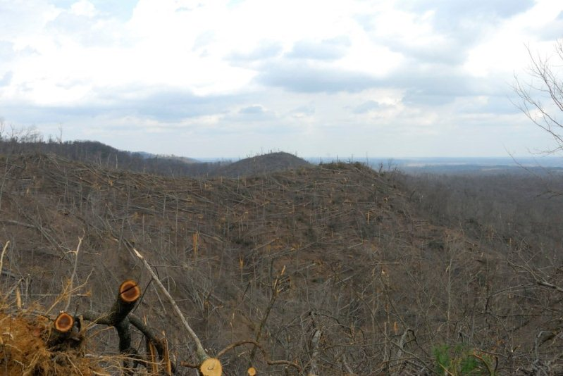
Out droning today.. this is where the EF4 Tornado ripped and went across a whole ass mountain in Pulaski county 🏔️ zoom in.. @Kentuckyweather

SRRadarLoops retweeted

While 2008 had it's share of strong tornadoes, many overlook the Damascus, Arkansas EF3 of May 2, 2008.
Not only did this violent tornado occur at 8am, but the damage was quite high-end north of town. Houses were swept, vehicles thrown, and trees severely denuded.
🧵 #wxtwitter


(1/4) #SRRadarLoop of the March 2nd 2012 Henryville IN tornado. The NWS rated this tornado EF4 with 175 mph winds and a path length of 49 miles.
(3/4) Severe debris granulation occurred in Marysville. Near Chelsea a well bolted home was swept away with multiple vehicles thrown. A large backhoe in the area was thrown 200 yards.


(4/4) The Henryville tornado could have easily been higher-end EF4 to even EF5 strength (especially based on tree damage at the Clark Forrest) but construction in this area isnt well enough for that rating. Shout out to people like @mammatusman for warning people that day!

SRRadarLoops retweeted

All 3 videos with movement of actual vortex, the tornado was overcondensed (thanks to high relative humidity), with the small vortex sitting on the backside of the tor. The video ends right as winds accelerate to ~110-125 MPH, with passage of 150-160 MPH winds just moments after.


Extreme damage from the Windsor Locks CT F4. Using Today’s EF-Scale this is easily upper end EF3 >160 mph.


SRRadarLoops retweeted

September 18, 2026: Francis Peak, UT EF2 Tornado
@NWSSaltLakeCity tornado survey has been completed for the tornado that occurred just east of Fruit Heights, UT on Francis Peak from 1:44PM to 2:00PM MDT on September 18, 2026.
🌪️ Maximum Winds: 120 MPH
🌪️ Length: 5.93 MILES
🌪️ Width: 1.1 MILES
Visualization has tornado swath path and starts with 2D Radar and then faces west to show 3D radar as tornado goes up and then down Francis Peak.
@weatherchannel #utwx #francispeaktornado #tornado
SRRadarLoops retweeted

New unreleased footage of the Union City, Michigan EF3 tornado back on March 6, 2026, capturing the moments before the tornado hits.
📸: Unknown, taken from Discovery Channel doc
(if anyone can help me find the og person of this footage, I will be greatly appreciated)


