

Become a citizen scientist, and monitor rising seas, intensifying storms, and other weather events with the Coastal Observer App!
Newark, DE
Joined April 2020
- Tweets91
- Following75
- Followers26
- Likes32


Pinned Tweet
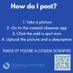
Visit coastalobserver.net to post an observation about the weather or water level in your area! The observation are very useful when looking back at trends and weather patterns in the past.

The NWA Regional Climatology (RC) version 2 replaces the previous version of the NWA RC published in 2016. The new version allows researchers to assess decadal ocean climate change more precisely in the critically important NWA region.
ncei.noaa.gov/products/north…
8-14 day prediction for precipitation across the United States


Coastal Observer retweeted

Arctic air will infiltrate the Plains & Intermountain West. Moisture combined with this cold air will bring heavy NW mountain snow & a wintry mix to the Plains. Heavy snow & Lake Effect snow in the Northeast. A Gulf Coast system may produce locally heavy to excessive rain.

Aviation code RED means that it is likely an eruption is imminent with significant emission of ash into the atmosphere


Interested in sea level change around the world? The NOAA website has an interactive for anyone to use for research or for fun.
climate.gov/teaching/resourc…
Coastal Observer retweeted

Around 11:30 p.m. HST last night, @NOAA's #GOESWest 🛰️ captured the eruption of Hawaii's #MaunaLoa volcano, inside @Volcanoes_NPS.
This imagery shows the heat signature and the sulfur dioxide released from the #volcano's summit caldera, Moku‘āweoweo.
Coastal Observer retweeted

At approximately 11:30 p.m. HST this evening, November 27, an eruption began in Moku‘āweoweo, the summit caldera of Mauna Loa, inside Hawai‘i Volcanoes National Park. Winds may carry volcanic gas and possibly fine ash and Pele’s hair downwind.
Photo Credit: USGS


Coastal Observer retweeted

We flew over communities affected by Hurricane #Nicole to assess the damage. The images were collected in specific areas identified by NOAA in coordination with @FEMA and other state and federal partners. Visit our site to see all the photos: storms.ngs.noaa.gov/storms/n…

ALT graphic of the area covered titled "Hurricane Nicole Damage Imagery"
Coastal Observer retweeted

As @COP27P draws to a close, remember that all year long NOAA provides reliable, easy-to-use #climate & extreme weather information to help make informed decisions.
Visit climate.gov/COP27 for access to recorded COP27 sessions & more.
#COP27NOAA

ALT COP27 logo/graphic with text: "COP27 Sharm El-Sheikh Egypt 2022 6-18 November."

Coastal Observer retweeted

⚠️ GLOBAL CLIMATE REPORT: See the October 2022 Global Significant Climate Events Map and learn more about worldwide climate conditions: bit.ly/Global202210 #StateOfClimate

ALT World map showing significant climate anomalies and events in October 2022 with text describing each event
"It’s very likely that La Niña will last through the winter (December–February), with a transition to ENSO-neutral (neither La Niña nor El Niño) expected during February–April."
More Info:
climate.gov/news-features/bl…


As you may have guessed, La Niña is still in charge in the tropical Pacific.
For the forecast: There’s a 76% chance La Niña will be present this winter, with a transition to neutral favored for spring. climate.gov/news-features/bl…
Coastal Observer retweeted

11:55 AM EST Wednesday Update: Tropical Storm #Nicole makes landfall on Great Abaco Island in the northwestern Bahamas with maximum winds of 70 mph (110 km/h). Latest at hurricanes.gov


Coastal Observer retweeted
Folks all along the East Coast need to monitor #Nicole as it may bring flooding impacts all the way from Florida to Maine.


Lots of rain around Delaware, Pennsylvania, and New Jersey today, it’s a great time to record some water level observations on the coast, or some weather observations. Stay dry observers! instagram.com/p/CcDuFCbJNdO/…

Coastal Observer retweeted

3:18pm CDT #SPC_Watch WW 89 SEVERE TSTM DE MD NJ NY PA CW 312015Z - 010400Z, go.usa.gov/xztsg


