







Steve Piltz retweeted

The Tigers survive a Thursday night thriller at Edmond North to complete a perfect 10-0 regular season!
Final Stats: live.gamedaypreps.com/16669
Next up... The Tigers earn a first-round bye in the OSSAA Class 6A-I Playoffs and will host a quarterfinal matchup on November 20 at Tiger Field!
#BuildTheLegacy x #goba 🐅

Steve Piltz retweeted

ECMWF seasonal snowfall totals. Seems too high of course for a lot of areas, but fun to look at.


Steve Piltz retweeted

NOAA retired the NAM this week. We ported it to the GPU and it's back, better than ever: WOOF-NAM, open source.
- 12 km CONUS, all NAM physics, 24 h forecast in ~20 min on a single RTX 5090 (32 GB).
- 8 GPUs: 6 h in 92 s. Multi-card is bitwise to single card.
- 4 km CONUS, 24 h in under 9 min on 8 GPUs. 3 km nests anywhere on Earth (Europe, Japan, CONUS): 48 h in ~7 min on one card.
SStarts from the NAM analysis or GFS today, IFS open data in the next release. Beside the operational NAM from the same cycle it's hard to tell them apart (pics).
Today it needs one 32 GB card for the full 12 km CONUS; ~15 GB is the target, coming soon.
github.com/recastsystems/woo…


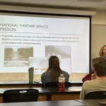
. @kahatfield from @NWStulsa speaking this evening at @brucewxman ‘s class at the University of Arkansas. #arwx


Steve Piltz retweeted

Earth is getting hammered! Thanks to a fashionably late solar storm impact and continued flaring from Region 4549, impacts at Earth are building up. Aurora photographers should be seeing aurora where skies are clear while radio operators & GPS users should stay alert for increased signal degradation and noise on both the day and night sides of Earth. Conditions will worsen over the next 24 hours.
Steve Piltz retweeted

Honoring a sports legend from the eye of #HurricaneIsaias. ✈️💨
Our crew just launched dropsondes into the storm in honor of Coach Ditka on the landfall mission. It begs the ultimate question
"Who would win, Ditka or a Hurricane?"
@ESPN @ChicagoBears #Isaias #ChicagoBears #NFL


Steve Piltz retweeted

There are a whole lot of people from around the state and country working to keep you safe right now! But ultimately, the best person to keep you safe is YOU. Follow reputable sources of weather info and heed the advice of your local emergency management offices!


Steve Piltz retweeted

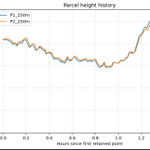
For anyone curious what we do, here is the situational awareness software. dots are UAS going in the eyewall at 250 m altitude. In this case, I'm trying to get high winds to help the NHC forecaster while also avoiding the nastiest stuff on radar that can sink the drone. #Isaías


Steve Piltz retweeted

JUST IN: Saildrone Explorer SD-1045 passed through the eye of Category 3 Hurricane Isaias, recording wind gusts over 90 knots (103 mph).
This is the same USV that filmed inside Hurricane Sam in 2021, setting a Guinness World Record.
Watch ↓ @NOAA_AOML @noaapmel
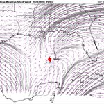
RAP data... cyclone-relative (kt) ... this evening at 150 mb... a part of the upper-level outflow for Isaias ...

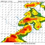
.@recast WOOF WRF+ERA5 output from December 18, 1957... Murphysboro, IL F-4 tornado... 32 years after the Tri-State Tornado...

Steve Piltz retweeted
Yes, even the National Weather Service takes shelter when we are under a tornado warning. This was our office during one of two shelter in place events during the tornado event last night. We are so thankful @NWStulsa performed our duties for us so we could remain safe.

ALT NWS employees taking shelter during a tornado warning even with protective helmets from flying debris


18Z AI GFS placing more emphasis on western QPF axis in E OK... somewhat similar to ECMWF / AI ECMWF


Steve Piltz retweeted

Back to academia for a day! 🎓
I headed to the University of Arkansas for meetings with students and professors, then gave a guest lecture on using tiltmeters—from Antarctic glaciers to Oklahoma earthquakes.
One of the things I miss most about academia.
#Geophysics