

20 | ✝️ | Central Alabama Weather | National Wx: @weathertrackus
Alabama
Joined September 2016
- Tweets22.8K
- Following115
- Followers3.9K
- Likes14K




Star retweeted

Cooler weather is expected for Central & Southern portions of the U.S. this weekend and early next week, before mild temperatures return.
There is some signal that a large trough in the East could bring in significantly cooler air for the Eastern U.S. mid to late next week, although confidence in that is fairly low at this time.
Mild temperatures will settle in for much of North America through mid-November, as the -PNA stays negative, and an active troughing pattern returns from the West, perhaps introducing more severe weather potential through the given period.
Star retweeted
A few isolated strong-severe storms, capable of strong wind gusts, and a tornado or two will be possible across parts of the Deep South this afternoon, as a line of storms races eastward along a strong cold front.

Star retweeted
The SPC has introduced a Level 3/5 - Enhanced Risk across portions of Oklahoma and Kansas today.
This risk is driven by tornadoes, where several tornadoes are possible, including a risk for a strong tornado or two.
The main timeframe will likely be from 4-9pm CST.

Star retweeted
Severe weather is likely on Day 3/Monday across parts of the Great Plains, mainly from far North Texas to Northern Kansas.
A large trough, paired with a subtropical jet, will pull rich surface moisture northward across the Plains, with adequate instability, sufficient to support a few severe storms.
A mixed mode, featuring supercells and line segments appears likely, capable of producing all severe hazards, including a few tornadoes.


Star retweeted
NEW:
The Storm Prediction Center, on or about November 16, 2026 will begin issuing afternoon Day 4-8 Severe Weather Outlooks, at 2130 UTC (4:30 PM CDT/3:30 PM CST).
The content and format of the outlooks will not change; only the addition of afternoon issuances.

Star retweeted
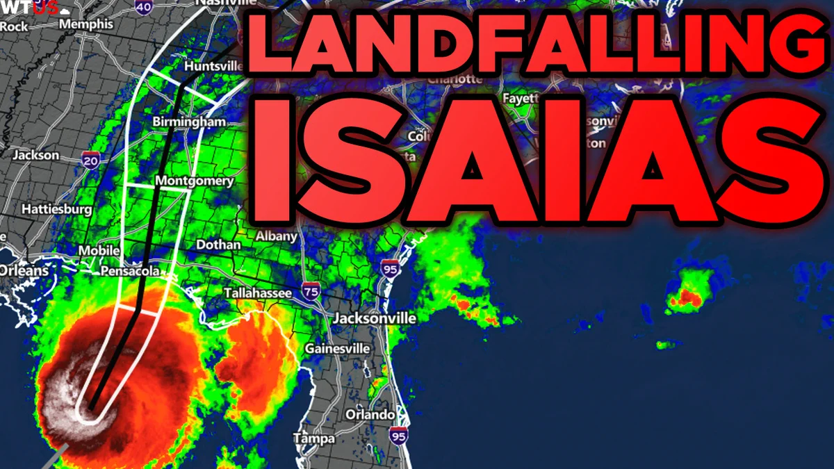
We're live tracking Isaias as it barrels down on the Gulf Coast. Stay tuned for live coverage starting this evening! teapaw.org/i/broadcasts/1nxnRBlBB…
Star retweeted
NEW Details on Soon-to-Be Hurricane Isaias:
youtube.com/watch?v=w0ZSZbpF…

Star retweeted
Tropical Depression Nine has formed in the Gulf, soon to be Isaias.
Here's the latest:
youtube.com/watch?v=rouurIuP…

Star retweeted
All severe hazards appear possible across parts of the Plains tomorrow (Wed, Sep 30).
As an upper trough and the remnants of Polo move out of the Rockies, a deep plume of moisture and strong low-level shear will overlap from Texas to Nebraska.
At the triple point in Kansas and Southern Nebraska, a few transient supercells may develop by mid-afternoon, assuming adequate destabilization occurs.
Strong low-level shear should support at least modest low-level rotation, which could produce a few weak tornadoes. Isolated large hail, and damaging winds will be possible as well.
Further south, a line of storms, mainly producing flash flooding, could produce sporadic strong-severe wind gusts, and perhaps a tornado or two.


Star retweeted
Significant flash flooding, and some severe weather will impact parts of the Four Corners and Southern Plains this week!
Details here:
youtube.com/watch?v=3mnRYMQb…

Star retweeted
A Nor'easter may impact the Mid-Atlantic and New England late this week, and into this weekend.
Guidance is in very good agreement that a strong low will develop off the East Coast, bringing heavy rain and strong winds to coastal, and even interior regions.
There remains a fair bit of uncertainty regarding the intensity and the track of the system, with still some potential of minimal to no impacts, but there is at least medium confidence in a moderate-high impact event, at least for coastal regions. Updates will be provided throughout this week.
Star retweeted
Some tornado threat (alongside a wind/hail threat) may develop across parts of the Dakotas this evening as a line of supercells develops in North Dakota in a moderately unstable and sheared environment. Although large hail will likely be the primary hazard, a couple of tornadoes will be possible as well.
Across parts of South Dakota, the threat is more conditional, as storm development is uncertain. If storms develop between 5-8pm CDT, the threat for large hail, and a couple of tornadoes may materialize. A strong tornado won't entirely be ruled out, given elevated shear profiles, but the overall tornado threat should generally remain on the lower-end.


Star retweeted
Any Heat Relief on the way for the South and Great Plains this month?
Well...
youtube.com/watch?v=VwBdLpFO…

Star retweeted
There is a risk of all severe hazards across parts of Western New York and Central Pennsylvania late this afternoon, and into this evening.
A mix of supercells and line segments are forecast to move into an unstable and highly sheared environment.
If the storm mode remains more cellular, tornadoes and hail will be the dominant hazards, with a strong tornado or two not being ruled out. However, if the storm mode remains more linear, damaging winds will be the primary hazard, although embedded tornadoes will be possible as well.


Star retweeted
Severe thunderstorms are possible across parts of the Great Lakes and Northwest region on Wed, September 2nd.
A strong upper trough will move atop a band of strong instability across the region, perhaps producing multiple rounds of strong-severe storms, or a long-lived complex.
Uncertainty remains regarding the area, timing, and severity of the severe potential, but updates will be made when details become more clear.


Star retweeted
At least a couple of tornadoes will be possible across parts of Illinois, Indiana, Michigan and Ohio tomorrow afternoon/evening.
A cold front will slowly move through the region, supporting a risk for a few isolated supercells in a moderately unstable and sheared environment. Damaging winds, large hail, and some tornado threat will develop from the stronger storms.

Star retweeted
More Severe Storms & Tornadoes are Forecast Across the Midwest & East Coast today and tomorrow!
youtube.com/watch?v=IDssTSrP…
Star retweeted
Our 'Early' Fall 2026 Prediction is out!
youtube.com/watch?v=FRXxvIOj…

Star retweeted
More Severe Weather and Flash Flooding is expected today and tomorrow, impacting parts of the Plains, Midwest & East Coast.
VIDEO:
youtube.com/watch?v=GRZQu3qA…

Star retweeted
NEW Video! - Southern Heatwave, MORE Severe Weather & Tropics!
youtube.com/watch?v=vaqJ0_wA…
