Team Dominator Storm Recovery provides community support after weather-related disasters.

Joined July 2024
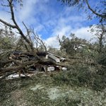
We wanted to take a moment to shine some light on this angel on earth, Merrie Schwartz. She fosters disabled children in her home and currently has 8, though she has had over 30 in the past. During Hurricane Isaias, trees were blown down onto her roof, causing water to pour into one of the children’s rooms where they have vital medical equipment. Merrie reached out to her church, and our team happened to be on location at Mercy Chefs picking up a food delivery for Santa Rosa County Sheriff's Office FL. One of her church members asked if we could assist her with tree removal. Being on deployment with United Cajun Navy, we immediately put in a request and began the process of getting her as much assistance as possible with tree removal, hot meals and supplies. This amazing lady, even though her home was damaged and she has devoted her life to helping others, was determined to get to the church to continue volunteering for others in her community affected by the Hurricane. The world is a better place with her and her beautiful family in it. We are grateful for God's Pit Crew for all their hard work in assisting this family. When teams work together, big things happen. #hurricane #isaias #DisasterRecovery #disaster #unitedisstrength #unitedcajunnavy tdstormrecovery.org
1
5
228
Team Dominator Storm Recovery retweeted
🌊INTENSE COLORADO FLOODS: Floodwaters are finally beginning to recede along the San Juan River but flooding and road closures remain across parts of Pagosa Springs, Colorado. Intense thunderstorms triggered evacuations and a local disaster emergency was declaration late Thursday. Watch FOX Weather for the latest storm forecast:
6
34
6
89
4,906
Team Dominator Storm Recovery retweeted
As our storm system finally starts to push east, the precip will also start to slide east. Showers and storms will increase in coverage today, with moderate to heavy rain possible across the plains. Remember, if you come across flooded roads, Turn Around Don't Drown. #cowx
2
17
1,095
Team Dominator Storm Recovery retweeted
Replying to @OZsaferoomsTech
@OZsaferoomsTech putting in our first storm Saferoom! With @erikfox2000 , @hollyisloud and @EdgarONealWX
1
9
26
2,088
Team Dominator Storm Recovery retweeted
October 23, 1920: Dr. Ted Fujita was born in the Fukuoka Prefecture of Japan. Fujita devoted his life to the study of tornadoes, supercells, and downbursts. He is most notably the creator of the scale utilized by the National Weather Service to rate tornadoes. #wxhistory
1
80
14
352
12,761
Team Dominator Storm Recovery retweeted
10/23/2026 Don't delay - visit a DRC today! The disaster recovery centers in Perry and Franklin Counties are open to disaster survivors from the seven declared counties. There is no scheduled closing date at this time. See hours of operation: bit.ly/4jP8nhj
2
1
1,633
Team Dominator Storm Recovery retweeted
We are so pumped about Monday!
3
10
614
Please donate if you are able to this incredible lady and her family who fosters disabled children in her home and volunteers for her community. Her home was damaged during Hurricane Isaias and she is in need of a new roof to stop leaking onto the children’s medical equipment. #hurricane #isaias #flooding #tornado gofund.me/e0c0955ed
3
1
9
216
Team Dominator Storm Recovery retweeted
A tornado watch has been issued for parts of Arizona until 6 PM MST
1
126
26
342
33,364
Team Dominator Storm Recovery retweeted
The Storm Prediction Center (SPC) has placed portions of the area in a Slight to Enhanced risk for severe weather Wednesday. The primary threats will be large hail and damaging winds, but an isolated tornado or two can't be ruled out. Be sure to stay weather aware! #azwx
10
52
11
370
49,543
Team Dominator Storm Recovery retweeted
Tornado Warning continues for Deming NM until 6:15 PM MDT
1
16
1
52
13,982
Team Dominator Storm Recovery retweeted
Tornado Warning continues for Emison IN until 7:45 PM EDT
1
10
1
30
12,261
Team Dominator Storm Recovery retweeted
Tornado Warning including Emison IN until 7:45 PM EDT
8
1
31
10,100
Thankful to assist @Unitedcajunnavy in disaster recovery efforts after Hurricane Isaias. There is a beautiful part to storms in seeing hope in the faces of those we assist and forming friends and partnerships along the way. We all work together for the same mission. #hurricane #Isaias #flooding #DisasterRelief
2
10
401
Debris clearing in Milton , Florida
4
1
27
679
Team Dominator Storm Recovery retweeted
Tornado Warning continues for Barnwell County, SC until 5:00 PM EDT
13
1
15
8,631
Team Dominator Storm Recovery retweeted
7:20 AM CDT Friday Oct 9 Update: Isaias becomes a major hurricane. Data from an Air Force Reserve hurricane hunter aircraft indicate that the maximum sustained winds have increased to 120 mph. Isaias is now a category 3 hurricane on the Saffir-Simpson Hurricane Wind Scale. Follow the latest at hurricanes.gov
23
483
68
1,072
195,167
Team Dominator Storm Recovery retweeted
ISAIAS ON FINAL APPROACH: Alrighty gang... this is the final call on what to expect hazards-wise. The hazards overlap. Find yourself on the map, and then see which box(es) you're in. PINK: The eyewall will affect you. Winds. gusting 80 to 100 mph, commensurate with Category 2 impacts. Power outages likely. Tree damage possible to hardwoods; palms should be mostly alright. Loose outdoor objects are tossed around. Scattered to numerous power outages. (In Pensacola, there could be a secondary burst of winds on the back side of the system out of the west-northwest... perhaps stronger than the initial side of the eye. As dry air sneaks into the circulation and erodes part of the eyewall, a "stinger" could form. While not technically a sting jet, somewhat similar processes could help make a nasty backlash of wind.) RED: Winds gusting 56 to 80 mph. Some of that is on the east side of the eyewall but outside the eyewall itself. The rest, especially in Alabama as far north as Montgomery and south of Birmingham, is from the remnant eyewall. Scattered power outages likely, and tree damage is probabkle. GREEN: This is where rainfall could overachieve, but uncertainty abounds. Confidence is high in widespread 6 to 10 inch totals, but a narrow strip of a LOT more is possible IF the feeder band swirls over the same areas for long enough. In that case, downpours would train, or move repeatedly over the same areas. BLUE: Surge. A hazardous storm surge is likely on the right side of the system, with a broad 3 to 7 feet of inundation. If you live on the immediate coastline within 7 feet of sea level, move up or inland. YELLOW: Scattered tornadoes are likely either Friday afternoon/evening or Saturday. Downpours in Isaias's feeder bands will tap into shear, or changing winds with height, associated with the overall circulation. That means some of the cells will rotate and could produce tornadoes. An isolated significant (EF2+) tornado can't be ruled out.
21
114
10
686
200,360
Made it to Pensacola. Ready to assist anyone in the damage path tomorrow. Beautiful calm before the storm.
2
46
808
Team Dominator Storm Recovery retweeted
🚨 EVACUATION ORDERS issued for ALL of 30A and surrounding areas ahead of Hurricane Isaias. IF YOU ARE VISITING THE AREA ON FALL BREAK, IT IS TIME TO LEAVE THE AREA. 🔴 WALTON COUNTY: MANDATORY evacuation for Zones A, B and C, in effect since noon Thursday. This covers all of 30A (Dune Allen, Blue Mountain, Grayton, WaterColor, Seaside, Seagrove, Watersound, Alys, Rosemary and Inlet Beach), plus Santa Rosa Beach, Miramar Beach, Point Washington and low-lying areas around Freeport and Choctawhatchee Bay. Officials cite about 7 feet of possible storm surge. 🟠 BAY COUNTY: VOLUNTARY evacuation for Zones A and B, effective immediately. This includes Panama City Beach, Laguna Beach, Mexico Beach and low-lying areas around St. Andrew Bay, plus anyone in a mobile or manufactured home anywhere in the county. Dangerous storm surge up to 7ft above ground level expected with dangerous 80mph+ wind gusts possible. Hurricane conditions are expected Friday night into early Saturday. Shelters are open in both counties. Look up your zone at floridadisaster.org/knowyour….
14
197
11
772
111,446